


Vendor Needed: Exterior Elevations Created From Matterport Pro2 360 Views16206
Pages:
1
 WGAN Forum WGAN ForumFounder and Advisor Atlanta, Georgia |
DanSmigrod private msg quote post Address this user | |
| Vendor Needed: Exterior Elevations Created From Matterport Pro2 360 Views Hi All, A WGAN Member seeks a vendor to provide exterior elevations from Matterport Pro2 360 Views (plus key measurements via a handheld laser distance measurer. If this workflow is possible, the WGAN Member likely has ongoing work for this vendor with two sizes of spaces: 1. under 5,000 SQ FT 2. over 5,000 SQ FT (Shooting with a Leica BLK360 is not an option.) (Shooting with a drone is not an option.) Feel free to post here and/or email: DanSmigrod@WeGetAroundNetwork.com Happy holidays, Dan |
||
| Post 1 • IP flag post | ||

Fort Wayne, Indiana |
RoyceEngineering private msg quote post Address this user | |
| Hello Dan, I sent you an email for this need. Thank you Zach |
||
| Post 2 • IP flag post | ||
 WGAN Basic WGAN BasicMember Denver |
pixelray private msg quote post Address this user | |
| Anything in Denver or Cheyenne area? | ||
| Post 3 • IP flag post | ||
|
WGAN Forum Founder and Advisor Atlanta, Georgia |
DanSmigrod private msg quote post Address this user | |
Quote:Originally Posted by @RoyceEngineering I (just) replied to your email. Thanks! @pixelray Thanks for reaching out. The WGAN Member is not seeking scanning: rather exterior elevations created from existing 360 Views shot with a Matterport Pro2 3D Camera. Best, Dan |
||
| Post 4 • IP flag post | ||
|
WGAN Forum Founder and Advisor Atlanta, Georgia |
DanSmigrod private msg quote post Address this user | |
| Hi All, For clarification, a WGAN Member is seeking elevation drawings to be made from existing Matterport 360 Views (and key measurements with a hand-help laser measurer). The WGAN Member is not seeking Matterport Service Providers to do scanning. Thanks, Dan |
||
| Post 5 • IP flag post | ||
|
|
ron0987 private msg quote post Address this user | |
| @DanSmigrod it's tricky to do but depending on how many 360 views there are and if you can stitch them into one panorama few you can scale them and use them as a template and draw over them. Accuracy would be very subjective. | ||
| Post 6 • IP flag post | ||
|
WGAN Forum Founder and Advisor Atlanta, Georgia |
DanSmigrod private msg quote post Address this user | |
Quote:Originally Posted by ron0987 @ron0987 Thanks for the feedback. What direction should I give this WGAN Member regarding future Matterport Pro2 360 Views exterior shoots to help with exterior elevations? For example: 1. Is it better to shoot many 360 Views? 2. Is it better to shoot 360 Views closer to the building? 3. Is it better to shoot 360 Views every X feet and be about X feet away? Would the accuracy be "good enough" to decide where to locate stand-alone signage on the property? Dan |
||
| Post 7 • IP flag post | ||
|
|
ron0987 private msg quote post Address this user | |
| I am away from my desk driving I will be back in a few hours I will lay out a few thing they should do and post it. | ||
| Post 8 • IP flag post | ||
 WGAN Fan WGAN FanClub Member Queensland, Australia |
Wingman private msg quote post Address this user | |
| I would say loading one face that shows a building side into any vector graphic software like Corel Draw and scale it to an actual size before tracing can be the easiest way. This is of course valid if it is a single storey building photo taken at a distance and one face can show the whole side of this building and you know at least one of its features length. And to make it simple you can actually take a snapshot in Matterport workshop of each required side from a relevant 360 view to eliminate any need of using some tools to extract a cube face from each 360 view. If you do not have Corel Draw or Adobe Illustrator you can use Inkscape which is free vector software. https://inkscape.org/ The extra benefit is you can actually draw the whole plan in vector software that way with all required annotations and details for elevation plans and then output it into a PDF file. And doing 2D in vector is actually quite simple and fast so tracing should not take too much time. |
||
| Post 9 • IP flag post | ||
|
|
ron0987 private msg quote post Address this user | |
| Dan, The best way I can show you is including two examples and share my work flow. Preference: I took a job I did with several exterior shots; I will follow up with best case on site requirement to make it work. 1. In sample 2 I took the Mapport over view and took a measurement and snapshot. I imported it into a CAD program and used the measurement to scale it correctly. Because this building had depth, I used it to give me the breaks in the offset. 2. In sample 1 I imported a view as perpendicular to the building as possible from Matterport. I also took a measurement in the photo for scale. I then imported and scaled the photo in the CAD program. 3. I aligned sample 1 with the extruded lines of sample 2 and then started to draw the building. This went fairly fast and was a little more difficulty because of the offset in the building but shows it can be done. If I was going to a site to do this using a Matterport Pro 2 camera, I would take a lot of scans along the side of elevation you are looking to diagram. I would use a second digital camera to get as many photos as possible perpendicular to the building as possible. As Wingman pointed out if the elevation, you’re trying to capture is high, using a camera at ground level will give you a perspective issue in the CAD software. So, you would have to raise the camera. Overall best case scenario you are shooting one elevation of a shorter building with few offsets and not complicated building design. All that verbiage to ask, if they are using a Pro 2 camera why wouldn’t they convert it to a xyz file(point cloud) thru Matterport and use a 3D Cad program and draw the profile needed. In the first work flow if you are looking for accuracy you lose it every time you try to import and size a photo. You also loose accuracy on perspective views. To answer your three questions 1. Is it better to shoot many 360 views? 2. Is it better to shoot 360 Views closer to the building? 3. Is it better to shoot 360 Views every X feet and be about X feet away? Answers 1. Shoot as many shots as possible. 2. I would shoot at a distance from the building that gives you the best perpendicular and overlaps with another shot. 3. This one I could not give you much input on a standard, If you are doing an elevation for example that was 50’ long and 10’ high, I would set the camera at about 5’ high and shoot every 5’. But again, I would supplement if with a lot of digital shots from a regular digital camera. The supplemental shoots I would verify the heights. But get a good overlap. 4. The fourth thing I would do is take some onsite measurements, like door/window widths or heights to scale photos. I hope this helps? Sample 1 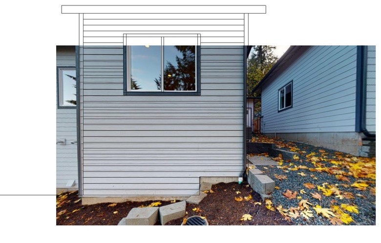 Sample 2 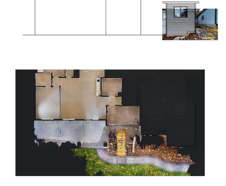 |
||
| Post 10 • IP flag post | ||
|
WGAN Forum Founder and Advisor Atlanta, Georgia |
DanSmigrod private msg quote post Address this user | |
| @Wingman @ron0987 Thank you for your detailed notes (above). Awesome! Would scanning at night with lights be a solution? For clarification, shooting 360 scans with a Matterport Pro2 3D Camera instead of shooting 360 views. This way, the depth data could be gathered without being concerned if the Matterport Pro2 Camera is in line of site of the sun (which makes a mess of the IR/mesh). Dan |
||
| Post 11 • IP flag post | ||
|
|
ron0987 private msg quote post Address this user | |
| @DanSmigrod If your using the Matterpak for the 3D data or point cloud I would not do it at night but would do it early morning or at a time sun reached a point not to be a factor or near sunset. Even though some external lighting is good for a walk thru model if you are using extracted photos for comparison for overlays shadows from lights may throw this off for using the photo for key visual comparison points. Ron |
||
| Post 12 • IP flag post | ||
|
|
ron0987 private msg quote post Address this user | |
| @DanSmigrod There is another option not using a Matterport Pro 2 camera. If you just take still 2D photos and run them thru another software to create a 3D model that you then take a screenshot and import into CAD to draw the elevation. I took 45 still shots in about 45 minutes and created this 3D model.  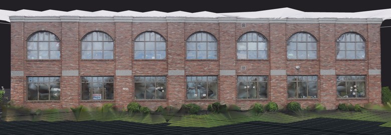 |
||
| Post 13 • IP flag post | ||
|
|
ron0987 private msg quote post Address this user | |
This way is a little cleaner but scale is still an issue. |
||
| Post 14 • IP flag post | ||
Pages:
1This topic is archived. Start new topic?