


(See Video) Question of the Day: Your Thoughts About Skydio 3D Scan?15020
Pages:
1
 WGAN Forum WGAN ForumFounder and Advisor Atlanta, Georgia |
DanSmigrod private msg quote post Address this user | |
| Video: Introducing Skydio 3D Scan™ | Video courtesy of Skydio YouTube Channel | 2 June 2021 Video: Introducing Skydio X2™ | Video courtesy of Skydio YouTube Channel | 2 June 2021 The WGAN Forum Question of the Day for Wednesday, 2 June 2021: Your Thoughts About Skydio 3D Scan? Best, Dan  Save $50 with this WGAN affiliate link for Drone Pilot Ground School and WGAN Coupon Code: WGAN50 |
||
| Post 1 • IP flag post | ||

|
MeshImages private msg quote post Address this user | |
| Excited! Skydio 3D scan would be my 1st go-to solution, if drone flight was not so heavily restricted in urban areas. I would like to see indoor 3D scan examples, if available. |
||
| Post 2 • IP flag post | ||
|
WGAN Forum Founder and Advisor Atlanta, Georgia |
DanSmigrod private msg quote post Address this user | |
Quote:Originally Posted by MeshImages @MeshImages I (just) emailed Skydio Media Relations to ask for video - and CAD examples - of indoor 3D scanning of commercial/residential real estate. Best, Dan |
||
| Post 3 • IP flag post | ||
|
WGAN Forum Founder and Advisor Atlanta, Georgia |
DanSmigrod private msg quote post Address this user | |
| Video: Skydio 3D Scan™ Keynote - The New Era of Autonomous Inspection | Video courtesy of Skydio YouTube Channel | Wednesday, 2 June 2021 From the Skydio YouTube Channel Skydio 3D Scan™ is first-of-its-kind adaptive scanning software built on top of Skydio Autonomy, the autonomous flight engine behind every Skydio drone. 3D Scan builds a real-time model of the scene, allowing the drone to automate the data capture process needed to generate 3D models with comprehensive coverage and ultra-high resolution. Read more here: Introducing Skydio 3D Scan™: The Era of Autonomous Drone Inspection is Here Interested in purchasing Skydio 3D Scan for your drone program? Contact us here: https://pages.skydio.com/Contact.html 0:00 Introduction 2:09 Skydio's Mission 2:40 Why We Need 3D Scan 4:42 How 3D Scan Solves The Problem 6:55 3D Scan Demo 12:19 Technology Deep Dive 15:45 3D Scan Results 17:25 Customer Spotlight 21:54 Conclusion About Skydio Skydio is the leading U.S. drone manufacturer and world leader in autonomous flight technology. Skydio leverages breakthrough AI technology to create the world’s most intelligent flying machines for consumers, enterprises, defense and civilian agencies. Founded in 2014, Skydio built a world class R&D team with leading experts in AI, robotics, cameras, and electric vehicles from top companies, research labs, and universities. Headquartered in Redwood City, CA, Skydio designs, assembles, and supports its products in the U.S. to offer higher standards of supply chain and manufacturing security. Skydio is trusted by leading enterprises across a wide range of industry sectors and is backed by top investors and strategic partners including Andreeson Horowitz, IVP, Playground, Next47, Levitate Capital, NTT DOCOMO, NVIDIA. Source: From the Skydio YouTube Channel --- @MeshImages This video (above) includes indoor commercial space. This is AMAZING. Granted. This is a LARGE indoor space: not a residence. Plus, they are using Skydio 3D Scan to scan a BIG OBJECT rather than the space itself. BUT, I could imagine that it works the same way for scanning smaller indoor spaces (like a house or condo for sale, lease or rent). Dan  Skydio Launch Partners: Screen Grab from Skydio video (above) |
||
| Post 4 • IP flag post | ||
|
|
MeshImages private msg quote post Address this user | |
| Amazing! Now we need a player, that integrates these 3d exterior models into our presentations. So sad, that GeoCV is not an option anymore. I hope, that 3DVista will be coming up with something like depthmaps or a handy obj/pointcloud player module. |
||
| Post 5 • IP flag post | ||
 WGAN Fan WGAN FanClub Member Buffalo, New York |
GETMYVR private msg quote post Address this user | |
| The desire to push the limits continue to morph our ever increasing opportunities as creators into an expanding universe. Neat stuff. | ||
| Post 6 • IP flag post | ||

|
remaxvictory private msg quote post Address this user | |
| Is anyone using sketchfab for hosting? Would love to add the skydio workflow to create something like this and hosting seems reasonable, but not sure what all entailed with creating this type of model: https://skfb.ly/6ZSwv | ||
| Post 7 • IP flag post | ||
|
WGAN Forum Founder and Advisor Atlanta, Georgia |
DanSmigrod private msg quote post Address this user | |
| Video: Interview with Skydio Executives about Skydio 3D Scan(TM) | Video courtesy of Commercial UAV Expo | 9 June 2021 From the Commercial UAV Expo YouTube Channel Commercial UAV News connected with Alden Jones, VP of Customer Success, and Hayk Martiros, VP of Autonomy at Skydio to talk about their future plans and everything 3D Scan from how it works to how it provides efficiencies across the drone data capture workflow. Source: Commercial UAV Expo YouTube Channel |
||
| Post 8 • IP flag post | ||
 WGAN Fan WGAN FanClub Member Queensland, Australia |
Wingman private msg quote post Address this user | |
Quote:Originally Posted by remaxvictory I would wait till somebody shows an example and describe an experience of creating a 3D model for a property. It is one thing to capture a back of a rocket in a huge warehouse and it is totally another thing to fly automatically in a property with furniture, hung from celling objects, beams and complex designs. A drone for sure is the best to climb steps but do not expect it to be easy. When I look at my house it is too much work to deploy something like skydio even one a ground floor due to its design. Plus I have been playing with photogrammetry for more than a year and it does not seem anybody has created a workable solution for images captured for photogrammetry inside. Plus even with my 50mp Canon I cannot get a high quality result that any client will accept. It seems to be only good & sometimes even perfect for objects you can go around. In interior capturing cases it is like looking on Matterport render of any 3D tour. No clear material representation, all blurred & smudged because of it. If Matterport had not had a camera for 360 views nobody would have even cared to look at them as property walk throughs. However I believe we have seen at least one interior example and it has been shown here on WGAN. The result is quite good. I do not remember details but it has been on some big well know USA newspaper website(NY Times may be) about some book writer room. May be Dan remembers it and can find it. |
||
| Post 9 • IP flag post | ||
|
WGAN Fan Club Member Queensland, Australia |
Wingman private msg quote post Address this user | |
| BTW, try 3DF ZEPHYR. It is is the photogrammetry software and they allow you to do 50 photos projects for free. They even claim it can work with 360 photos and 360 videos. You just need to run them trough their built in tool for 360 before processing them into a 3D Model. It fails for me for an interior though either it is 360 video/photo or flat and that why I am saying there seem to be no solution so far. At east with flat photos and videos you will gee interior created as a 3D model but 360 video/photos for some reasons creates a model of a spot where it has been captured. There are totally free Meshroom that has no limits but it seems to be less capable than 3DF ZEPHYR I think if you want a really great quality and resolution 3D model of a property even with 50MP camera you need to capture about 40-50cm from walls and objects and if it is less resolution sensor I am not sure you can make anything pleasing in terms of visual. So imagine how much work involved doing just walls from 50cm with about 70% overlap with a 50mp sensor. I will try to do a test today and see if I can publish it online so people can see problems with photogrammetry for interiors. |
||
| Post 10 • IP flag post | ||
|
WGAN Fan Club Member Queensland, Australia |
Wingman private msg quote post Address this user | |
| Just tried but this time I have captured really close in my laundry but hit a limit of 50 photos only capturing the corner at the top. To capture it at full resolution it would be close to 1000 photos. Processing was really slow for 50mp jpegs and took about 1 hour. This time I selected high res texture and in fact I got a model where I can almost read 5mm text on a box. I have just tried to upload it to sketchfab on a free account and I could not. The limit for free account is 50mp and my cloud point file(mtl format) is almost 1 GB. Since I cannot upload it anywhere for free here is a screenshot 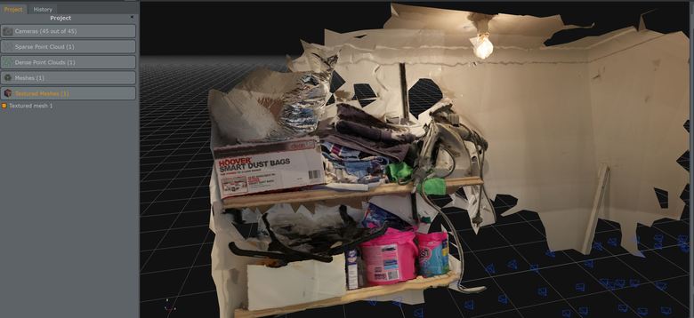 . I have a fast machine with 32GB of ram and old but good GPU. At some points I could not use my desktop because computing was taking a lot of memory and processing power If skydio system can create this resolution and compute such a complicated task on a drone processor or on its controller that is really impressive. Just remember it is only 45 images at 50 mp showing well much less than 1% of all surfaces that would be require to capture my property. If at rough estimation it is less than 0.5m3 it is 1/800 of all space. |
||
| Post 11 • IP flag post | ||
|
WGAN Forum Founder and Advisor Atlanta, Georgia |
DanSmigrod private msg quote post Address this user | |
Quote:Originally Posted by Wingman Was it a GeoCV tour that mashed up 3D aerial with 3D interior? For example, in from this WGAN Forum discussion: ✓ Aerial 3D Models with Drone Deploy for GeoCV Quote: Originally Posted by @Metroplex360 Best, Dan |
||
| Post 12 • IP flag post | ||
|
WGAN Forum Founder and Advisor Atlanta, Georgia |
DanSmigrod private msg quote post Address this user | |
| Nearly two weeks ago I wrote: Quote: Originally Posted by @DanSmigrod I have not heard back from Skydio Media Relations yet. Dan |
||
| Post 13 • IP flag post | ||
|
WGAN Fan Club Member Queensland, Australia |
Wingman private msg quote post Address this user | |
Quote:Originally Posted by DanSmigrod No, it is this one. I have found it by searching "nytimes" on the forum. https://rd.nytimes.com/projects/reconstructing-journalistic-scenes-in-3d The quality we will probably need for what we do is there but it is very slow on a pc with just 8GB of memory and an old GPU. I bet it is quite big in size and this is just one room. So for a whole property it can be very huge. |
||
| Post 14 • IP flag post | ||
|
|
remaxvictory private msg quote post Address this user | |
| I emailed Skydio 4 times asking for an example of an interior scan or a 24 hour trial and finally got this response: We still do not have a trial period for 3D Scan however I'm happy to connect you with a rep. who can walk you through the purchasing process! Check out our Sketchfab page here! The examples aren't houses per say but do give you an idea of 3D Scan's ability. Let me know your thoughts and I'd be happy to help! |
||
| Post 15 • IP flag post | ||

|
Expertise private msg quote post Address this user | |
| Dear Skydio rep. It is Per se. |
||
| Post 16 • IP flag post | ||
|
WGAN Forum Founder and Advisor Atlanta, Georgia |
DanSmigrod private msg quote post Address this user | |
| Video: Faster, Better, Safer. Supercharging Construction with Skydio 3D Scan | Video courtesy of AUVSI YouTube Channel | 24 June 2021 | ||
| Post 17 • IP flag post | ||
 WGAN WGANFan Club Member Perth AUS |
schaferu private msg quote post Address this user | |
| Hehe, if one buys into Moore's law of computing, imo we can be assured that in the not too distant future, interior autonomous capture compatible with MP cloud will become a reality, whether we like it our not. And again, an industry game changer which will require rethinking of sales models, even for MP. Once the outcome of such a capture provides reliable quality every single time, we have reached mainstream. 2 years max I feel. |
||
| Post 18 • IP flag post | ||
Pages:
1This topic is archived. Start new topic?