


Dome - can camera see height - is there a limit?11797
Pages:
1
|
SpencerLasky private msg quote post Address this user | |
| This might be a funny question - I've done a number of scans but the old bank building I just finished had about a 3 story high dome in the center of the room. of coure I scanned it from all angles - multi points in the main room and edges - will photogrammetry kick in? the last thing I did was a 360 still just in case and I noticed there it was not covering the dome it was blurred at that zenith. Thanks this will take a while to get back due to it being 300 points so any good news is appreciated it will probably take 24hrs to get back. Spencer |
||
| Post 1 • IP flag post | ||
|
|
SpencerLasky private msg quote post Address this user | |
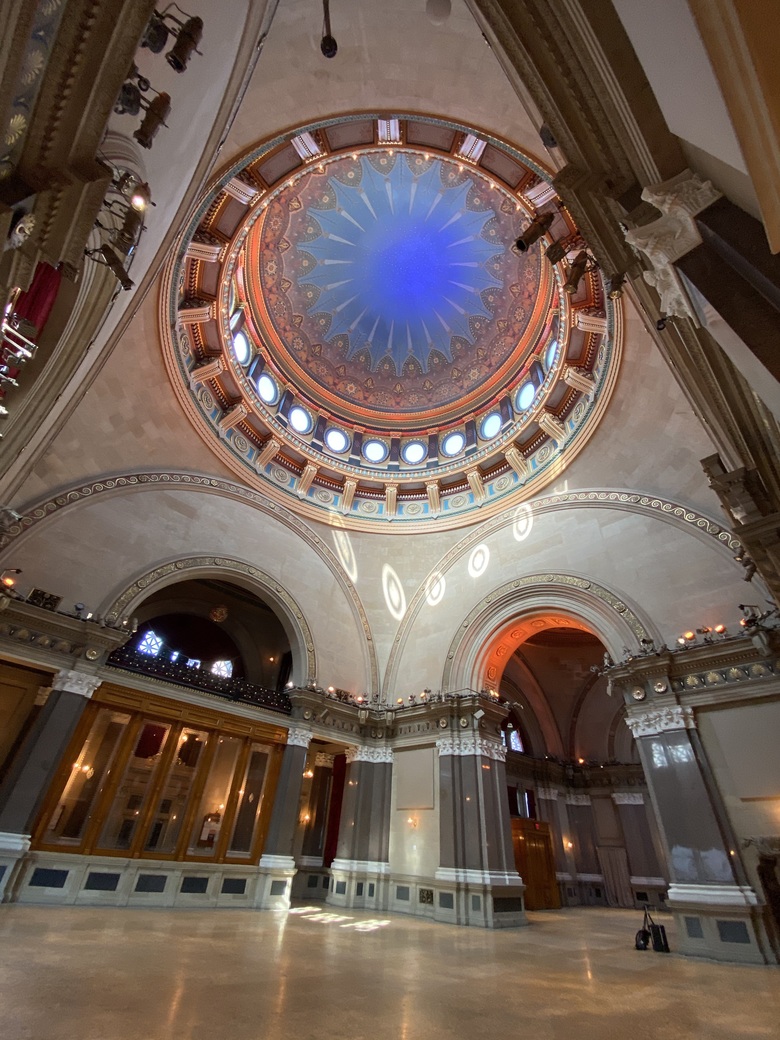 here's a image for better illustration - I think it's going to be fine but ... oh god I hope so that was a solid 12hr day shooting this space ! |
||
| Post 2 • IP flag post | ||

Houston |
briangreul private msg quote post Address this user | |
| My guess is no.... it won't work. But others with more experience may have more reassuring words for you. Essentially, the camera is a ganged array of smaller cameras. There is an infrared projector that puts out little dots.... they are calibrated along radians (think Trigonometry). They overlay the images the sensor reads back. By analyzing the distance between dots it can calculate how far away something is. If you do this with multiple images you can reconstruct a 3D model. The IR dots are a more elegant way of establishing mesh points. It can be done with just the images... see Drone Photogrammetry / orthographic maps. (I think I have my $2 words right). In Matterport, one camera array seems to point forward, one points up, and one points down. It seems to be very accurate under 8 to 12 feet and gets fuzzy the further away you are. This is why in a large room it can't accurately resolve something far away ( like a window or mirror that you want to mark.) As best I can tell, each Pano is a set of 18 IR overlayed images. 6 up, 6 straight and 6 down. There is some overlap on them. Back to your issue, I think the dome is too far away for you to see it. The "fix" would be one of those elevator carts and taking scans every 10 feet up or so until you got in the dome and then scanning up in there. This is assuming that the evil elves (programmers) at Matterport didn't insert some sort of "safety" into their code to prevent photogrammetry of tall objects. There are some scenarios where the code might churn for a long time on buildings that are edge cases.... think about an Atrium building. A good photogrammetry soluion would be taking straight up photos and having them worked into the mesh, but that's not an option for Matterport. I think it might freak if you turned it 90 degrees and let it scan. I think MP is "tuned" to handle 30 foot ceilings or lower. They casually touch on this with their article about very large industrial spaces. They suggest that you should scan the perimeter and do 360 photos in the interior of large warehouses. They also point out that the code can get "lost" trying to stitch repeating spaces (Hotel Hallway of identical doors). They don't say it quite that bluntly. Maybe I'm wrong... this is just my thoughts on it as someone with an IT background who has also done programming. I also did a very deep dive into Occipitals stuff last year and Pix4D for photogrammetry. A large space like this could probably be done with a drone, if you trusted it to stay still in there. They are not always well behaved indoors and prop guards are a wise addition. The problem is that Matterport is not a calibrated point cloud from what I understand. So you can't simply export the MP of the "normal" parts of the building and marry it to the photogrammetry portion you built elsewhere. This is a great use case where Matterport is going to have to grow up if they want to be in the Enterprise space. Commercial spaces regularly have large interior areas and it's something that MP doesn't seem to handle well. IMHO, MP was engineered for residential listing tours. It can be adapted to a bunch of other things in that form factor, but it lacks valuable features that commercial users will demand. One such example being timed scans. Rough in scan, wall covering scan, finish scan for turnover, 5 year life scans. The ability to be in a model and choose which capture point you want to view. Hugely valuable in space management. Jumping between models isn't an answer here either.... anyway lest I get too far away from your question. |
||
| Post 3 • IP flag post | ||
|
|
SpencerLasky private msg quote post Address this user | |
Hum..... well I dug around in my stuff and here's 40' Grid possible higher and looks ok - I mean you can always find the buzz but looking out like this should work I hope!  |
||
| Post 4 • IP flag post | ||

|
|
SpencerLasky private msg quote post Address this user | |
| Brian I think you are right! So my work around is one of these - any thoughts? 1) Use a 360insta in this capture project file - don't know if I can do that? go in the middle of this space on the same project file capture in ipad and run the insta camera? 2) use a 20' tripod and add a series of cloud points at 20' 3) here's something that might sound insane but I think I can get results out of the matterport even when it's not level - I get lazy and I see it some times in terrible shape but it always seems to work so .. try tilting the camera back 5 to 10 degrees - not far just enough. this coupled with a high tripod or stand is my thought. https://my.matterport.com/show/?m=uoZqTEnesUy thanks and big thanks to Dan I'm going to circle back on this ... so much information I personally can barely keep up with it so thanks Dan! |
||
| Post 6 • IP flag post | ||
|
Houston |
briangreul private msg quote post Address this user | |
| I like #2 the best. That keeps it "in Matterport". It also might be a great idea to reach out to Support. Just channel yesterday and May the 4th be with you! Or get yourself some Chips and Queso and a strong Maragita and Cinco de Mayo while you are on hold. Either support or the drink are likely to put a smile on your face..... my money is on the drink though. Any idea what the height of the dome is? Lastly, another option might be getting someone with a BLK360 to subcontract for you. That's a laser which is a different animal entirely. It will scan that dome, but I have no idea how well it does. The tool hoarder in me likes the idea of owning one. The accountant in me says "not in budget!" |
||
| Post 7 • IP flag post | ||
|
|
SpencerLasky private msg quote post Address this user | |
| Ok I have a bLK360 on hold for another job, exterior walk through nature thing. But I did get through to support at matterport and he basically said you're out of luck, you can burn Palo Santo all you want, but the software is going to read the information the way it wants too and looking straight up you get a blur - end of the story. Having said that I still think all these options are worth trying - I like the idea of a slight tilt - not enough you start to distort but you take the end off. Has anyone solved this, I've read as much as I can and still keep working but I think at some point if you're in a tight space with a high dome you might be out of luck do to the way the software will always put a blur flag when looking straight up. The BLK360 will be problematic as well since it will go through the same software. | ||
| Post 8 • IP flag post | ||
|
Houston |
briangreul private msg quote post Address this user | |
| This is just a limitation / artifact of Photogrammetry. There isn't any data at the Zenith or Nadir (up/down) to stitch... so they just blur it with a blend of the close data. 360 degree photo might be your best option. I've used those to deal with some "all doors meet in the middle" situations. |
||
| Post 9 • IP flag post | ||
|
|
SpencerLasky private msg quote post Address this user | |
| Yes but it still will not get high - maybe I do that tilt trick I wanted to try - maybe that will work at least in a 360 mode sl |
||
| Post 10 • IP flag post | ||
|
|
SpencerLasky private msg quote post Address this user | |
| but yes I agree I have looked at every matteport I can find now and nothing allows you to look straight up so if you have geomertery that puts you in problems as this one does your SOL basically. I think is the answer and thus what matterport said. | ||
| Post 11 • IP flag post | ||
|
Houston |
briangreul private msg quote post Address this user | |
| It's definitely something else they need to address if they want to have a truly Enterprise solution. Most Doubletree hotels are atrium buildings... at least the old ones. Are you really gonna tell their Facilities Team that your product can scan everything but the center of their building for an as-built? That's just one example. Facilities are full of examples like this.... another well known one is the vehicle assembly building at NASA's Cape Kennedy.... tallest building in the World and out of spec/scope for a Matterport Tour due to the unique architecture. You could however capture it with a drone and Pix4DCapture to do the photogrammetry.... because looking sideways, up and down are par for the course in mapping and structure modeling. |
||
| Post 12 • IP flag post | ||
|
|
SpencerLasky private msg quote post Address this user | |
| Is that a product outside the matterport product baseline/solution? The depth of this scan, the side rooms, and hallways and staircases are all part of what makes it valuable as a scan so I'm not want anything that does not work as well as matterprot but I'll look into that solution. Even though matterport is not perfect as in this case - (when geometer of distance from and height of a space cause you to look straight up)for me it is still the best to hand to a client and or to use, as an end user. | ||
| Post 13 • IP flag post | ||
|
Houston |
briangreul private msg quote post Address this user | |
| Pix4D is a European software company that specializes in Photogrammetry.... mapping and by extension models of 3D buildings / towers, etc. It's expensive.... but it works well and they have good support. One day I hope to afford a license. | ||
| Post 14 • IP flag post | ||

|
JonJ private msg quote post Address this user | |
| Hi All, Just an FYI, the blurring that occurs at the top and bottom of each scan is not only a limitation of the FOV of the camera being used. I was board one day and extended my Theta Z1 over a 2 story living room from the 2nd floor walkway overlooking the living room. The camera was completely horizontal and the areas directly above and below the camera lenses were still blurred out. Since the camera was horizontal, these would not have been "blind spots" so, I concluded that the blurred areas were completely added due to the model processing. All that being said...tilting the Matterport camera will not help your situation. Hope this helps! Jon |
||
| Post 15 • IP flag post | ||
|
|
SpencerLasky private msg quote post Address this user | |
| I agree Jon, I've given up hope and feel we are at the threshold of this technology - the option to bring this into a computer and recreate what matterport does with photogrammetry is avail, but at a great cost. We did it for Marvelous Mrs. Maisel when they took a matterport I did plus photogrammetry and a LiDar camera of each set and we made them work on a wrap-around video wall - now we did not have vertical as an issue and I can't go back and check if we solved that for this event - but ... money can solve this. But the matterport and I did just check Cupix and the same. It's part of what is in the software to produce these images and like Brian is saying it's a default knowing the images will not make it to the top - I suppose in theory matterport could put another set of camera's and lasers - another row and at least eliminate this for those times when the geometry of the space dictates that you can't get back far enough to look up and see the detail that is very high. So at some point matterport will fail and we don't think about it until this geometer presents its self and as the guy said on the phone at matterport - it is what it is, that's the limit. So thanks for proving this but also have looking at many matterports the fact every single one blurs when tilted up and the way it does it - I understood it was like a mask that goes on as it comes out of the software and not part of the data going in - so tilting the camera back, like you said, will not work. Unless someone can show me any example of this working? I think does not matter what I so the fact the space does not allow you to step back from the 90' dome - and you have to tilt up - that's it nothing you can do. | ||
| Post 16 • IP flag post | ||
|
|
SpencerLasky private msg quote post Address this user | |
This is the option you get and any further tilt-up you get the blur bug. That's full tilt up. Now I guess the only workaround is to do put a tag up on the dome and let it open a still image or they have cool movies too that I can add - they have millions of photo's of the dome - I could also offer my services shoot some killer high res stuff. Maybe get the phase one back and shoot that 100mp to see what super resoluation will do for them - just as a way to apologize which I feel I'm going to have to do now, should of know the limits!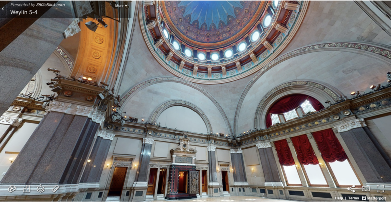 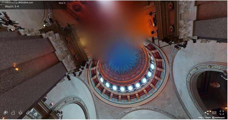 |
||
| Post 17 • IP flag post | ||
|
|
SpencerLasky private msg quote post Address this user | |
| One caveat - it seems iguide possile has found a way to not put that blur in? I've looked at many of there scans now. Does anyone know about this system? Anyone use it? https://unbranded.youriguide.com/vS393GQWCVG8D1 https://goiguide.com/gallery |
||
| Post 18 • IP flag post | ||
|
|
SpencerLasky private msg quote post Address this user | |
| I'm adding to this link at risk of too much texting - but not I'm seeing something new, this model some one else did and has a big outside area - courtyard they walked across - I'm wondering if this is BLK360? If you look up you don't get that blur buzz. https://my.matterport.com/show/?m=HhDGBWXuBEE |
||
| Post 19 • IP flag post | ||
|
|
SpencerLasky private msg quote post Address this user | |
| Note I saw the shadow - it is a BLK360 so I guess that is the answer - no or little blur, the image quality not as good though and some artifacting. | ||
| Post 20 • IP flag post | ||
|
|
JonJ private msg quote post Address this user | |
| @Spencerlasky, I went back and checked some scans I did with the Theta Z1 in the normal upright orientation and noticed that there was no blurring at the Zenith. Obviously, the image quality is not as good as a Pro2, but it may be an option. JonJ |
||
| Post 21 • IP flag post | ||
|
|
SpencerLasky private msg quote post Address this user | |
| Ok Jon thanks I think what happens is the engine that matterport has built will do specific things for each camera, So if it's a Pro2 they will automatically through on a blur, and if it's a BLK360 they will not and so I guess the Z1 is a no as well. Do you mind sharing a scan with me either here or private so I can see. The quality you thinks is best with the pro2? I do appreciate the quality of it an the fact that is shooting a laser I would think helps with its navigation, this place has a lot of hallways and tiny rooms and full circles that lead back to mainspace. Thanks ! | ||
| Post 22 • IP flag post | ||
|
|
SpencerLasky private msg quote post Address this user | |
| If I use the BLK360 or apparently the Z1 or insta360 one of the smaller 360 camera's can we go through the front doors and get a bit of the outside world? this would create a better dollhouse I would think. Anyone have an example of that with the small 360 camera and ... which one is the bang - quality images is the main thing. Thanks ! |
||
| Post 23 • IP flag post | ||
Pages:
1This topic is archived. Start new topic?