


NCTech and KOREC launch KlearView360° to ID assets, defects or changes11097
Pages:
1
 WGAN Forum WGAN ForumFounder and Advisor Atlanta, Georgia |
DanSmigrod private msg quote post Address this user | |
| Media Release --- 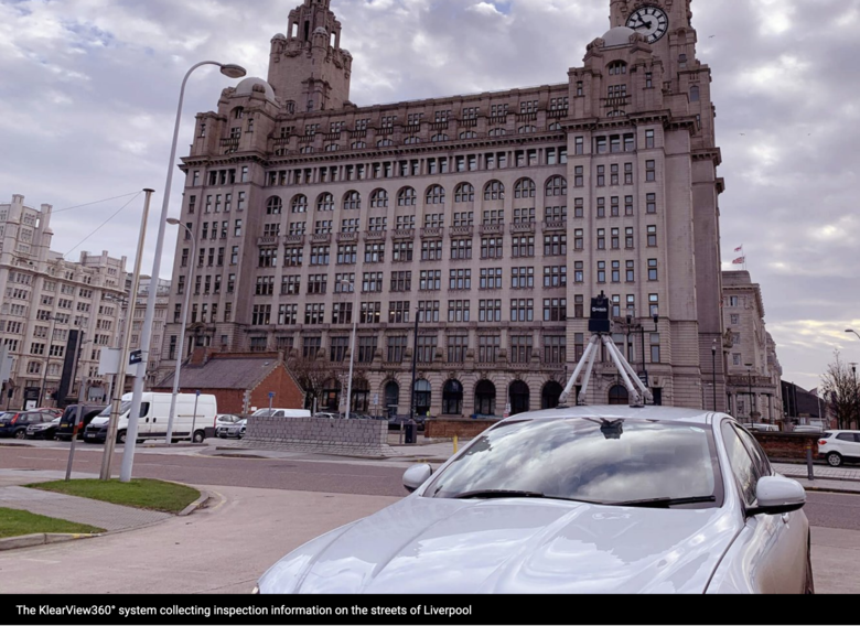 Screen Grab courtesy of NCTech KOREC and NCTech launch KlearView360° Companies join forces on vehicle-based visual asset inspection and verification system KOREC and NCTech today announced the launch of KlearView360°, a streamlined, hosted system designed for the identification of assets, defects or changes within images collected by vehicle or backpack. A cost-effective solution, KlearView360° makes vehicle-mounted asset inspection accessible to local authorities and many others. The system is a joint partnership between the two companies, combining NCTech’s iSTAR Pulsar+ high resolution camera for capturing 360° imagery at carriageway speeds with KOREC’s K-Portal cloud-based hosting solution for live progress monitoring of a project and the assignment of work orders. KlearView360° also enables work management instructions to be communicated to mobile workers for issue resolution via KOREC’s K-Mobile data capture software, designed to run on Android, iOS or Windows devices. Accessible through a standard web browser, the system minimises impact on existing IT infrastructure and is simple to implement. A 360° solution for 360° imagery The KlearView360° workflow has been designed with simplicity in mind, eliminating the need for costly additional hardware and software or extensive training: ✓ Drive chosen route ✓ Identify asset defect or issue from imagery ✓ Assign location with image of asset defect to mobile worker ✓ Mobile worker navigates to asset ✓ Mobile worker undertakes designated task ✓ Mobile worker sends photo verification of work done ✓ Database automatically updated KlearView360° also offers a cost-effective and simple way to add the iSTAR Pulsar’s high resolution 360° imagery to existing GIS datasets hosted within ArcGIS or QGS via K-Portal’s dynamic link, and provides rapid video playback to review driven routes. "Historically these types of solutions have been very expensive, but the KlearView360° integration with the iSTAR Pulsar+ means that we can put vehicle mounted inspection into the hands of local authorities, highways engineers and consultants, utilities and many more in an affordable and effective way.” -- Richard Gauchwin, KOREC Business Area Manager – Mapping & GIS "We’re excited to be working together with KOREC on KlearView360° – combining our unique capability to deliver high resolution 360° image capture on the move at an affordable price point with the efficiency and simplicity of K-Portal. This partnership embodies exactly the kind of relationship that we are keen to form with software and hardware companies throughout the GIS and AEC sector." -- Cameron Ure, CEO of NCTech About KOREC KOREC brings innovative survey and mapping technology to market including the most advanced GNSS, mobile mapping, 3D laser scanners, UAS and total station solutions available to geospatial professionals. The company is a leading distributor of Trimble, senseFly and GeoSlam instruments and has its own in-house software development division. KOREC serves the UK and Northern Ireland through its offices in Dublin, Craigavon (NI), Liverpool and Huntingdon. www.korecgroup.com About NCTech NCTech is a virtual data company, offering an all-encompassing solution which features an interplay between data capture, formation and interrogation. Our capture products lead the industry and enable our layered data services, which provide a fully realised virtual world through machine learning and AI. Working with global partners, we aim to make the creation and access of virtual worlds possible for everyone. Source: NCTech and KOREC # # # # # Related WGAN Forum Discussions ✓ 2020 is the year of Google Street View Blue Line Map Updates by Pros ✓ 9 Rooftop Car Mounts for 360º Cameras for Google Street View ✓ 10 Backpacks to pair with 360º Cameras to create Google Street View ✓ GSV Pricing>NCTech iSTAR Pulsar versus Insta360 Pro 2 and Labpano Pilot Era |
||
| Post 1 • IP flag post | ||
|
WGAN Forum Founder and Advisor Atlanta, Georgia |
DanSmigrod private msg quote post Address this user | |
| Hi All, Demand for Service Providers will increase as a result of technologies alliances like this one between NCTech and KOREC. If you decide to invest in the NCTech iSTAR Pulsar for Google Street View map updates, it is nice to know that NCTech is helping increase demand for its tech via alliances like this. Your thoughts? Best, Dan |
||
| Post 2 • IP flag post | ||
 WGAN WGANStandard Member Cayman Islands |
Harrycayman private msg quote post Address this user | |
| Yes always looking forward to more opportunities | ||
| Post 3 • IP flag post | ||
Pages:
1This topic is archived. Start new topic?