


2020 is the year of Google Street View Blue Line Map Updates by Pros10747
Pages:
1
 WGAN Forum WGAN ForumFounder and Advisor Atlanta, Georgia |
DanSmigrod private msg quote post Address this user | |
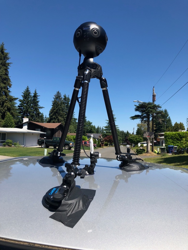
| WGAN-TV How to Make Money With Google Street View with Charles Armstrong (31 May 2018) WGAN-TV NCTech iStar Pulsar at 2018 Google Street View Summit with NCTech Imaging Co-Founder and CTO Neil Tocher (31 May 2018) WGAN-TV Short Story: NCTech Technical Sales Director Andrew Baddeley at the 2019 Street View Summit on the iStar Pulsar Backpack and Roof Mount (Wednesday, 25 September 2019) WGAN-TV Pisoftech's (now known as Labpano) Jeffrey Martin at the 2019 Google Street View Summit on The Pilot Era 360 Camera (30 September 2019) Video: Insta360 Pro 2 Unboxing + Buying Guide + FREE Battery Charger Bundle | Video courtesy of CreatorUp YouTube Channel (5 October 2019) -- 2020 is the year of Google Street View Blue Line Map Updates offered by Service Providers Hi All, Take your pick! The result is the same: ✓ 2020 is the year of Google Street View Blue Line Map Updates offered by Service Providers ✓ 2020 is the year of charging by the mile for GSV Blue Line Map Updates ✓ 2020 is the year that Service Providers Add On a 360º camera solution for miles of capture ✓ 2020 is the year of exponential growth in Google Street View Blue Line Map Updates My prediction for 2020 is based on three things: 1. the growing importance of Google Street View "blue lines" and Google "map updates" 2. the ease of use and quality of 360º capture with solutions seamlessly integrated with GSV 3. the reduction in cost for 360º capture for Google Street View Adding Blue Line Map Updates to Google Street View In June 2016, Google replaced “arrow navigation” in Street View with a smoother “blue line” that allows users to swipe and scroll through images more quickly. And, just this month - December 2019 - "Google Maps has now photographed 10 million miles in Street View ... [and Google Earth imagery] where 98% of people live." That's in just 12 years since Google launched Street View. Organizations willing to pay for Google Street View Map Updates include: ✓ Storefronts (retail, restaurants, other) ✓ Ski Slopes ✓ Parking lots ✓ College campuses ✓ Multi-Family Homes and Apartments (particularly new communities/developments) ✓ Travel and Tourism Destination Marketing Organizations (DMOs, CVBs) ✓ Economic Development Agencies ✓ Utilities (telephone poles, for example) ✓ Parks ✓ Historic districts Solutions for Google Street View Blue Line Map Updates At the 2017 Google Street View Summit in Tokyo, Google announced their Google Street View Ready Standards for 360º cameras and platforms to seamlessly add and update Google Street View blue lines. At the same conference, 18 360º cameras, hosting platforms or software announced that solution was either Google Street View Ready or would be shortly. What was only possible either with a Google Street View car or Google Trekker is now possible for thousands of dollars instead of hundreds of thousands of dollars. Today, there are at least three viable 360º camera solutions for professional real estate photographers to add to their toolbox. 1. NCTech iSTAR Pulsar 2. Insta360 Pro 2 3. Labpano Pilot One 4. Ricoh Theta Z1 5. GoPro Max + TrailBlazer from Panoskin The likely early adapters to buy these Google Street View Ready cameras are: 1. Matterport Service Providers that were the "first" or "among the first" Matterport Service Provider in their market; but today have many competitors driving down price (until the demand for Matterport tours increases). And, are seeking a competitive advantage 2. 3D/360º photographers seeking to be "first" or "among the first" to offer GSV map updates 3. Geeky photographers that are Solopreneurs While it is relatively super-easy to do Google Street View blue-line map updates with the right gear I could imagine that it will be at least a couple of years before gig drivers for Uber-Lyft-Grubhub-Door Dash-Amazon-Postmates - can afford - and figure out that they are the ideal candidates for buying and configuring their cars with these camera. This means there is an entrepreneurial window of at least a couple of years to invest in the gear, set relatively high prices and take advantage of first mover advantage in their - your - market. I could imagine that the barriers to entry to gig drivers - cost, configuration, sales experience and subject matter expertise - are the same reasons for WGAN Community Members to get started sooner (than later) with investing in Google Street View Blue Line Map Updates Gear; gain experience and leverage that experience to scale the business before gig drivers figure-out the opportunity. What's Holding Me Back For more than a couple of years, I have been a great candidate - including what I learned first hand by attending the Google Street View Summits in 2017 (Tokyo), 2018 (San Francisco) and 2019 (London) to add Google Street View Blue Line Map Updates. My three (personal) objections to getting started will likely be over-come in 2020: 1. Gear Configuration 2. Workflow: Easy of Use 3. Total Investment in Gear and Accessories Gear Configuration One of the challenges when you dig deeper is figuring out exactly what gear you need beyond the camera: 1. Car mount (and will it work on my car?) 2. Backpack mount (and is it too heavy for me?) 3. Batteries 4. Car power adapter 5. Cables, brackets 6. GPS (I prefer a solution where GPS is included: not a separate piece of gear) 7. Case for camera and related gear 8. Warranty 9. Customer Support (Extra charge?) 10. Repair (what happens when there is a scratch on a lens?) Workflow: Easy of Use I seek an Apple-like it-just-works experience: from image (and data?) capture to uploading to Google Street View directly (or, at least, without having to upload to my computer first.) For clarification, I just want to "plug" the camera into WiFi at the nearest Starbucks with high-speed Wi-Fi (or 5G) and have the upload to Google Street View happen magically without any (or little) action on my part. I would like the image capture (and data?) experience to be super-easy. It's likely that too many settings options - choices - likely would confuse me. Not all solutions offer these features (on my wish list): ✓ no computer necessary ✓ shoot 3+ hours of video without stopping the recording (media storage and heat) ✓ interval of shooting adjusts for speed of travel (walking, biking, driving) ✓ in-camera stitching ✓ 1-click uploading to Google Street View ✓ GPS built-in Total Investment in Gear and Accessories The WGAN team prepared a Google Sheet - WGAN Google Street View Blue Line Map Update | Nicely Loaded Cameras, Gears and Accesories Pricing Comparison - to help the WGAN Community get a handle on comparing the cost of these solutions. Private Message me for access. Subject Line--> WGAN Google Sheet-Compare Camera Pricing 1. NCTech iSTAR Pulsar 2. Insta360 Pro 2 3. Labpano Pilot Era 4. Labpano Pilot One 5. Ricoh Theta Z1 6. GoPro Max + TrailBlazer from Panoskin We excluded: 1. solutions not designed to easily capture one mile of streets 2. earlier generations of the same camera 3. entry level Google Street View Ready cameras Of course, each solution also has it unique position in the space. Some factors include: 1. 360º image and stitching quality 2. Data capture in addition to 360º image capture 3. Camera and lenses protection 4. Easily capture a mile of Google Street View 5. No computer necessary 6. Processing 7. Pricing 8. Workflow 9. Accuracy of location data 10. Removable data storage 11. Removable battery 12. GSP module built in 13. How the camera deals with heat over extended use My initial thinking on client pricing is: $X First Mile $X each additional mile (varies by car, bike or walking). You might add via drone, skateboard or hoverboard. $X Travel outside of radius of X miles of Atlanta Here's how one WGAN Member charges whom offers "Street View Ready Pro Grade" using the NCTech iSTAR Pulsar ... 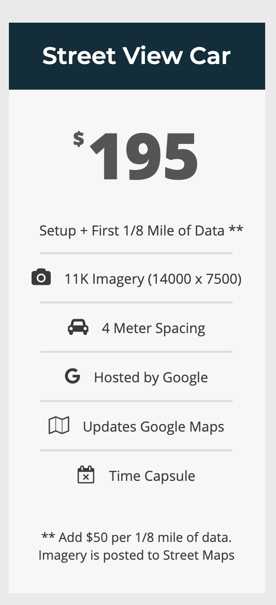 Screen Grab courtesy of Metroplex360 It's likely that I would use the rate card internally to configure cost and quote a fixed price per project. What are some of the questions that you are struggling with as you think about investing in Google Street View Blue Line Map Updates? Happy New Year, Dan P.S. Fun Fact: We Get Around Atlanta was the first Matterport Service Provider to charge by the square foot when we bought a Matterport Camera in July 2014. Before then, Service Providers charge by the number of 360s. WGAN Related Forum Discussions ✓ WGAN Forum discussions tagged: [NCTech] iSTAR Pulsar ✓ WGAN Forum discussions tagged: Insta360 Pro 2 ✓ WGAN Forum discussions tagged: [Labpano] Pilot One ✓ WGAN Forum discussions tagged: GSV17, GS18, GSV19 ✓ Labpano Pilot One pairs with Pilot Tour Offers Automatic Positioned Images Additional Resources ✓ www.NCTechimaging.com ✓ www.Insta360.com ✓ www.Labpano.com ✓ Google Street View Ready Pro Specifications ✓ Google Street View Ready Cameras Video Transcript (Video 1 of 2 from Top) - Hey, I'm Dan Smigrod, founder of the We Get Around Network Forum. Today is Thursday, May 31, 2018. We've just finished the second day of the 2018 Google Street View Summit. With me today, hey Charles, good to see you. Charles Armstrong is Product Manager, Google Street View. What an amazing conference! - Thanks. - Really awesome! It's always exhilarating to be at a Google Street View Summit, very exciting! For our We Get Around Network Forum members, I think the key question is, "Okay, learned a lot, but how do I make money?" - Yeah. - So what is your take-away for Google for our Community of photographers how to make money with Google Street View? - I'd say a few years ago, just to take a step back for a minute, the focus was really on simplifying the workflow so that you could get in and out with businesses and photograph them a little more efficiently. What we've seen in the last year or two is that we're now trying to help these photographers and these agencies serve chains and you know large groups of businesses in short order. What we're seeing now and this comes down to the fact that there's greater demand now. There's a growing demand that we haven't seen before. And yet the photographer base is growing linearly while this market recognition of 360 imaging is really growing exponentially... is an opportunity for these photographers to serve much, much larger bases. So we've been rolling out the necessary tools and infrastructure to support photographers who can sell at a DMO, that's a Destination Marketing Organization scale, or a city scale or a state scale. The potential is there at this point. And the organizations themselves are excited. They're ready to get on Google Maps! With the support for things like driving around with these cameras and having businesses and street signs and speed limits and addresses automatically extracted from the imagery, these photographers are able to sell more than just virtual tours now. They're able to sell [GSV] map updates. And we think that's going to help them sell at scale. - That's really terrific. I think one of things I was blown away with is probably half the audience was related to visitor and convention bureau, tourism bureau, economic development. - Yup. - And these are organizations that want to have current Street View photography, both on the street and actually for their members or the businesses. - It was a shift for us this year. So historically, we've really tried to and we would love to continue really invite in the photographer community. But there, what we're creating is sort of a push through industry. And instead this year, we took a different approach. We said let's really invite the customers. Let's get them excited. And that way they're creating pull through. And a good industry has both. It has the push and the pull simultaneously. - Well, I think if we were having this conversation three years ago, in fact, we had this conversation three years ago. - We probably did. - So this is actually exciting Before, perhaps it was about the cameras and the technology, and as you talked about, the workflow. Part of what we saw at this conference is that there are now I don't know whether we call them cameras or data capture or cameras and data capture into? - 360 cameras usually, but I agree that they are becoming more than that. That's still the term that most people are using. - So but think about there's now cameras that enable scale of shooting. - Yeah, it's true. - Not by the square foot, but by the mile of data capture. And that's really crazy, isn't it? - Well I think you were early on the boat to think about selling, or at least the concept of selling virtual tours by the square foot. I thought that was really a brilliant move. What we're seeing here, as to your point, is monetizing this coverage on a mileage basis. And that's really exciting. In the end, that's what everybody cares about is how much of their world is represented, how much of their town, their city, their state, whatever. - Yeah, so I think that what we're going to start to hear in the We Get Around Network Forum is talk a lot about how to make money with Google Street View. We're getting to the point where the demand for content is going to exceed the supply of photographers. And for those photographers that figure out how to embrace the new tools that enable capture at scale will have a competitive advantage. And we'll get more into that, but I thought it was really helpful to be able to hear Charles first-hand talk about both the exponential growth that's coming in this space and yet, at the same time, the photographer population is really something that's linear. - Yeah the writing's on the wall. The next couple of years are really critical. It's not about I just want to point out, it's not about abandoning all of the investment that we've done as a community to support internal interior photography and these tours. The combination is really where we're headed. And we are seeing great interest from these large organizations. Now it's interfacing between the established professionals and these organizations to make sure that they're speaking the same language and monetary exchanges can happen. - Yeah so very exciting, thank you, Charles. We've been visiting with Charles Armstrong, Product Manager for Google Street View. I'm Dan Smigrod, Founder of the We Get Around Network Forum, finishing up day two. Time for the after-party! Thanks for tuning in to WGAN-TV from San Francisco. Charles, ready for the party? - Sounds good. ---------- WGAN-TV The Future of Google Street View with Charles Armstrong (31 May 2019) Video Transcript (2 of 2 from the top) - Hi, I'm Dan Smigrod, I'm the founder of the We Get Around Network Forum, today is Thursday, May 31, 2018, and we just finished day two of the 2018 Google Street View Summit. With me, hey Charles, good to see you again. - Pleasure. - Charles Armstrong is Product Manager of Google Street View. - That's right. - What an amazing conference. - Thanks. - Two full days, really exhilarating and exciting, we've been in the moment about Google Street View today, but what does the next ten years look like for Google Street View? - Well, it was an honor to have Ray Kurzweil speak yesterday, he's quite the visionary. Seems to really have a good understanding of the pace at which society is advancing. And I walked away with three pillars of advancement that are likely to converge in the next five to ten years. One is the ability to scan the world's surface at a very high degree of fidelity. The second is the ability to analyze that data in a way that gives us a semantic understanding that can really be then cross referenced with our own personal interactions in the world. And the third then is to be able to represent that in new, augmented ways, that really interact much more intimately with our own sensory perception, so it's a lot of augmented reality, and high accuracy understanding of the world, but the combination of these things and machine learning coming together are going to be transformative. I am convinced that the next five to ten years will see us interacting with the world in pretty profound new ways. - Well I think one of my take aways of hearing Ray talk is about how technology is progressing at an exponential rate, not at a linear rate. Do you wanna may be comment of how that exponential ties back to those three things? - So we're seeing, we're seeing these advancements in the camera technologies improving across pixels and resolution, we're seeing greater pose confidence and geometry reconstruction, and a better semantic interpretation of things like storefronts, and reading signs, and understanding the spirit of what they stand for, that's pretty profound. Machine learning is making this all happen at a pace that is fairly un-intuitive for the human mind to wrap our heads around. As Ray explained yesterday, we can't help but project into the future in a very linear capacity, it's how our brains are wired. But that's not what's happening. If you look back 25 years, that period of progress is much more profound in terms of what we've accomplished compared to the century before it, and the next ten years, we'll accomplish more than the previous 25. Wrapping your heads around that means you've really gotta start to predict in a very unnatural way, how these technologies will converge, how these advancements in cameras and machine learning and sensory adaptation can be leveraged and will be leveraged, whether we're ready for it or not, there will be advancements that will bring that to us. And so it's exciting to discuss with these very influential people at the Street View summit what we can do to be ready for that. - I think I got a little taste of the future for me, when driving in an Uber car, that the street view announced to the driver to turn right after McDonald's, and I hadn't heard that before in Atlanta, and that to me was the artificial intelligence, how to tease out of that imagery, that that's a McDonald's and the next part is to turn. And I think that was the beginning of this exponential growth, when you talked about the quality of the imagery growing exponentially and that the semantics that the artificial intelligence apply to that image-- - That's the magic. - It's the magic, growing exponentially. - So today it says turn right at McDonald's, it understands that that's a very familiar construct to you. But in a few years, it'll say things like, you might wanna pull over here, they've got the Happy Meal prize that your daughter really likes, and you know, while you're at it, keep in mind that you've earned the bonus bucks, or you have the coupon that your aunt gave you, you might as well use it. I don't know why we're picking on McDonald's here but that greater and deeper understanding is possible again when you compare that personal graph and the social graph, and you can only do that when you have an intimate understanding of both. - Yeah, so very exciting, thank you for sharing that Charles, it's good to see you. I'm Dan Smigrod, founder of the We Get Around Network forum, reporting for WGAN-TV, in San Francisco. Charles, time to head to the after party. - Sounds good, thanks. - Good to see you. --- Video: Insta360 Pro - Google Maps Street View ready | Video courtesy of Insta360 YouTube Channel (14 February 2018) Video: camera 360° - The Pilot Era - tutorial review | Video courtesy of Michael Kolchesky YouTube Channel (4 March 2019) Video: Labpano Pilot One 8K: Kandao Qoocam 360 8K competition or mini-me Pisofttech Pilot Era? (Video courtesy of Sarb Johal YouTube Channel (27 December 2019) From WGAN Forum discussion: ✓ [R&D] Using the Insta360 Pro for Google Street View Quote: Originally Posted by @TosoliniInsta360 Pro Camera  Screen Grab courtesy of Labpano (Pilot Era 360º Camera with rooftop mount) |
||
| Post 1 • IP flag post | ||
|
|
ambientar360 private msg quote post Address this user | |
| Thanks Dan, Happy new year to all, Very complete, interesting information and very useful to think about it and start planning a new business. Regards, Luis |
||
| Post 2 • IP flag post | ||
|
WGAN Forum Founder and Advisor Atlanta, Georgia |
DanSmigrod private msg quote post Address this user | |
| @ambientar360 Please let us know what you decide. Hi All, Got a public rate card on what you charge for Google Street View Blue Line map updates? Please share to this WGAN Forum discussion. Happy New Year, Dan |
||
| Post 3 • IP flag post | ||
|
WGAN Forum Founder and Advisor Atlanta, Georgia |
DanSmigrod private msg quote post Address this user | |
| Hi All, A WGAN Member writes ... Dan ---- Dan, I've been following your year-end posts with great interest. I've been wanting to jump into the GSV arena for quite awhile. I've been diverted by doing so with a huge surge of business last year in real estate & vacation rentals. I need to diversify. But more importantly, I need to have more than a passing knowledge of this area. If I could be confident that I could get some great clients (not the store-by-store one-offs for business listing tours), I would gladly purchase the equipment and get going with it. (NC Tech seems the best solution for the area here). I would love to interact with someone who is in the growth phase of providing this service to see how best to move forward. I've even thought of pitching to condo Homeowners Associations to do GSV tours that would include the amenities of their condos. Our local municipalities have very spotty coverage of recent GSV photography - some as recently as 2 years ago - some well over 10 years. Thoughts? Help??? [redacted] PS: All the best for a great 2020 |
||
| Post 4 • IP flag post | ||
 WGAN Fan WGAN FanClub Member Queensland, Australia |
Wingman private msg quote post Address this user | |
| I am just curious, why some put a camera so close to a roof car while others try to elevate it? Those who put it too close are picturing a lot of a car roof space while elevated cameras should capture more road surface. It's almost like it does not matter how much of surrounding you are capturing as long as you can see forward/backward and on sides. While I am waiting for my new Pilot Era to try to do a street view I am wrecking my brain where to get as small car as possible. My car is a van(Nissan Elgrand) and its roof is huge but the front(bonnet) is a really small. I can use my wife's car(nissan dualis +2) which has much smaller roof but it is not that much shorter(long bonnet) in a car length. Can someone tell me if either of my cars can work if I elevate my camera 30-50cm above the car roof? Another question is the mount. I have no special one designed for it but I have this one for my GNSS antenna. 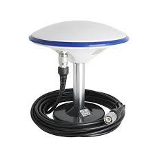 The bottom of it is a super strong magnet but its rod is too short and about 120mm long. If I extend it(threads on the rod are 5/8 males) or make a new rod about 30-50cm long do you think it will hold about 500g camera? I can try to get three of these magnets and built a three arms system but do I really need three point roof connection considering I am not going to drive with speeds faster than 60km/h? |
||
| Post 5 • IP flag post | ||
 Tosolini TosoliniProductions Bellevue, Washington |
Tosolini private msg quote post Address this user | |
| @wingman based on personal experience, I don't see a reason to put the camera closer to the roof or you'll get 'too much car' in the photo. Here is what the image of an Insta360 Pro attached to a roof of a Ford truck looks like in GSV: https://goo.gl/maps/8VJWvh7byTtN2GESA 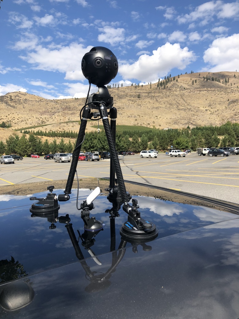 If I could elevate it a bit more, I'd probably do it, but the final outcome is quite acceptable. When we attached the camera on a boat, we had to elevate it as much as possible. So we taped the Camtree gripper to a tripod. 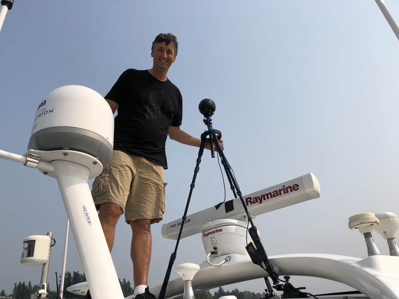 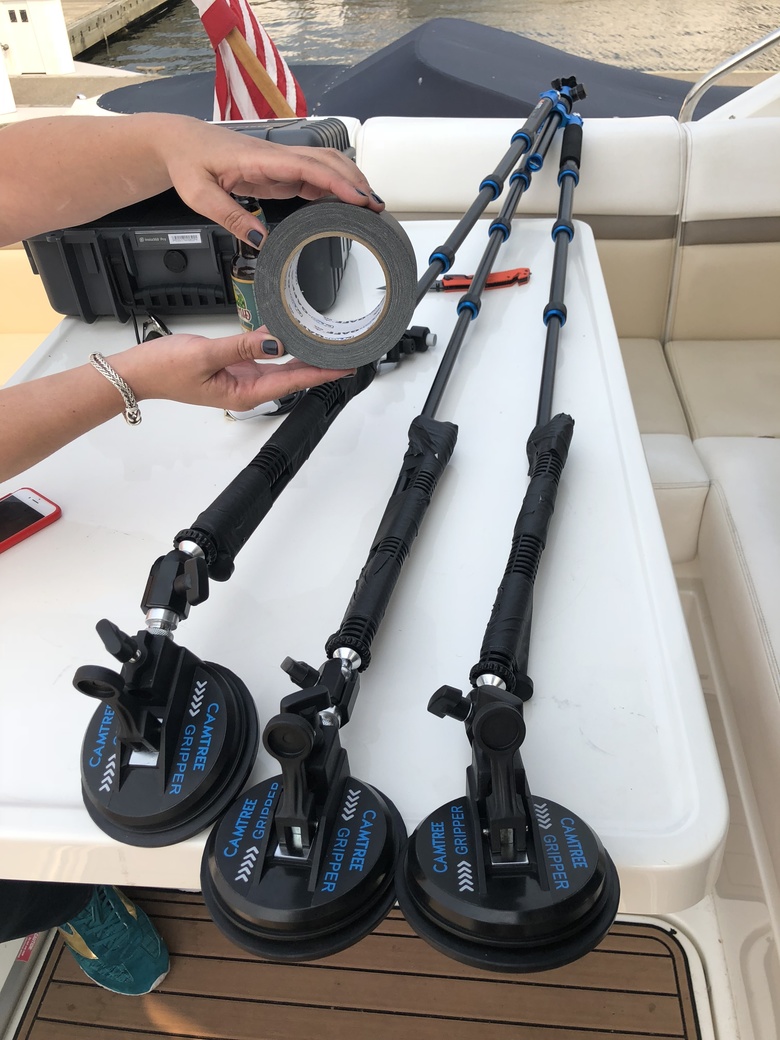 Here is what the final image looks like: https://goo.gl/maps/QvoPizNorFYdPTfq7 And yes, that's Bill Gates's home. |
||
| Post 6 • IP flag post | ||

Kansas City, KS |
Richierichks private msg quote post Address this user | |
| So, if a business needs their "See Outside" updated due to remodeling or being a new business in that location, we can shoot the street and it will replace the existing Google Street View/Maps images? | ||
| Post 7 • IP flag post | ||
|
WGAN Forum Founder and Advisor Atlanta, Georgia |
DanSmigrod private msg quote post Address this user | |
| @Richierichks I apologize for the delay. I missed your post ... Quote: Originally Posted by @Richierichks It depends. I would NOT promise it. If the quality of your video is better; if the length of your video is longer; if the sun-moon-and-the-starts align, your map update may replace the existing Google Street View. And, the older Street View will likely continue to live for those that want to view previous time-line content. Clear as mud? Dan |
||
| Post 8 • IP flag post | ||
|
WGAN Forum Founder and Advisor Atlanta, Georgia |
DanSmigrod private msg quote post Address this user | |
| P.S. Correction. 2020 is the year of the Coronavirus pandemic. | ||
| Post 9 • IP flag post | ||
|
WGAN Forum Founder and Advisor Atlanta, Georgia |
DanSmigrod private msg quote post Address this user | |
| WGAN-TV | How to Publish to Google Street View from Matterport; +10 GSV FAQ Pro Tips for Common Problems (Solved) | Guest: Wingman Media Brisbane Owner Michael Lysov | www.WingmanMedia.com.au | Thursday, 18 July 2024 | Episode: 222 | WGAN Forum Member Name: @Wingman Google Street View Tour with Multiple Floors | Published via Matterport GSV Add On | Tour by: Wingman Media Brisbane Owner Michael Lysov Hi All, A WGAN Forum related topic: ✓ WGAN-TV Transcript: How to Publish to Google Street View from Matterport Best, Dan |
||
| Post 10 • IP flag post | ||
Pages:
1This topic is archived. Start new topic?