


3D Modeling with 'dollhouse' outdoors in full sun. I did it with GeoCV.9750
Pages:
1
 WGAN WGANStandard Member Los Angeles |
Home3D private msg quote post Address this user | |
| Hello WGAN members. You may recall that GeoCV recently announced the additional capabilities of downloading panoramas which you can then process, Photoshop, adjust and re-upload to your models. This works, and here I've taken it one step further as an experiment for an upcoming outdoor project I may shoot. I went out before dawn (you can also do after dusk or a heavily overcast day) and shot the area. As this was a test, I kept it small, just 17 scans. By itself, this would create a flat and pale looking walkthrough experience, but a dollhouse without 'sun' holes. I've done this many times shooting patios, backyards, etc. I expect many of you have. Ain't it fun scanning as fast as you can before it's too dark? But I added some steps. As I shot, I carefully noted the position, height, level and starting compass direction of each pano position. I didn't do this scientifically but eyeballed it as carefully as I could. Then six hours later, about noon, I returned and reshot all 17 panos as "Viewpoints" on GeoCV (their name for shooting a 360° image without point cloud data), matching all the positions and angles as closely as I could. Then I "Reprocessed" the model. When it came back, I downloaded all 17 (dull) scan panos and also the 17 Viewpoint (sunny) panos. Next, I renumbered the set of Viewpoint panos with identical file names to their equivalent dawn/dull panos. then I "uploaded" this set of sunny panos to the GeoCV Editor (as Panoramas, not Viewpoints) and clicked "Reprocess". What you see here is the result. The spacial geometry (point cloud) data remains from the morning pre-dawn scan but all the walkthrough panoramas AND the images mapped onto the point cloud mesh are from the sunny panos shot at noon. Yeah, it's two steps instead of one, twice the shots, but you're actually in control of the process. With Cortex you're wondering if it will figure out where a scan should align, and with no recourse if it fails other than to delete and try, try again. I have devised a way to significantly increase the alignment accuracy (over eye-balling) and have ordered some gear. When it arrives next week I plan to redo this test. The attached photo points out some of the misalignments from my eyeballing technique which come mostly from errors in leveling the camera and the start compass rotational direction. Errors in both these axes can really add up and unlike floor position and height, are hard to eyeball. Note: The chairs in the middle are grouped around a Glass table which contributed to the sub-par furniture images in the center. Hey, not perfect but okay for my first test! 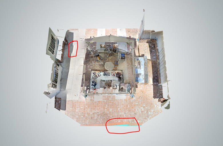 |
||
| Post 1 • IP flag post | ||
 Tosolini TosoliniProductions Bellevue, Washington |
Tosolini private msg quote post Address this user | |
| Interesting experiments that are only possible by accessing the source files and modifying them. This is a core strength of GeoCV over MP. Well done and thanks for sharing some best practices. | ||
| Post 2 • IP flag post | ||
 WGAN Forum WGAN ForumFounder and Advisor Atlanta, Georgia |
DanSmigrod private msg quote post Address this user | |
| @Home3D Brilliant thinking and execution. Way to push the tech in ways that the GeoCV team likely never imagined (and are likely delighted to see). Thanks for sharing your test. Looking forward to the seeing the results of the big shoot. Best, Dan |
||
| Post 3 • IP flag post | ||
 geoCV geoCVDirector of Operations |
sameerak private msg quote post Address this user | |
| Thanks for sharing @Homde3d ! Truly great work with this tour. Bravo. In case anyone was wondering, here is what the tour looked like before reprocessing with the new panos: 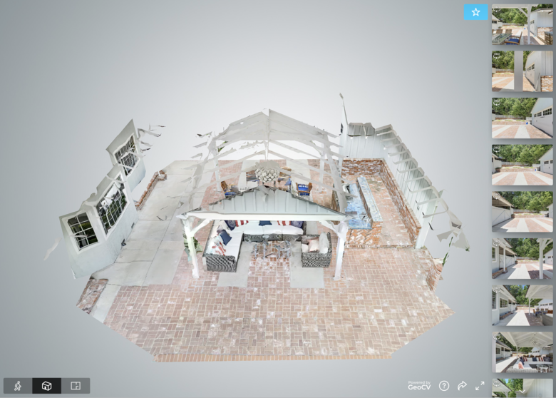 |
||
| Post 4 • IP flag post | ||

|
Jamie private msg quote post Address this user | |
| You could have a plumb Bob suspended from the tripod to give you a more accurate position for the tripod and Leave a sticker or token on the ground. That's easy to Photoshop out. I did that before when I used the mp to create a mesh and then added 360 dslr shots Great job |
||
| Post 5 • IP flag post | ||

|
GarySnyder private msg quote post Address this user | |
| As Jamie has said the best and easiest what to shoot repeat locations is to mark you shooting spot. The way we do it in the film industry is to mark each location of your dolly, rig or tripod. What I do is extend my tripod legs to max and then use some form of tape be it gaffers tape of just masking tape and mark each tripod leg on the hard surface. If you're shooting on the ground then use golf tees and push then into the ground so they sit just under the tripod leg. Finally align the camera straight on to your subject for both shots. If you follow this procedure then both your shots should always align in all 3 ways, height, level and overlay. BTW, this is how many time laps shoots are accomplished over days, months or even years by precisely marking your tripod location and returning to it each time. I hope this helps. This is also fantastic news that GeoCV can combine the point cloud and images shot at different times into a functional VT as well as generate a dollhouse. This is another reason that serious VT/VR producers should consider GeoCv as their first choice for VT/VR production. |
||
| Post 6 • IP flag post | ||
|
WGAN Standard Member Los Angeles |
Home3D private msg quote post Address this user | |
| Overnight I made alignment adjustments using the Photoshop "offset" filter and then re-uploaded and Reprocessed. Model is even cleaner. The process definitely works! This new model simply replaces the first, so the cleaner model is in the same window up above. |
||
| Post 7 • IP flag post | ||
|
|
Jamie private msg quote post Address this user | |
| Or here is another idea. Shoot one 360 scan then switch to the hightlight. Saves marking the location | ||
| Post 8 • IP flag post | ||
|
WGAN Standard Member Los Angeles |
Home3D private msg quote post Address this user | |
| Hi - @Jamie. Perhaps I wasn't clear. The first FULL set of all "scan" panos must be shot before dawn, after sunset, or on a heavily overcast day. These conditions are required for the infrared scanner to capture point cloud data outdoors. The second set, the "Viewpoints" 360° images (infrared not used) were shot on the same positions 5-6 hours later, in full sun. This test was 17 "scans" at 6am, and 17 "Viewpoints" shot at noon. In Matterport jargon, we'd say a "scan" and a "360 photo". GeoCV calls them a "scan" and a "Viewpoint". |
||
| Post 9 • IP flag post | ||
|
|
Jamie private msg quote post Address this user | |
| I've pm'd you | ||
| Post 10 • IP flag post | ||
|
WGAN Standard Member Los Angeles |
Home3D private msg quote post Address this user | |
| I just rec’d the addn’l gear I’m hoping will make this system possible with more speed and much greater precision. I plan to shoot a new test soon. | ||
| Post 11 • IP flag post | ||

|
Convrts private msg quote post Address this user | |
| This is great @Home3D, great way of utilising the benefits of the GeoCV system! On another topic, do you have any tours created in SD by any chance? Just been asked to create a tour of the HCA Healthcare hospital in The Shard in London. It's only on one floor but is a big area and the 200 scan limit will mean it'll have to be broken up if I do it in HD so was wondering what SD looks like? Thanks again! |
||
| Post 12 • IP flag post | ||
Pages:
1This topic is archived. Start new topic?