


360 View and Matterport Pro2 in Capture v.3.0.1 : GPS and 3D conversion8972
Pages:
1|
|
xiarosh private msg quote post Address this user | |
| Hi MPS My current case : Capture app v. 3.0.1 (712.23177) +iPadPro , GPS is On and is working. Looks like Matterport introduced Insta360 ONE X / Ricoh Theta support and lost Pro2 support? Some questions 1 The previous week, I exactly saw all my 360 views were placed onto plan according to GPS coordinate. This week I see some changes in the Capture app, it looks a little bit different (some changes in an interface). No one from 360 views in the last version was placed at plan. As a result – I can’t find how to place 360 View on a plan in Capture, and now I have manually arranged all my 360 views in Workshop only. It means – it is possible only after upload. I tried did this several times, during the day – unsuccessfully. Any ideas? Could you confirm and check this? 2. A new option is available in Capture app – 3D Conversion. I tied to use it – and nothing useful for Pro2. Did you receive try it with Matterport Pro2 on 360 views? Did you see any results of this option? Some additional info Last version at https://itunes.apple.com/ca/app/matterport-capture/id701086043#?platform=ipad 3.0.1 Mar 22, 2019 Summary: • Matterport Capture now runs on iPhones as well as iPads! • 360 camera support: use your Insta360 ONE X or Ricoh Theta V to create immersive 3D spaces using our Cortex AI technology. • Continue creating immersive 3D spaces using the Matterport Pro2, Pro2 Lite, Pro 3D and Leica BLK360 cameras. According support information at https://support.matterport.com/hc/en-us/articles/360000951048-Place-your-360%C2%BA-Views-in-the-Capture-App - It should works . |
||
| Post 1 • IP flag post | ||
|
|
xiarosh private msg quote post Address this user | |
| Hi Could anybody check this issue with 360 views with Pro2 ? Will last Capture app place it on a plan according to GPS coordinate? Thank you in advance |
||
| Post 2 • IP flag post | ||

|
RichardStanton private msg quote post Address this user | |
| Greetings, I can only speak for my own experience but it is as follows: #1 - Hmm to be honest I have not noticed anything different regarding the placement, but I never relied on GPS placement before either. I will play with this too and see if I can confirm what you are seeing too.. As for placing the 360, once you do the 360 scan, it should appear in a round icon on the right / bottom edge of Capture. If you don't see where it tried to place it (maybe off screen) you can touch the image there and it should take you to the 360 view and you can tap on the "Place on Map" link in the upper right of the view. That should bring you back to the map with the 360 highlighted and ready to move. Now, unless you meant something different, I apologize if I did not understand what you are seeing. #2: I use this quite a bit, both with the Pro 2 and the OneX. I mostly use the Pro2 with the feature because it's higher resolution, but I will swap to the 360 for tighter spaces or if I need to pick up speed as it's very fast if I am on a spot filling mission. As for when it's useful - for we whom have a Pro II it's obviously no replacement for a regular scan. It can, however, be incredibly useful for filling in your mesh when light is blinding your Pro II's Infra-red. It can still create the 3D based on the photographic telemetry rather than relying on the lasers. Now, I find it's nowhere near as accurate, but in a well scanned area I have been able to drop in 360's to stabilize spotty mesh issues. In the converse I have also dropped in 360s and had it interpret them so badly that I would end up with a version of the space at a 45 degree angle or something like that... Capies ut pendes, or caveat emptor, pick your favorite latin.. but since a delete fixes that issue quickly I find the risk is worth the reward. Hope that helps at least a little? |
||
| Post 3 • IP flag post | ||
|
|
xiarosh private msg quote post Address this user | |
| Previous week - when I finished scanning inside a house, I added several 360 views from outside. These views were automatically placed by GPS coordinate. I just corrected their placement. After that were 2 updates : 3.0 Mar 21 and 3.0.1 Mar 22, 2019 I found issue with 360 views on 26 Mar. It was exactly this case "however, be incredibly useful for filling in your mesh when light is blinding your Pro II's Infra-red" because I scanned playground outside - I did first 2 scans in 3D and all other in 360 view mode. No one from 360 was automatically placed on a plan in Capture. I especially repeated this at evening 5 hours late - the same situation. All 360 view should be placed manually in Capture or in Workshop. MP wrote: Can 360º View markers be placed automatically? Sometimes. If location and orientation data is available, then Capture will attempt to place the 360º View in what it believes to be the correct location. ; I have some doubts about the meaning of the word 'Sometimes'. IMHO : Sometimes = you can receive results - or cant. No warranty of function, no warnings or indication during a process, nobody knows. it's funny to read about function with 'Sometimes' options in digital equipment. I tried to convert some 360 (from my Pro2)into 3d - it was without success (additional plugin installed). My idea was the same - to use this transformation when I pass thru light-struck spots to avoid wrong 3D data. Maybe you can exactly describe your actions/steps of 360 conversations to 3D? It will useful for many people Thank you ! |
||
| Post 4 • IP flag post | ||
|
|
RichardStanton private msg quote post Address this user | |
| So it is all starting to make sense to me now based on what you have said here and it brings me back to my original understanding of how 360 scans work based on my own empirical testing. Your post got me thinking hard on the last several weeks where I have been testing the Insta360 OneX quite hard in a mixed 360 camera 3D / Matterport Pro II Infra-Red 3D workflow. So, I will state what I believe to be true and dovetail into what works for me in case it is helpful for you or anyone else. 1. 360 Scan placements behave just like a dumbed down version of the 3D placement algorithms. e.g, the placement (or not) of a marker on the map is heavily determined by the quality and confidence in the location data of the device. I say this because I see the same behavior patterns/results outdoors AND indoors, where GPS location could not be a factor in the determination of placement. When on a good day (long distance between scans is easy) I find that the 360's often will place on the map, though many times off in the distance near a similar looking spot. On a bad more normal or bad day it's usually 360 wrangling time. 1a. 360 scan placement has no material impact on the placement of the 3d conversion scan marker, other than to give an idea to the pre-existing confidence the system has in it's location. The 3d conversion scan will go through the same process as the Pro II injecting the determined 3D data into the location calculations. (so, if it placed on the other end of the map, the 3d conversion, if successful, should pull it in for you) 2. Daisy chaining 360 scans for later conversion is a BAD idea. While the first may place because of solid location information, the quality of location awareness erodes away so quickly that stacking 360 data in there can put you in a tail spin fast. 3. Cortex is a system, designed on a foundation of data gathered from countless Matterport scans, the VAST majority of which are of course indoors. As such even if being fed reasonable 3d data from the conversion it simply can't know as much about some of these scenarios. I also believe, though, that with the influx of 360 Camera scans and our own Pro II scans Cortex will become more capable as it's data set and learning deepen. 4. Cursing at the device also has no material impact on actual or implied functionality... So, what has worked for me? So far, there are a few behaviors which have proven to increase my chances of success.. 1. I treat every 360 conversion like I treat a BAD IR corruption day scan. i.e., I place the desired 360 location close to an anchor/high confidence Pro II scan spot whenever possible. Between multiple solid scans, even better. So conversely this means that I do *not* place the 360 scan out at the next logical Pro II Infra-red scan location even if I feel cocky. 2. I do not daisy chain 360 shots for the above reasons and always convert the 360 immediately so that it has the most similarities possible when trying to make the conversion. I go as far as to not do two 360's in a row when I am in a mixed Pro II infra-red 3D/360 Conversion 3D workflow unless I need to for some reason. 3. When I am mainly after mesh fill-in etc. I place my 360 scan DIRECTLY on top of my Pro II scan with no movement at all and convert it immediately. The 360 based on photo data covers a lot more range when it comes to mesh and is even more dramatic when the Pro II in 3d mode is struggling due to IR sources around it. 4. Ritual animal sacrifices. Oh wait, that last one *blush* didn't mean to give away ALL of the secrets!! :p Anyway, I am not sure if this is helpful at all, but there it is nonetheless. Richard |
||
| Post 5 • IP flag post | ||
 WGAN Fan WGAN FanClub Member Queensland, Australia |
Wingman private msg quote post Address this user | |
Quote:Originally Posted by xiarosh I could miss that feature but my 360 degrees were never placed by Matterport capture app where they belonged. And that's not just one. I did about 10 of them and I had to place them manually. Some of them were even appearing on the wrong side of the property that I had scanned already. Are you sure they are supposed to be related to their GPS data? I am just thinking it is just a scanning app, a 3d model itself has not been stitched yet and all of it is just sitting on a black background and may not be even linked to a real area map. |
||
| Post 6 • IP flag post | ||
|
|
xiarosh private msg quote post Address this user | |
| I am asking about automatic placement because I thinking - I saw it, and MP describes this in the documentation. And by default, you have Pro2 with build in GPS. Before, Capture placed 360 views automatically on a plan, but maybe not at the correct position compared with a previous 3D scans - ( early I corrected this placement manually in Capture ). I think It happened because 3D scans have less accurate GPS coordinates or without it. Now all 360 views must be placed manually - they don't appear on a plan directly after scan on the plan in Capture, I can see just 3D and have manually allocated all 360 views. Theoretically, Pro2 can give you - 3d scan without GPS coordinates - 3d scan with GPS coordinates - 360 view without GPS coordinates ( Theoretically can be converted to 3D ) - 360 view with GPS coordinates ( Theoretically can be converted to 3D ) And we have some options : - if 360 has GPS coordinates - it can be placed 'somewhere' on a plan, even GPS' coordinates of a previous 3D scan are weak. - if you converted 360 to 3D, it maybe aligned. - if 360 can't be converted to 3D or align, you have to place it manually like 360 view. I tried to test especially this functionality with the following scenario : 1 - to do several 3D outside a house in shadowed place (like staircase or balcony) and receive an anchor for a model with 3D data from the start. I guess 3D scans may have GPS data too. 2 – to continue with 360 views - outside or on the same balcony, all 360 views should have GPS data. 3 - try to convert 360 views to 3D . As an ideal result – you should have a consistent picture of ‘3D world’ … or several 3D scans + 360 vies which was placed automatically. I tried this , without success - No one 360 view was placed automatically - No one 360 was converted successfully to 3D - A model has only several 3D scans and all 360 views should be placed manually. If it works somehow - it can significantly improve your possibilities. It is a very interesting question - GPS exist, but nor used in general? PS Maybe somebody knows - where we can see GPS coordinates of 360? Downloaded from Workcase 360 view does not conrain it in its properties. All ritual animals are dead, other survival are avoiding my region after I received Pro2ther camera I am starting to look at my cat and fish. |
||
| Post 7 • IP flag post | ||
|
|
xiarosh private msg quote post Address this user | |
| As I can understand conversion works only with Ricoh Theta V. From the other hand - My Capture is not a betta version - it from official appstore. Something going wrong. https://support.matterport.com/hc/en-us/articles/360016184514-FAQ-Matterport-Capture-3-0-Public-Beta  |
||
| Post 8 • IP flag post | ||
|
|
RichardStanton private msg quote post Address this user | |
| @xiarosh sorry to take a bit to reply, I did some testing today to refresh my memory. So above when I was talking about placing of the token on the map for the 360, I was actually thinking of the behavior when you first choose to place the 360 on the map. The decision that the system makes on positioning appears to follow the rules I stated above. Today as I progressed through my test the 360 token drops were getting closer and closer to reality as it understood the location better. The subsequent conversion to 3d updates the location again, and in my typical workflow I usually do not bother moving the token prior as it seems to make little if no difference on the placement accuracy post-3d conversion. GPS in the mix I cannot really speak to, but it would not make sense for the system to make any fine level decisions based off of GPS signal since 10 or more feet of accuracy variance is a LOT when you consider alignment. If/when it's used, is likely to keep the scan in the ballpark area for refinement. I pulled a few 360 snapshots and examined them closely, and there is absolutely zero exif data or other metadata in them, but that could just be because of the export. As for conversion, you need to have TestFlight installed and be downloading the beta from there. The 3d conversion capability is only available in beta, you are correct, but it can be used with not only the Theta, but the Insta360 OneX, AND the Matterport's own 360 captures. As they say a picture speaks 1000 words... here a single scan, same exact spot. 1 Insta360 OneX 3D scan, 1 Matterport 3D Scan alone, 1 Matterport 3D scan with 360 conversion overlay, and last but not least the Matterport 360 scan 3D conversion alone, without the the Matterport's native 3D scan data. Obviously doubling up with a 360 conversion in a scenario like this one would be unwise and it introduces so much more variance... see how it manages to corrupt what once was clear a little... but this will also give you an idea of the Pro II's 360 converted to 3D quality capabilities. Matterport Native 3D Scan: 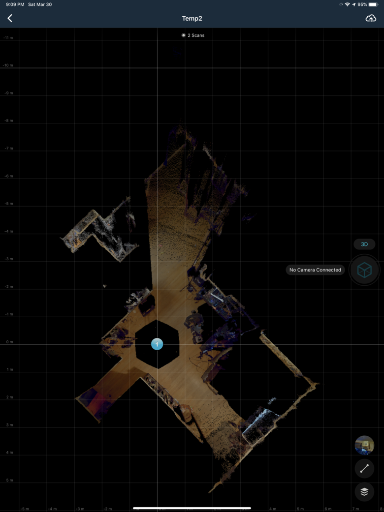 Matterport 360 Scan 3D converted, isolated from the original scan so you can see just the 360 conversion data: 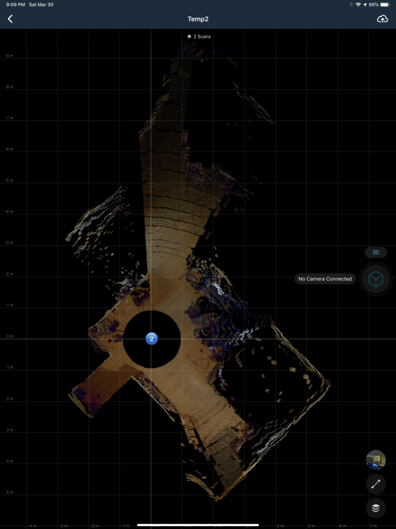 Insta360 One X 3D Scan: 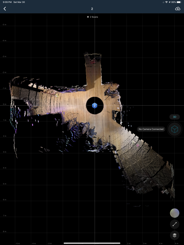 Matterport Native 3D Scan with it's own 360 conversion together: 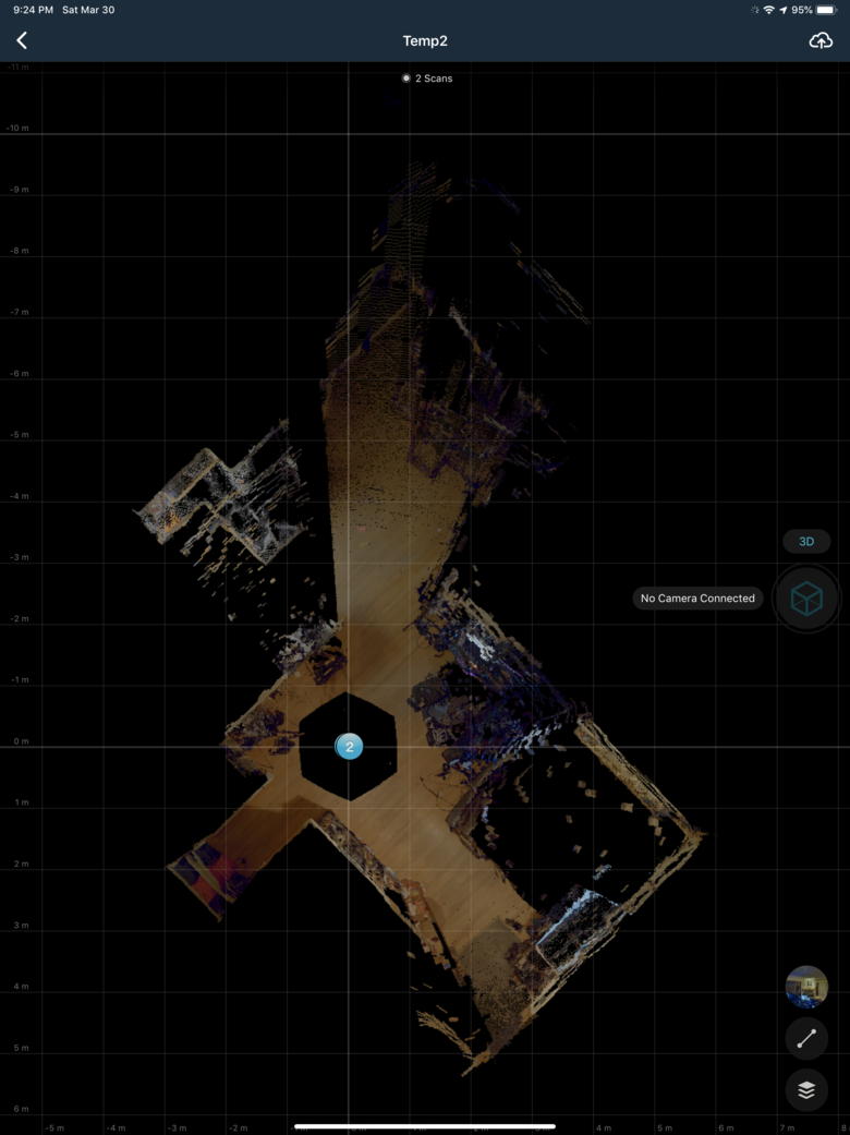 |
||
| Post 9 • IP flag post | ||
|
|
xiarosh private msg quote post Address this user | |
| Thanks for the great test. I think you a right . Now, In my regular version 3.0.1 - I can't place 360 on a plan. I just can open and only take a look on an 360 image. I can place it on a plan only in the Workshop after uploading. >> The 3d conversion capability is only available in beta Looks like I understand wrong some announce about Capture 3.0 and Matterport: Cloud 3.0, and description of Capture from Appstore about 360 conversions in regular version in ver.3.0 ( you can fount in Version History ) Some Big News from Matterport : https://matterport.com/blog/2019/01/28/some-big-news-matterport/ https://itunes.apple.com/ca/app/matterport-capture/id701086043#?platform=ipad 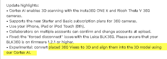 |
||
| Post 10 • IP flag post | ||
Pages:
1This topic is archived. Start new topic?