


Indoor Reality Launches IR-100 and IR-200: iPhone Based Reality Capture7769
Pages:
1|
|
indoorreality private msg quote post Address this user | |
| Berkeley, California, September 5, 2018 – Indoor Reality announced the latest update to its 3D mobile mapping solution – IR-200 and IR-100 – iPhone based reality capture systems which can be used for rapid, affordable floor plan generation of buildings and their assets. Existing systems are bulky, large, expensive and take a long time to capture by having to move a tripod around. IR-200 and IR-100 democratize reality capture by making it affordable for all building professionals ranging from real state agents, to contractors, to insurance agents. In addition, with IR-100 and IR-200, it is possible to tag assets real time during acquisition. IR-100 uses an iPhone only and IR-200 is a rig consisting of an iPhone and a 360 camera (see picture). To use IR-100, simply download the Indoor Reality app from Apple's App Store with standard monthly subscription of $14.99. For IR-200, upgrade to premium subscription in App Store with monthly rate of $24.99, and purchase the Panoramic Kit for $599 from Indoor Reality from within the App. To capture a space, simply invoke the app on your iPhone and follow instructions. After capture, Indoor Reality's cloud processing automatically creates 2D floor plans (DXF or SVG), web based interactive visualizations of the space, and a summary report indicating square footage and surface area on a room by room basis. IR-200 results in 3D immersive interactive visualization, while IR-100 creates 2D views (see attached pictures). Both viewers allow for measurements on the floor plans or in 2D/3D pictures, as well as tagging assets. Simply search for the app under "Indoor Reality" in Apple's App Store. Android version of the app will be released in Q4 2018. For more info, contact info@indoorreality.com or visit our web page 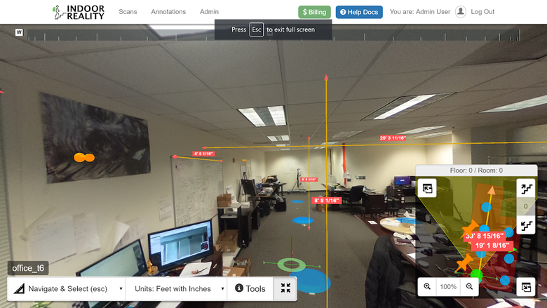 Above: Screenshot of IR-200 3D Immersive web based visualization 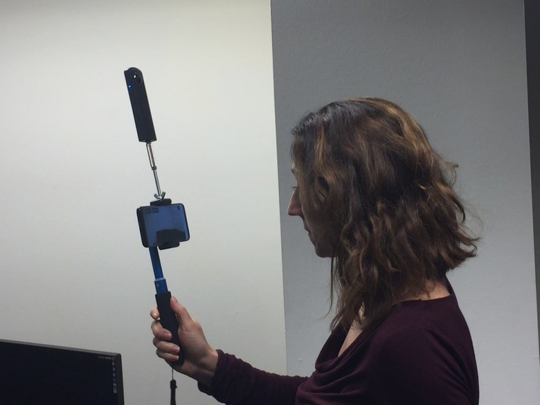 Above: Operator using IR-200 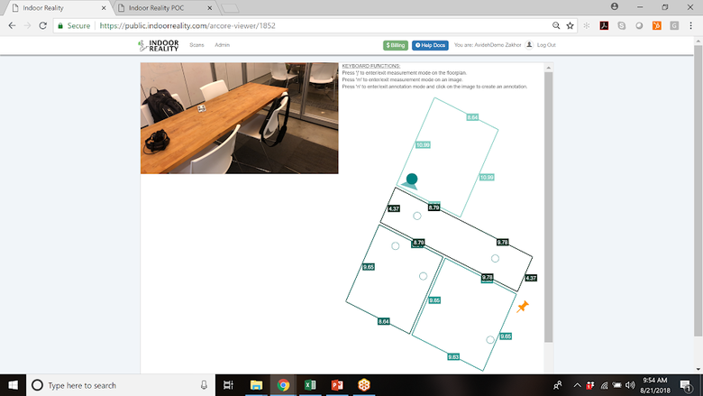 Above: Screenshot of IR-100 2D web based visualization |
||
| Post 1 • IP flag post | ||

|
CFster private msg quote post Address this user | |
| Very interesting. | ||
| Post 2 • IP flag post | ||
|
|
CFster private msg quote post Address this user | |
| Well I guess my iPhone 6 is too old for the app. | ||
| Post 3 • IP flag post | ||
|
|
indoorreality private msg quote post Address this user | |
| Hi, Here is the list of devices that our solution currently works on: iPhone 6s and 6s Plus iPhone 7 and 7 Plus iPhone SE iPhone 8 and 8 Plus iPhone X iPad Pro (the 10.5-inch model, 12.9-inch model and the older 9.7-inch model) iPad (2017) Indoor Reality Team |
||
| Post 4 • IP flag post | ||
|
|
CFster private msg quote post Address this user | |
| Well I have an iPad Pro... Are there any examples of floor plans with measurements I can look at? I do real estate photography. Thanks. |
||
| Post 5 • IP flag post | ||
 WGAN Basic WGAN BasicMember New Brighton, PA |
frstbubble private msg quote post Address this user | |
| @indoorreality What are the accuracy of the dimensions? | ||
| Post 6 • IP flag post | ||
|
|
indoorreality private msg quote post Address this user | |
| The accuracy depends on the size of the captured area, the path traversed, speed of walking, and the appearance of the area. That said, here are some rough guidelines: For IR-100 and IR-200, the accuracy for a residential home of up to 4000 sqft is about plus or minus a foot. The capture time is 20 mins. |
||
| Post 7 • IP flag post | ||
|
|
indoorreality private msg quote post Address this user | |
| A number of folks, have asked access to sample data. Here are the instructions: Use Chrome to go to: https://public.indoorreality.com user id: ir200demo@indoorreality.com pwd: ir200demo There are three data sets: "Grant St" and "August iPhone Theta" were done with IR-200 and "ir100demo" was done with IR-100 ( i.e. just subscribing to App store and nothing else). All data you see when you log in, was automatically generated with Indoor Reality cloud processing. The data products on the left column are downloadable, and the ones on the right are "interact-able". Note that the floor plan is auto generated in dxf and svg format and can be converted easily online to pdf if needed. In the 3D viewer, you can measure along various axis on the pictures OR on the floor plan. |
||
| Post 8 • IP flag post | ||
|
|
CFster private msg quote post Address this user | |
| In one of these threads, you posted a video depicting the process. One step after clicking on the corners of the room is to “raise the phone and take a picture”. Take a picture of what? From what angle? From what height? For what purpose? | ||
| Post 9 • IP flag post | ||
|
|
indoorreality private msg quote post Address this user | |
| The pictures are purely for informational purposes. We have multiple products: IR-100 and IR-200. IR-200 is a rig plus a 360 camera plus a phone. IR-100 is just a phone. For both you download an app from Apple App store. For IR-200 you will have to order the rig and pano kit for $599. For both apps, when you fire it up, it asks you to indicate your preference regarding the frequency at which pictures are taken. For IR-100 pictures are taken by the phone , for IR-200 pictures are taken with the 360 camera. Both cases, we put "dots" or something in the viewer so that you can click on it and see the picture captured at that moment. The picture is purely informational for user. You can set the period to be super large and you get fewer dots in the viewer. Pictures are not used to make floor plans. Either case, the system "beeps" you few seconds before a picture is taken, and also a beep right when it is being taken. This way the operator has the option of "freezing" so that the taken image is not blurry. Attached are the screenshot of viewer for IR-100 and IR-200. As you can see the viewer for IR-100 is 2D and for IR-200 is 3D. For IR-200 you can also look at some of the videos on our web page that shows the user interface for IR-200. The 3D viewer we use for IR-200 is the same one as IR-500 and IR-1000. In addition to periodic pictures mentioned above, the operator can purposefully point the phone at any object of interest and click the "tag assets" button on the phone, then in the web viewer there will be a "thumbthack on the web viewer" when we automatically generate it, and there will be a high resolution picture of that object, and optionally the operator can leave an audio message for that asset which can then be played back in the web viewer. See below: Above: 2D viewer example for IR-100 Above: 3D viewer example for IR-200 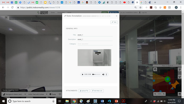 Above: Example of asset tagging during acquisition; You can tag asset during acquisition by pointing the device at it; in the web viewer this results in a pin at the location of the object and a high resolution image of the asset. Optionally you can record an audio clip during acquisition for that asset that you can play in the web viewer post acquisition. |
||
| Post 10 • IP flag post | ||
Pages:
1This topic is archived. Start new topic?