


Examples of small out buildings5174
Pages:
1

|
Wonderdawg private msg quote post Address this user | |
| Anyone done any small out buildings like utility barns or sheds they can share? Thanks in advance! Kerry |
||
| Post 1 • IP flag post | ||
 WGAN Forum WGAN ForumFounder and Advisor Atlanta, Georgia |
DanSmigrod private msg quote post Address this user | |
| @Wonderdawg We Get Around Atlanta Associate Photographer and Photographer Yair Yepez did a barn/apartment on many acres along with the house. Instead of scanning the half-mile to the barn/apt, we did a rich media MatterTage in each so that you can see the barn/apt without leaving the house. Here's how we delivered the Matterport Spaces 3D Tour using WP3D Models for the Single Property Website. The drone video was provided the agent: www.4400sandycreekroad.info Best, Dan |
||
| Post 2 • IP flag post | ||
|
|
Bale100 private msg quote post Address this user | |
| Old Ibiceno Farmhouse with several outer buildings now converted into holiday Villa Rental. Owner could not easily communicate layout to potential guests even with floor plans and Aerial images. Cropped pathways to limit data as model is >300 scans. Scans deliberately avoid reflections; glass, mirrors, metallics where possible. |
||
| Post 3 • IP flag post | ||
|
WGAN Forum Founder and Advisor Atlanta, Georgia |
DanSmigrod private msg quote post Address this user | |
| @Bale100 Beautiful. I want to stay there! @Wonderdawg These interactive image and area maps may be helpful from CartoBlue. Best, Dan |
||
| Post 4 • IP flag post | ||
|
|
Bale100 private msg quote post Address this user | |
| Thanks Dan. We have it pencilled in for the winter to add a carto map as I think this will help nail their problem, however property (red dot) is in restricted airspace (grid) 3 miles from airport (yellow dot) and 1 mile from flight path. Law states no flying drones in grid or within 5 miles of airport. Fines in Spain for breaching are €250k. Waiting for Nov. when tourist charter flights stop and will try to seek permission from aviation Authority & Air Traffic Control. 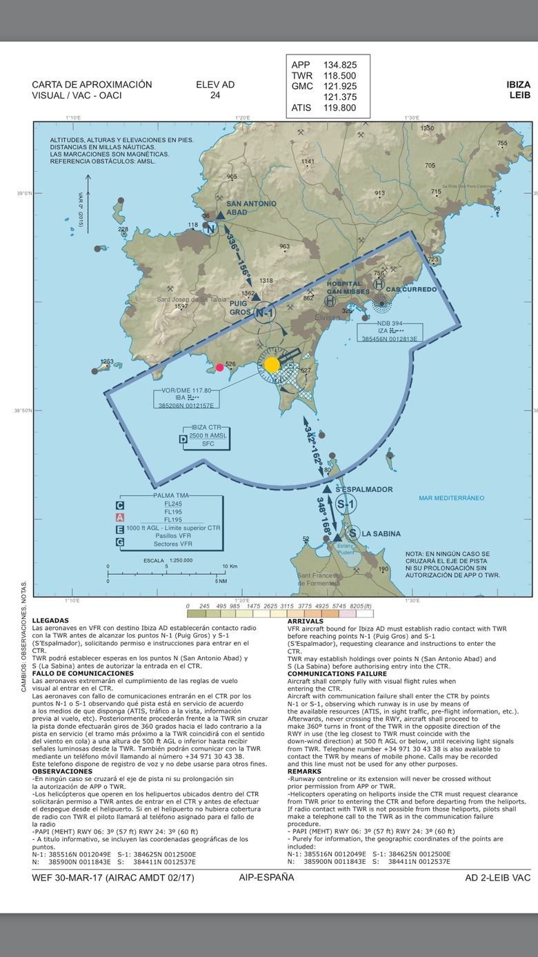 |
||
| Post 5 • IP flag post | ||
|
WGAN Forum Founder and Advisor Atlanta, Georgia |
DanSmigrod private msg quote post Address this user | |
| @Bale100 Could you do the "aerial" with one of these carbon fiber NodalN Ninja poles designed for this purpose? Dan P.S. Good to hear about your plans to go forward with @CartoBlue ... for those new to using interactive area or imagine maps ... 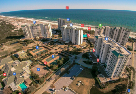 An example of a Real Estate Interactive IMAGE MAP powered by CartoBlue. A CartoBlue Image Map includes visual storytelling digital assets such as: Matterport, immoviewer and iGuide 3D Tours; video; aerial photography; 2D and 3d Floor plans; and photos. Are you working with multi-family communities, vacation rentals, hotels and resorts or schools (or want to)? One of the ways you can add value to the 3D Tour experience is to add an interactive area map with clickable links to the 3D Tours from CartoBlue. CartoBlue interactive area maps and interactive image maps are easy, fast and affordable. Plus, including interactive maps in your bundle pricing or offering as an optional extra is a great way to help differentiate your 3D Tour business. (A CartoBlue Image Map includes visual storytelling digital assets such as: Matterport, immoviewer and iGuide 3D Tours; video; aerial photography; 2D and 3d Floor plans; and photos.) Plus, CartoBlue interactive maps seamlessly integrate with Matterport, imoviewer and iGuide 3D tours (as well as your other digital assets). Plus, as of today (15 December 2016), here are Special Offers for We Get Around Network Benefits for Basic, Standard and Premium Members ✓ 20 percent off CartoBlue interactive area maps ✓ 20 percent off CartoBlue interactive image maps ✓ 10 percent off all other CartoBlue services ✓ all CartoBlue start-up fees waived Here is the CartoBlue Special Landing Page to Redeem Above Offers. For the Promo Code, please see the We Get Around Network Welcome Onboard Letter (Member password required). |
||
| Post 6 • IP flag post | ||
|
|
Bale100 private msg quote post Address this user | |
| Thanks for info. I think the ninja poles could serve a purpose in certain markets e.g. events etc. For the Puig Redo Villa, it is situated on 3 hectares and a rising slope of 25 degrees. Drone @ legal limit of 400 ft is the solution for carto map if we manage to obtain aviation approval. |
||
| Post 7 • IP flag post | ||
Pages:
1This topic is archived. Start new topic?