


Konami Code found in GeoCV Viewer4314

Frisco, Texas |
Metroplex360 private msg quote post Address this user | |
| http://models.geocv.com/view/nstpz Up, Up, Down, Down, Left, Right, Left, Right, B, A, H Unfortunately, there's not a lot going on here. |
||
| Post 1 • IP flag post | ||

|
CelisNet private msg quote post Address this user | |
| Wow those GeoCV models looks great. First time i see a real competitor to matterport. But in the GeoCV page they have a video that shows a girl scanning with a tablet, and in the model bathroom you can see a reflection of a camera. What camera is it? 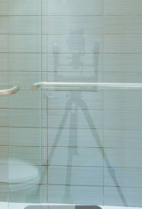 |
||
| Post 2 • IP flag post | ||
 WGAN WGAN3rd Party Service Member Beijing |
JuMP private msg quote post Address this user | |
@CelisNet It is one DLSR on Gigapan. Gigapan cost around USD1000.00 To my opinion: it is something like "break a butterfly upon the wheel". You can go https://www.360cities.net/. There are lots of splendid panos that enough for tours of house. Almost all of them taken by hand + DLSR (no Gigapan). Gigapan was used to generate Giga pixel Pano for very detail scene of a city but it take times. To use Gigapan here can only be thought as an experiment. For end customer the Gigapan is too expensive. The right equipment should be one motor like Matterport used or by hand like iGuide/RealVision. |
||
| Post 3 • IP flag post | ||
|
Frisco, Texas |
Metroplex360 private msg quote post Address this user | |
| I think that GeoCV have created some tech demos in order to raise investor capital... my concern is that they are creating a system that already exists - the main differences being cosmetic changes in the player and the prospect of using a Project Tango device for 3D Imaging and a yet to be specified camera system... As much as I don't -love- the Theta S - I still think that Theta S should be the target platform for a lot of things. If GeoCV combined Theta S with the Lenovo Tablet -- both using GPS for alignment, they could essentially build a system that produces Matterport-like results without getting stuck in a nasty legal battle over patents. Or - they could create a mounting stand for both the Theta and the Lenovo Phab. Lock in both devices and there you go. |
||
| Post 4 • IP flag post | ||
|
|
CelisNet private msg quote post Address this user | |
| @JuMP @Metroplex360 Thanks for the info. That makes a lot of sense. I was very intrigued because GeoCV advertise his product as something any agent could do with just a tablet. Do you think that would be an option in the near future? We pros should be prepare when that time comes. |
||
| Post 5 • IP flag post | ||
|
WGAN 3rd Party Service Member Beijing |
JuMP private msg quote post Address this user | |
| @CelisNet From the statement of GeoCV's person in another post. You need go two times for the capture: one for Panos and another for 3D. I think at the beginning of Matterport they can do the same thing. But after they combin two loops to one step with three PrimeSense's sensors they made Matterport Camera. The Matterport way is the best efficent way from it was born to now. But technology go fast, there would be better solution in the near future. But Matterport still has chance: the cost of his hardware is cheap. Hope the better solution came from Matterport's lab soon. |
||
| Post 6 • IP flag post | ||
|
WGAN 3rd Party Service Member Beijing |
JuMP private msg quote post Address this user | |
| @Metroplex360 I like Theta S. But there is one problem when you use it. Theta S take 360 pano at on shoot. Where can you hide yourself? I think the SP360 4K is a better choice.  |
||
| Post 7 • IP flag post | ||
 Blue-Sketch Blue-SketchFounder New Orleans, LA |
PetraSoderling private msg quote post Address this user | |
| I saw them on Rothenberg Venture stand in TechCrunch 2015, they were already funded back then. I spoke with the two Russian gentlemen twice during the show and liked their kind, down-to-earth attitude. | ||
| Post 8 • IP flag post | ||
 GeoCV GeoCVCo-Founder New York City |
AntonYakubenko private msg quote post Address this user | |
| Yeah, we do use a DSLR camera with fish-eye lens on an automatic panoramic head (GigaPan) for capturing panoramas. It's a temporal solution for us and we'll introduce a more elegant and efficient solution when we release our solution to beta service providers. We capture the 3D scan using a handheld mobile device with a 3D camera like Google Tango. That's how we started. Just 3D scans appeared not to be enough for real estate marketing purposes. So adding 360 panoramas currently captured with existing techniques is a logical transition step for us from we've started with to what we're going to become to deliver the best 3D virtual tours solution to the market. We're happy to share our current work-in-progress results to get the feedback from the community, which could help us shape the future of the most useful product. |
||
| Post 9 • IP flag post | ||
|
Frisco, Texas |
Metroplex360 private msg quote post Address this user | |
Quote:Originally Posted by JuMP Most people hide under it. You can of course walk around a corner. |
||
| Post 10 • IP flag post | ||
|
GeoCV Co-Founder New York City |
AntonYakubenko private msg quote post Address this user | |
Quote:Originally Posted by Metroplex360 Nice catch |
||
| Post 11 • IP flag post | ||
|
|
CelisNet private msg quote post Address this user | |
| @AntonYakubenko Thanks a lot for the info. Your models so far are looking great, love the floorplan view. I just don't see what would be the big difference from matterport? A white label version, downloadable 360 panos? Please do keep us posted on your progress. |
||
| Post 12 • IP flag post | ||
|
GeoCV Co-Founder New York City |
AntonYakubenko private msg quote post Address this user | |
| @JuMP We've tested many available 360 cameras and concluded that their image quality is not enough so far. The declared megapixels are not a true resolution. Cameras producing high-quality imagery are either very expensive or are a rig of DSLR/mirrorless cameras, again expensive and not convenient. We liked Samsung's camera the most, but it's still incomparable with DSLR quality. Below are some results from our internal tests, we do not pretend it's super accurate and comprehensive, but it shows the general picture. Hope you'll find it helpful. 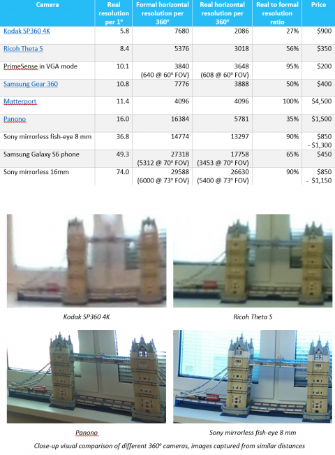 For sure, you do save some time on capturing by using a 360 camera instead of any rotating camera. We prefer to hide from the camera completely to eliminate photographer's reflections and shadows. In this case, the difference in shooting time between a 360 camera or a rotating camera becomes less, but is still tangible. We wish better 360 cameras appear in the market for an affordable price and we could leverage that. Our main technological value is in advanced software for 3D virtual tours stitching and advances in hardware produced by large manufacturers are good for us. |
||
| Post 13 • IP flag post | ||
|
GeoCV Co-Founder New York City |
AntonYakubenko private msg quote post Address this user | |
| @CelisNet Quote: Originally Posted by CelisNet Thanks! The difference from Matterport: 1. 5x cheaper hardware required. 2. Up to 15x higher resolution of imagery. Realizing these advantages is work-in-progress. And a lot of touches to give a different look and feel would be made during the road. We're also testing different business models. Do you see any non-technological ways for virtual tours solutions to differentiate from each other? For example, if a solution provider would also provide you customers on a revenue-sharing model? |
||
| Post 14 • IP flag post | ||
|
WGAN 3rd Party Service Member Beijing |
JuMP private msg quote post Address this user | |
| @AntonYakubenko Would you please show something that can be proof of your 15x higher resolution? For example take a showcase as below:  link So that it can be compared to Matterport's result at the same scene. And would you please provide some pictures or short video when you shoot this to show the working process of Pano step and 3D scan step. Thank you. |
||
| Post 15 • IP flag post | ||
|
GeoCV Co-Founder New York City |
AntonYakubenko private msg quote post Address this user | |
Quote:Originally Posted by JuMP You can check full-resolution panoramas here: https://www.dropbox.com/sh/vazqp8wkn5m2kce/AABv8HL5JSu64bkOCg5-QRBBa?dl=0 They are around 80 megapixels, while Matterport ones are 6 megapixels, as far as I know. We gonna release higher resolution panoramas support in our viewer soon (now we downsample them to the same 6 megapixels). Would be happy to share the update then. And our internal tests showed higher resolution makes a huge difference, especially if a 3D tour is viewed fullscreen. As for 3D scans are they better or not is more subjective, here are some our examples: https://skfb.ly/REy6, https://skfb.ly/PVK7, https://skfb.ly/KWIZ Quote: Originally Posted by JuMP Very nice outdoor scan! Quote: Originally Posted by JuMP We don't have our 3D tour for the same space that has a Matterport tour. We would make a side-by-side comparison when we're ready to release our DIY solution. Currently we're showing work-in-progress results to get feedback early on. Quote: Originally Posted by JuMP 3D scanning process is basically shown in the video on our website: It's walking around the space and waiving the 3D camera-enabled mobile device, i.e. "virtually painting" walls, floors, ceilings and furniture. A preliminary low-res 3D scan is shown in real-time. Then data is compressed, sent to the cloud and processed in higher resolution. Capturing panoramas is super straight forward when using a motorized panoramic head - it rotates a DSLR camera with a fish-eye lens at 6 angles and captures multiple exposure. |
||
| Post 16 • IP flag post | ||
|
Frisco, Texas |
Metroplex360 private msg quote post Address this user | |
Quote:Originally Posted by AntonYakubenko doh! I should have tried that |
||
| Post 17 • IP flag post | ||
|
Frisco, Texas |
Metroplex360 private msg quote post Address this user | |
Quote:Originally Posted by AntonYakubenko Matterport is 8192 x 4096. There are mobile, 1k and 2k tilesets. I'm not as skilled as the folks at dpreview in analysis, but I think that the quality of the image (sharpness, quality of image data) would certainly be useful. I also don't know how compressed Matterport's 8192x4096 images are. |
||
| Post 18 • IP flag post | ||
|
Frisco, Texas |
Metroplex360 private msg quote post Address this user | |
Quote:Originally Posted by AntonYakubenko Matterport = $3600, iPad (2017) = $329, Tripod = $150 Est Total: ~$4100 Lenovo Phab 2 Pro: $500 Ricoh Theta S: $300 Theta S Tripod: $50 GeoCV w/Theta= $850 or Panono Kit = ~$2400 GeoCV w/Panono = $2900 The question is -- what is the hardware actually going to be that takes the panoramas? Quote: Originally Posted by AntonYakubenko Matterport: 8,192 x 4096 Assumption above was that Matterport is: 4096 x 2048. 15x higher res = 61440 x 30,720. Perhaps we are talking pixels and want to subtract the nadir / zenith from Matterport as it does not shoot one? Or ... perhaps GeoCV is advocating use of a DSLR and not including the cost of a DSLR w/Fisheye as there is an assumption that one might already have this. |
||
| Post 19 • IP flag post | ||
|
GeoCV Co-Founder New York City |
AntonYakubenko private msg quote post Address this user | |
Quote:Originally Posted by Metroplex360 Oh, when we compared Matterport quality it was 6 cube maps of 1024x1024 resolution. Now I've found your thread about the changes to that: https://www.wegetaroundnetwork.com/topic/2535/matterport-making-huge-changes/ Anyway, it's not real 8192x4096 resolution as your images have shown. |
||
| Post 20 • IP flag post | ||
|
GeoCV Co-Founder New York City |
AntonYakubenko private msg quote post Address this user | |
Quote:Originally Posted by Metroplex360 Stay tuned for this Quote: Originally Posted by Metroplex360 I consider resolution to be the number of pixels, like when we say a camera has 12 megapixels resolution. When you multiply both width and height by 15 you get 225 higher resolution |
||
| Post 21 • IP flag post | ||
|
WGAN 3rd Party Service Member Beijing |
JuMP private msg quote post Address this user | |
@AntonYakubenko I have looked your detail pano. It is detailed 14340 * 7170 ~ 102.8megepixels. We can read the brand of the water tank. But it is unfair to compare 3 x PrimeSense's low cost camera module with one motor to DLSR with GigaPan when compete with resolution, and use the DIY cost to compete a Matterport's mass products when talk about the price. I believe the material cost of Matterport's camera is lower than USD1000.00, the selling price USD3600.00 is include the development cost and it's profit. You can't compare your raw materail hardware cost to Matterport's sale price. It is better to compare with the Matterport's raw material of hardware cost also. I have another question: How did you align the Pano to the 3D mesh? Matterport use PrimeSense and get the 3D and Pano at the same loop. But your solution seperate them to two loops. It is the key to make your Pano picture look like real 3D objects in showcase. How did you do that? Thank you. |
||
| Post 22 • IP flag post | ||
|
WGAN 3rd Party Service Member Beijing |
JuMP private msg quote post Address this user | |
| Here is a reference pano of Matterport. I quote one photo from Metroplex360 here.  Matterport showcase currently use 6pcs 2Kx2K cube maps and we can convert them to one 4Kx2K sphere map. It is 8megapixels. And GeoCV's resolution is 12x of that. |
||
| Post 23 • IP flag post | ||
|
GeoCV Co-Founder New York City |
AntonYakubenko private msg quote post Address this user | |
Quote:Originally Posted by JuMP Our solution to be released later down the road won't require a DSLR camera and a GigaPan motorized panoramic head. With a total investment cost from you as a service provider of around $1000 you'll be able to get ~100 megapixels panoramas as a part of a whole 3D virtual tours solution. Until we release our solution to the most interested beta testers you could just believe us, or not. We won't be making money on the hardware like Matterport does. We have a different business model. The hardware is basically produced by other guys like Lenovo, not us. And I honestly don't understand how the internal cost and not the price of the hardware could impact you as a customer who's paying the full price and not the cost. Can you buy Matterport camera for $1000? No. If Matterport starts selling their camera for another price we can reevaluate the comparison. Quote: Originally Posted by JuMP We've developed a computer vision algorithm that automatically aligns 360 panoramas to the 3D scan. 3D computer vision is the area of our expertise, we've been working in this industry for over a decade. |
||
| Post 24 • IP flag post | ||
|
GeoCV Co-Founder New York City |
AntonYakubenko private msg quote post Address this user | |
Quote:Originally Posted by JuMP 12x is still not bad |
||
| Post 25 • IP flag post | ||
|
Frisco, Texas |
Metroplex360 private msg quote post Address this user | |
Quote:Originally Posted by AntonYakubenko @AntonYakubenko - Oh my gosh -- I am so embarrassed now that I read that. [facepalm]. Of course, you are correct. Quote: Originally Posted by AntonYakubenko I do believe that it improves quite a bit -- and I am grateful that you referenced by previous post. There's a lot more clarity in the 2k tiles -- however, certainly on a more powerful camera, 2k tiles would have more data in them -- I'm certain of that. Quote: Originally Posted by AntonYakubenko Makes perfect sense -- thank you for clarifying. What it sounds like to me is that GeoCV is interested in providing a high level of zoom -- or when displayed on a faster computer with a fast Internet connection at a high resolution -- the panoramas will appear extremely high resolution. -- Quote: Originally Posted by AntonYakubenko Would you mind helping me out with this -- I understand what you are saying, but I lack the correct terminology. |
||
| Post 26 • IP flag post | ||
|
Frisco, Texas |
Metroplex360 private msg quote post Address this user | |
Quote:Originally Posted by AntonYakubenko One struggle that you will find throughout our forum is that we invested in Matterport cameras in order to provide a service that is of value to our clients. The high price of the Matterport Camera actually HELPS to prevent oversaturation in the market and many of us have not been too excited about the decrease in price as it is a double-edged knife. If GeoCV succeeds with a $1,000 solution -- it has the potential to hurt our industry. Quote: Originally Posted by AntonYakubenko That is -extremely- cool and I believe that it satisfies my inquiry that I made on the other thread concerning patents. |
||
| Post 27 • IP flag post | ||
|
WGAN 3rd Party Service Member Beijing |
JuMP private msg quote post Address this user | |
| @AntonYakubenko It is really cool that you can align Pano to 3D mesh even they were taken seperately. I don't know how to measure the real resolution of a photo. And I googled it with no result either. Would you please tell the way? I want to learn and would like try to measure them. Thank you! There is another reason why Matterport pano looks not so sharp. It is the size of the picture and compress rate limited by the network bandwidth and loading time. The pano I pasted is only 1MB. The compress rate is 4.17%. And compress rate of your DEMO pano is 9.55%. |
||
| Post 28 • IP flag post | ||
|
GeoCV Co-Founder New York City |
AntonYakubenko private msg quote post Address this user | |
Quote:Originally Posted by Metroplex360 Well, imagine you have a super crisp and detailed 1 megapixel image (1000x1000). Let's resize it 10x on each side to 100 megapixels image (10000x10000). The formal resolution of the image we've got is 100 megapixels, but the real one is 1 megapixel. There are different ways how you can measure the real resolution. When you read some consumer cameras reviews you can see the testing guys shooting and analyzing special linear patterns. You won't see thin lines on small resolution images, they would just become a gray mess. There are more scientific and accurate ways as well. And here is one approximate approach to measuring the real resolution when you don't have a special pattern in the image. Imagine you have 1000x1000 pixels image. Let's resize it to 800x800 and then resize the resulting image back to 1000x1000. Compare the processed image with the original one. Do you see a loss of details? Try to look at the real details, not the noise. No difference? Let's go further. Resize 1000x1000 to 600x600 and then back to 1000x1000, compare with the original one. If you see that there is a visible loss of real details it means that the real resolution of our 1000x1000 image is somewhere between 600x600 and 800x800. If you make more steps in such a process, for example, adding 700x700 step, you make a more accurate estimate. Please mind that this is a very approximate way and whether there is a substantial loss of details or not is subjective. But if could give a decent approximation for any image without any special patterns required. I'd also notice that "real resolution" could depend on the JPEG quality, camera parameters during shooting, the lighting in the scene, etc. So to compare apples to apples you need more "laboratory" testing setup. But this simple approach described above could give a good estimate of the real resolution for any image. |
||
| Post 29 • IP flag post | ||
|
GeoCV Co-Founder New York City |
AntonYakubenko private msg quote post Address this user | |
Quote:Originally Posted by Metroplex360 I totally understand. Consider our solution as an opportunity, not a threat. An opportunity to do more business and scale it further. Matterport says 2.5% homes for sale in the US have its 3D tour. I hope together we can successfully go after other 97.5%. I don't think your main competitors are other photographers who bought a more affordable 3D tours solution. And in most cases neither are realtors who often don't want to shoot by themselves. By providing a more affordable service using our solution and reaching a larger audience you can do grow your business. Imagine the world when at least 20% of realtors doing 80% transactions have a habit of ordering a 3D virtual tour, professional photos and a floor plan. 80%, not 2.5%. Would you have a better business then? Maybe more people in the team, and more cameras, which don't cost you a fortune. The elasticity of the market is subject to testing, but if we look on the industry from the outside - everyone (home buyers, home sellers, agents, brokerages, photographers, listing portals) would benefit if more and more listings would have a high-quality 3D tour and professional photos. We're here to make this future come true together. Too pathetic, I know, but that's the truth. |
||
| Post 30 • IP flag post | ||
This topic is archived. Start new topic?