


GeoCV is real competitor Masterport!4313

|
Max_Sodomovskiy private msg quote post Address this user | |
| Try this: http://models.geocv.com/view/pjk145 | ||
| Post 1 • IP flag post | ||

Gibbsboro, NJ |
Radie842 private msg quote post Address this user | |
I'm not so sure about that |
||
| Post 2 • IP flag post | ||

|
grmngrl private msg quote post Address this user | |
 Same here, so not quite a competition yet I guess.  |
||
| Post 3 • IP flag post | ||
 Blue-Sketch Blue-SketchFounder New Orleans, LA |
PetraSoderling private msg quote post Address this user | |
| I like the fact the circles appear only as you approach them (or hover a mouse in the proximity). That will work nicely if you want to take a screenshot of an empty room and have the still image virtually staged. Nice seamless flow when you move around. |
||
| Post 4 • IP flag post | ||

|
davidpylyp private msg quote post Address this user | |
| Its ok Copies are always cheaper than the original |
||
| Post 5 • IP flag post | ||
|
|
grmngrl private msg quote post Address this user | |
| I like the video presentation. Looks cool. | ||
| Post 6 • IP flag post | ||
|
|
qpoisson private msg quote post Address this user | |
| @Max_Sodomovskiy looks similar to matterport. what camera do they use ? | ||
| Post 7 • IP flag post | ||

Regina, Saskatchewan Canada |
Queen_City_3D private msg quote post Address this user | |
| I like it. That said, it looks like a jailbroken Matterport scan where the background has been changed and a 2D floorplan superimposed over the photorealistic floorplan (which is a great idea!). Is this a separate camera, or the Matterport? If Matterport, isn't this a prohibition of the terms of use? |
||
| Post 8 • IP flag post | ||

|
Property3dNZ private msg quote post Address this user | |
| @Queen_City_3D I'm fascinated to know how its been created too! | ||
| Post 9 • IP flag post | ||
|
|
Max_Sodomovskiy private msg quote post Address this user | |
| http://www.geocv.com/ | ||
| Post 10 • IP flag post | ||
 GeoCV GeoCVCo-Founder New York City |
AntonYakubenko private msg quote post Address this user | |
| Hi everyone, Let me introduce myself. I'm Anton, GeoCV co-founder & CEO. We're developing an affordable solution for high-quality true 3D virtual tours. In contrast to Matterport, we're using off-the-shelf new-generation phones with 3D cameras like Lenovo Google Tango for capturing. They cost around $500 and the total cost of required hardware would be in the ballpark of $1000. And we're on a track to produce higher resolution 3D scans (textures - https://skfb.ly/REy6, geometry - https://skfb.ly/KWIZ) and 360 panoramas (80-100 megapixels). We understand how important the quality of imagery in real estate is, so you would be even able to extract print-ready HDR photos from our panoramas. And of course, get a floor plan from the 3D scan. All the content you see was captured and processed using our proprietary software and visualized in our own 3D viewer. The viewer is work-in-progress, so please excuse us for some glitches. Mobile devices support to be released in the coming weeks. Support for full resolution panoramas is coming soon (now we downsample them 15x). And even more convenient navigation is on the way. We're currently polishing our solution by providing a service in New York, where we're based of. For $149 we provide a whole package of visuals for real estate marketing: still photos + floor plan, which are a must, and a 3D tour to differentiate your listing and yourself. If you're in New York or know realtors and photographers there, just drop me a line at [Private Message me] to try our service. We're planning to release our DIY solution to professional service providers and real estate agents and brokerages later this year. So I would love to head your wishes - how could we make the most useful solution for you? Matterport are great guys, the market disruptors and educators. They've conquered a decent share of luxury segment and now scale to non-real estate verticals. We're a rival introducing a more affordable solution delivering higher visual quality. I honestly hope it would help us bring 3D tours, high-quality photos and floor plans to each of your listings. From day one we took another approach than Matterport leveraging just appearing consumer devices with 3D cameras rather than a proprietary expensive scanner, which requires different advanced computer vision software. And that's the area of our expertise - we've been working in 3D computer vision industry for over 12 years, and GeoCV was founded 3 years ago. |
||
| Post 11 • IP flag post | ||
|
|
qpoisson private msg quote post Address this user | |
| @AntonYakubenko thanks for the introduction. It's definitely interesting to see another more affordable solution in the market. May I ask some questions about your new system? Do you also use the tango phone to capture panorama images? Or can we use our own traditional camera to get high-quality panos ? Second, is it easy to use a phone to capture the scene? Is it robust ? I tried matterport's Scene app before. Sometimes when I lost tracking, I have to re-do for the whole scene. That's annoying. How much time will it take for a typical flat or house? Finally, when will your app available to us ? Thanks |
||
| Post 12 • IP flag post | ||
|
GeoCV Co-Founder New York City |
AntonYakubenko private msg quote post Address this user | |
| @qpoisson, sure would be happy to answer. Quote: Originally Posted by qpoisson We're currently using a regular DSLR camera with a fish-eye lens for capturing panoramas, and we're considering different options. And what way would you prefer and why? Quote: Originally Posted by qpoisson Right now there are some tips & tricks for capturing, that's why we're polishing the tech in-house for now. But it should be very robust and easy-to-use as soon as we release our DIY solution. Are you satisfied with the scanning experience of Matterport? Quote: Originally Posted by qpoisson 3D scanning is pretty fast - around 15-20 minutes per 1000 sqft, depends on the layout and furniture. Taking panoramas takes 2x of this time. We see ways to speed it up. How do you think, what should be a reasonable time? It could help us set a benchmark. Quote: Originally Posted by qpoisson It would be available later this year, no exact dates yet. It's very important for us to gather a "wish list" to take it into account in our product roadmap. |
||
| Post 13 • IP flag post | ||

|
nat_vanveen private msg quote post Address this user | |
| @AntonYakubenko Hi Anton, thanks for introducing your product to us. I would be very interested in following your progression and one day making use of it. Cheers, Natalia |
||
| Post 14 • IP flag post | ||
|
GeoCV Co-Founder New York City |
AntonYakubenko private msg quote post Address this user | |
Quote:Originally Posted by PetraSoderling Thanks! We'll also allow extraction of stills from panoramas, so you won't even need to do a screenshot with some controls overlay. |
||
| Post 15 • IP flag post | ||

Frisco, Texas |
Metroplex360 private msg quote post Address this user | |
| So.... the example tour is a composite of a 3D capture + panoramas from a DSLR. That's not so different from the experience that was custom created to promote 50 Shades Darker -- http://christiangreysapartment.com Personally, I think that GeoCV will be disruptive in any area where they offer customized solutions that fit niche needs. BTW - here's another example: http://models.geocv.com/view/nstpz |
||
| Post 16 • IP flag post | ||
|
GeoCV Co-Founder New York City |
AntonYakubenko private msg quote post Address this user | |
Quote:Originally Posted by Metroplex360 Wow, this is a cool one. We produce somewhat similar 3D tours, but in a more scalable manner, no customization is necessary. And we add a 3D layout view and a floor plan with dimensions into a single experience. We're exploring other more efficient ways of capturing high-res HDR panoramas. What would be the perfect solution, in your opinion? I believe, that two our main technological differentiators are a lower cost of required hardware and a better visual quality of the results (the potential is not yet fully realized). What customization could be useful for you? I ask so many questions because the community feedback would help us shape the future of the product. |
||
| Post 17 • IP flag post | ||
|
|
Property3dNZ private msg quote post Address this user | |
| @Metroplex360 thanks for that link - can see the rig in the shower reflection and it looks quite intense! | ||
| Post 18 • IP flag post | ||

|
JonJ private msg quote post Address this user | |
| @AntonYakubenko, Can you explain the workflow of your DIY solution? If you are able, please include specifics about capture time for the 3d model, number of panorams requierd to capture, equipment limitations (exteior scanning, bright sunlight?), post processing time and workflow for a 1000 sqft property. Are there limitations to the size of the space to be captured? Can 3d models be combined into a single model (2 operators scanning a single property at the same time)? Thank you for you response in advance! Jon J |
||
| Post 19 • IP flag post | ||

|
VisualKusuma private msg quote post Address this user | |
| My only wishlists on this would be.....white label & no subscription plan | ||
| Post 20 • IP flag post | ||
|
GeoCV Co-Founder New York City |
AntonYakubenko private msg quote post Address this user | |
Quote:Originally Posted by JonJ Sure, Jon. The capturing process is subject to changes and improvements. Currently it takes around 45 minutes per 1000 sqft with a goal to reduce it to <30 minutes (we know how to do it). Now it's a 2-step process with 3D scanning and capturing panoramas done separately. 3D scanning takes 15 minutes, panoramas - 30 minutes. Capturing time depends on whether the space is empty or furnished, and the preferred density of panoramas - you can be flexible about the number of panoramas, typically ~15 for each 1000 sqft to provide a smooth walkthrough experience without jumps from room to room with a loss of context. If you have a reasonable desirable benchmark for capturing time, I would love to hear it. We use panoramas for extraction of photos as well. For some photos it makes sense to use particular viewpoints. e.g. from the corner of the room, which are not useful for a virtual tour. So a few additional panoramas could be required in this case. Having panorama for photos extraction could give you flexibility in post-processing the photos. We use active 3D (depth) cameras, which are similar in principles of functioning to PrimeSense 3D cameras used inside Matterport scanner. So they share the same limitations - direct bright sunlight, outdoor, limited range (15-20 ft). Old-fashioned 360-only virtual tours just manually link panoramas. What do you think of such an approach for outdoor panoramas? After you finished scanning, the data is sent to our cloud. Currently you don't need to do anything after that. Everything else is done using our automatic algorithms and manual quality assurance. We might move some manual actions from our backend to the photographer's control, for example, outlining mirrors. But nothing complex anyway. We didn't optimize post-processing time and quality assurance processes yet, so now it's closer to two days. We also optionally deliver a floor plan with room labels and dimensions extracted from the 3D scan. The goal is, of course, to return the results ASAP As we're working in New York for now, most apartments are not that large here We don't support simultaneous capturing by multiple photographers. Could you please describe the use-case? Thanks. |
||
| Post 21 • IP flag post | ||
|
Frisco, Texas |
Metroplex360 private msg quote post Address this user | |
| @AntonYakubenko There are definitely a lot of similarities between your solution and Matterport's. Certainly, it is necessary for your solution to distinguish itself in both a visual and technological manner. Consider that Matterport has patents concerning this technology including the manner by which the model is build from sequential scans. I noticed in your video that the method of scanning was a continuous scan rather than multiple individual scans -- is this a key to how you could offer a competing solution with a different implementation? Concerning navigation - Matterport seem to have a patent here too. And this is troubling. How does GeoCV proceed when Matterport seems to have patented the method by which a user moves through a 3D Object between panoramas? |
||
| Post 22 • IP flag post | ||
 WGAN WGAN3rd Party Service Member Beijing |
JuMP private msg quote post Address this user | |
| @AntonYakubenko How did you get 3D mesh of the house? Is it by photogrammetry from the photos? We are working long time in photogrammetry area. And we found photogrammetry is good solution for some object. But it is can't handle all materials within a house. The Matterport way (with PrimeSense's sensor) is the best way with best cost performance. The mesh result from your demo is very abnormal compare to Matterport. I guess it was caused by UV issue of your textures. You sould seperate the object mesh at the seams on UV.  And the accomplishment rate of your DEMO looks like our POC. You can visit our POC for richtag DEMO of Matterport here: clickable text I like Matterport. And I want to give Matterport an advice: Add another purchase option: 1. Lower the hardware price from USD3600.00 to 120% of the cost of it: For example: if the materail cost is USD1000.00 then sell at USD1200.00 2. Higher the data process fee from USD19.00 to USD49.00 for the first 100 showcase. 3. After the user shoot 100 showcase that means USD4900.00 total, the data process fee will lower to USD19.00 again. The KEY for Matterport's business is to make more his cameras in market and get more data process and more users/clients. Not to get the revenue of selling camera. The higher hardware price give more area for his competitors. But actually the hardware cost of Matterport won't more than USD1000.00 by my estimate. As a network/cloud services business company Matterport should expand his cloud computing business which will get more revenue because the cost of machine processing is linear and its revenue is exponential. |
||
| Post 23 • IP flag post | ||
|
GeoCV Co-Founder New York City |
AntonYakubenko private msg quote post Address this user | |
Quote:Originally Posted by Metroplex360 Matterport is definitely a disruptor in 3D virtual tours for real estate. But from the technological standpoint, their product is similar to previously existing ones. Capturing process and the ways 360-degrees scans are stitched together is similar to how all laser scanners (LiDAR) work, and they have been in the industrial market for decades. Matterport just used a different kind of 3D sensors, which allowed them to make a 3D scanner for $4,500, while the most inexpensive laser scanner Faro Focus 3D was $40,000 at that time. But now there are new LiDAR scanners delivering better visual quality and accuracy for $13,000 - $16,000 by Leica+Autodesk and NCTech. And capturing process (moving a scanner from spot to spot) and stitching algorithms (using 3D point cloud and 360 panoramas for alignment) are similar. Matterport visualization was unique for 3D virtual tours in real estate. But a very similar experience has been provided before that by Google Maps (not Google Business View), for instance. There is a true volumetric 3D model of the city, which you can rotate and pan freely. And then you can zoom in or jump into street view panoramas. The transition between panoramas are also smooth because Google also uses the underlying 3D mesh. You can even see the same 3D cursor changing its orientation depending on the normal to surfaces. If you go further you can actually notice similarities in the layout and design of controls as well. 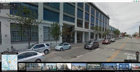 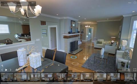 Is Matterport a copy of Google Streetview? Yes and no. It has just appeared to be the most useful interface. If you remember Matterport story they have started with offering realtors just a 3D scan with free-viewpoint navigation. But the feedback from the market was that the quality is not enough. So they came up with the solution you see today by incorporating 360 panoramas into a 3D scan. Our story was both similar and different. We saw an opportunity of upcoming mobile devices with 3D cameras. And we've developed a software solution for handheld 3D scanning of interior spaces. It required completely different approaches than stationary scanning, as we needed to reconstruct complex trajectories of a handheld device with a small FOV (field of view). But the scanning was fast, geometry was very detailed, and textures were high res as they were captured closer to objects. Yet we've got a consistent feedback that though the quality of our 3D scans was the best in the market in comparison to other solutions using depth cameras, it was still not enough for real estate marketing purposes. There are some fundamental problems of any 3D scanning technology, for example, transparent objects, thin objects, etc. And we understood that the quality bar for real estate visualization of real spaces (not talking about 3D models of not yet constructed properties) is close to 100% photorealism, not yet achievable for a random interior space with any tech. So we decided to add 360 panoramas to the complete experience. We tried many different ways of joining a 3D scan and 360 panoramas, for example, an option to walk through the 3D scan freely and smoothly go to the nearest panorama when you stopped. The goal was not to be just different from Matterport, but to provide the best experience to users. Our UX tests have shown that Google Streetview or Matterport experience is currently the most convenient one. Why GeoCV, Google Streetview and Matterport 3D viewers look similar? Because they are using the same type of data and all have independently found that it's the best way to visualize it. But we see some opportunities to improve the navigation and viewing experience and to add a unique look and feel to our product. So stay tuned for the upcoming updates. If you take a look at more old-fashioned 360-only virtual tours without true 3D content behind them, you'll notice that they are very similar to each other as well. There are 360 panoramas, a floor plan, highlights, and the difference is only in the ways the controls are designed, the size of the floor plan, etc. But in general, they're all very similar.   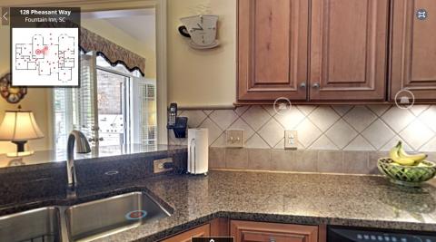 If we take a look at even less advanced solutions which allow you to manually link multiple 360 panoramas into a virtual tour, the only difference between them in terms of visualization is how the spots for jumping from one panorama to another look like (I like the pre-visualization of panoramas in small circles done by ImmoViewer and RoundMe). The big difference of our solution (or Matterport) is that we provide a real 3D scan, which brings several values: * Interactive 3D overhead view to present the layout * Smooth transitions between panoramas with proper occlusions (you can't jump to a panorama through a wall or a couch) * Extraction of pretty accurate floor plan without relying on a single reference measurement and photogrammetry But in contrast to Matterport we use 5x-10x cheaper hardware delivering up to 15x higher resolution of imagery. Each company in the space has its own story and proprietary software. I talked to the founders of all major competitors in person and tried their solutions hands-on. We started in 2014 and spent quite some time on developing our unique capturing and processing software. If we look at capturing process or the end results GeoCV and Matterport, they are similar because we use the same type of content. We both are different from others, which don't have a true volumetric model, but they are similar to each other. Both for capturing, processing and visualization the devil is in the details. |
||
| Post 24 • IP flag post | ||
|
Regina, Saskatchewan Canada |
Queen_City_3D private msg quote post Address this user | |
| @AntonYakubenko I do like how I don't see any stitching errors with your product. That's a huge plus. I do find that Matterport does a pretty good job with varied light settings through their internal High Dynamic Range photography, which essentially means you can go through the whole property without changing any camera settings. If you are using a DSLR, how much manipulation is required for ISO, shutter speed and aperature for each scan point? |
||
| Post 25 • IP flag post | ||
|
GeoCV Co-Founder New York City |
AntonYakubenko private msg quote post Address this user | |
Quote:Originally Posted by JuMP We're using active depth cameras like PrimeSense for capturing, in particular, PrimeSense itself, Occipital Structure sensor (based on PrimeSense Capri), built-in 3D cameras in Lenovo Phab 2 Pro and Google Tango mobile devices, and tried others as well like Intel RealSense. I totally agree that using such kind of sensors is the best way to go for scanning interior spaces. And you're absolutely right about photogrammetry. It works great for textured objects, but completely fails in real interior spaces with flat white walls, for example. Below are a couple illustrations. A great 3D reconstruction of a very textured scene (courtesy of realities.io, processed by Capturing Reality software): 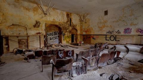 A failed 3D reconstruction of a more usual room (processed by Autodesk 123d software). 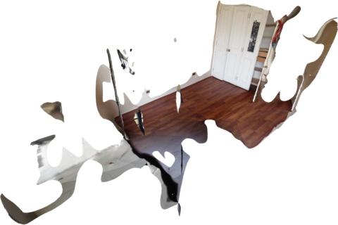 There are options to solve this problem by incorporating more high-level knowledge into 3D reconstruction algorithm, for example, recognizing edges, fitting in walls, as well as adding some manual input. In my understanding, that's what InsideMaps and Real.Vision are working on. But from what I saw so far such an approach doesn't produce really high-quality and complete 3D models in a robust way. Another way is to fuse robust 3D measurements from a depth sensor with higher resolution photos, which also work outdoors, to get the best of the both worlds. Quote: Originally Posted by JuMP Thanks for the feedback. We'll check the mesh, but it seems you've used a hack to show a wireframe model in our WebGL viewer and it's not shown correctly because vertices are connected in wrong order. You can see the real mesh here: https://skfb.ly/6nAYA And here is the screenshot: 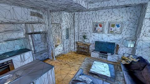 Quote: Originally Posted by JuMP What do you mean? Quote: Originally Posted by JuMP It's not my business to count other companies money, but Matterport has sold over 5000 cameras for $4,500 each, which gives them $22.5m in revenue for hardware, and 400,000 scans approximately for $19 each, which results in $7.6m for software subscription. But our thoughts were similar to yours and we're taking a different business model approach. |
||
| Post 26 • IP flag post | ||
|
GeoCV Co-Founder New York City |
AntonYakubenko private msg quote post Address this user | |
Quote:Originally Posted by Queen_City_3D Thanks! Quote: Originally Posted by Queen_City_3D We do have HDR processing so no parameters should be changed during shooting no matter how lighting conditions change. |
||
| Post 27 • IP flag post | ||
|
GeoCV Co-Founder New York City |
AntonYakubenko private msg quote post Address this user | |
| @VisualKusuma, thanks for the feedback. Quote: Originally Posted by VisualKusuma Matterport allows some branding. Is it not enough? Do you want to remove the technology provider branding at all? Doesn't it add some value as soon as the technology provider brand becomes strong? What about our modest light text "Powered by GeoCV"? Quote: Originally Posted by VisualKusuma What would be the more suitable pricing option? |
||
| Post 28 • IP flag post | ||
|
Frisco, Texas |
Metroplex360 private msg quote post Address this user | |
Quote:Originally Posted by AntonYakubenko I did not realize that Google was integrating the 3D Mesh. As both an MSP and a GTP -- I have found that Google's transitions and navigation is horrible and am surprised that the 3D Mesh is in use ... the transition between scenes certainly does not feel as smooth or look as nice as Matterport and that might be due to the mesh being less detailed as we are, of course, looking at a massive model with less detail at street level than Matterport at camera level. Thanks for pointing this out! Quote: Originally Posted by AntonYakubenko Agreed. There's only so many ways to skin a cat. I think that the feature set certainly determines the UX. One decision that I'm pleased you have made with GeoCV is to have the Floorplan and Dollhouse views as separate buttons. Matterport's combination of these two items into one button was a decision that I vocalized my dislike for. People end up NOT finding the floorplan if that's the case -- they are too busy with the dollhouse, then usually click into it and begin navigating again. I think that bringing new features to the market first and integrating them into the UI would certainly allow you to differentiate a bit. Quote: Originally Posted by AntonYakubenko Great! Quote: Originally Posted by AntonYakubenko Those are extremely slick touches -- I think they make a big difference. Quote: Originally Posted by AntonYakubenko That will be your defining quality. If that quote can stand up and is the experience that your users have, then you have an excellent produce and this will be successful. My only concern, which I expressed to you, was patents that Matterport owns and whether or not your solution would require a licensing fee from Matterport in order to exist or offer certain features. |
||
| Post 29 • IP flag post | ||
|
Frisco, Texas |
Metroplex360 private msg quote post Address this user | |
Quote:Originally Posted by AntonYakubenko I'm on the side of keeping the branding -- as long as it is not intrusive and distracting. I'm also a fan of the subscription plan as companies need to make $, pay their employees, build infrastructure and continue to innovate. From the consumer side, maintaining a strong cloud-based platform for fast delivery of content is necessary and allowing tours to be served locally only creates problems, fragmentation with results, and spurs a new 3rd party hosting market. Matterport are charging $50-$150 a month which is not bad considering that the price is $0 for hosting if you are scanning 3, 7 or 11 tours per month. No one should really be complaining about hosting except when and if they decide to stop scanning -- at that point, there's a bit of a problem. |
||
| Post 30 • IP flag post | ||
This topic is archived. Start new topic?