


Ski resort3779
Pages:
1

Hartland, Wisconsin |
htimsabbub23 private msg quote post Address this user | |
| Does anyone have a model of a ski resort I could use as a presentation piece? | ||
| Post 1 • IP flag post | ||

|
jfantin private msg quote post Address this user | |
| @htimsabbub23 do you mean a virtual tour of ski slopes or a Matterport model of ski rental shops, etc? | ||
| Post 2 • IP flag post | ||
|
Hartland, Wisconsin |
htimsabbub23 private msg quote post Address this user | |
| I was thinking more along the lines of a lodge and rental area but I'm open to ideas. | ||
| Post 3 • IP flag post | ||
|
|
jfantin private msg quote post Address this user | |
| Well, if it is just a lodge or rental area, it will be not different than any other Matterport project, like a hotel lobby or any shop. I do not have examples of that kind of places with Matterport, but I do have samples of ski slopes that I made with a special camera (6 lenses, 7 panos per second, GPS or remote control activated, etc). I mapped a complete mountain (the biggest ski resort in South America with hundreds of kilometers of skiable tracks) in three days driving a snow mobile with my camera mounted in a backpack. 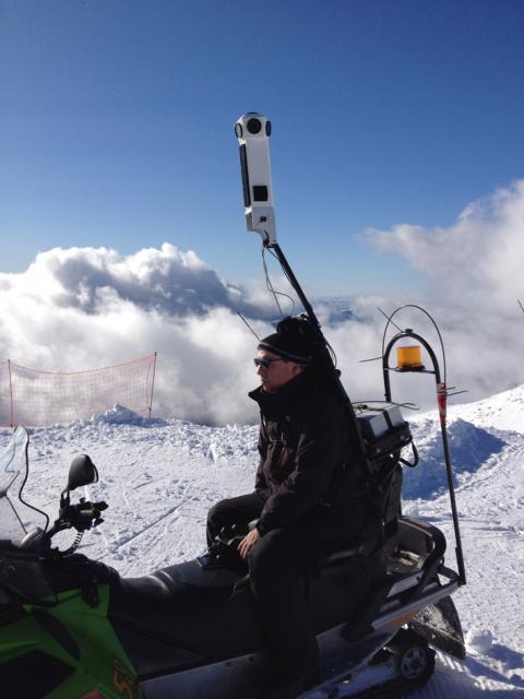 If you are interested, just send me a PM and I will explain and we can talk and exchange ideas. |
||
| Post 4 • IP flag post | ||
|
Hartland, Wisconsin |
htimsabbub23 private msg quote post Address this user | |
| WOW! That's pretty ineradicable. I would love to chat more. I am doing this for what may be the smallest ski hill in USA. 200 ft vertical drop. But that being said it is where I learned to ride and love the winter snow. I will PM you so we can chat more. I appreciate the help. | ||
| Post 5 • IP flag post | ||
 Standard StandardMember Wandsworth U.K. |
RobinLycka private msg quote post Address this user | |
| @jfantin Do you have a link that you can post to show the end results? looks very cool, is it just photospheres or photogrammetry as well ? | ||
| Post 6 • IP flag post | ||
|
|
jfantin private msg quote post Address this user | |
| I am sorry for the delay. I missed your question @3DscannUK This is a link to a small ski slope (just a few hundred meters). I took one pano each 10 meters while driving with a snow mobile at reasonable speed (it was green slope for begginers and children). I would say that it took me a couple of minutes at most. http://www.phisigmainteractive.com/LaHoyita-Catedral/index.html In the lower left corner you have access to a map and the possition of each pano (by clicking on the spots you move to that pano). The camera has 6 lenses and the images have all the info needed (lat, long, altitude, speed and direction, etc) The entire ski complex was done in three days working 4 to 5 hours per day |
||
| Post 7 • IP flag post | ||
Pages:
1This topic is archived. Start new topic?