


I did some crappy Ricoh Theta S Google Tours2446

Frisco, Texas |
Metroplex360 private msg quote post Address this user | |
| Hi Guys! I just had the opportunity to shoot some tours with my Ricoh Theta S. I was -thrilled- to use the Street View App to quickly snap several scenes after I completed my Matterport Tour. So Here's my Matterport Tour: https://my.matterport.com/show/?m=Zxmur1Vaczn And here's my Ricoh Theta S Tour: https://goo.gl/4d6lBu -- So ... the panoramas look blurry. They aren't sharp. The megapixel count doesn't seem to be pixel count... And ... for some reason I thought the tour would automatically stitch using GPS, etc. But it didn't... The Street View App was ridiculously easy to use... the Ricoh Theta S snaps images quickly ... and then you can upload images quickly ... and add links between images with a really easy little interface wherein you see both the current panorama and then the one you select to link it to ... and you can line the two up and click OK. My problem is that the resulting tour is very disorienting ... and perhaps I spaced the tours out too much... I don't know ... I lined things up perfectly and the result is haphazard madness. It's just junk really. I wanted to share my feeling with the community b/c honestly ... I thought the Ricoh Theta S experience was pretty cool ... but the result was kinda crap. The image quality (and yes, it's at 14MP) looks terrible... and the Matterport Tour exceeded it in every way. Anyone else have a Theta S and feel that the megapixel count is inflated as to what the camera is able to capture? My thought, moving forward, is to use the Theta S to capture single, non linked tours and just do one free panorama for clients... Bottom Line: I think that my Ricoh Theta S is crap. FYI - Here's another (smaller) one I did ... this one transitions between scenes properly ... but it still looks like crap: https://goo.gl/0IUUdL -- Update: I just checked and the max aperture is 2.0... now .. that's like NO DEPTH. I shoot panoramas at f9.5 with a 10.5mm fisheye ... or f11 (I can't tell too much difference). Is this why the panos blur in the distance? Is Ricoh Theta S really just a 360 selfie stick? |
||
| Post 1 • IP flag post | ||

|
Max_Sodomovskiy private msg quote post Address this user | |
| Yes, the camera Ricoh Theta S is the [redacted]! Yes, [redacted] is only a 360 selfie stick. | ||
| Post 2 • IP flag post | ||

|
GarySnyder private msg quote post Address this user | |
| Very interesting, thanks for the insight I'll keep using my Theta s for exteriors or reference shots for recce's |
||
| Post 3 • IP flag post | ||

|
Chankane private msg quote post Address this user | |
| I always thought the Ricoh was a 360 selfie cam... I'm surprised you did so well! I noticed the screen edits in the Matterport model, how did you do that? | ||
| Post 4 • IP flag post | ||
 Standard StandardMember Wandsworth U.K. |
RobinLycka private msg quote post Address this user | |
| I recently got the Samsung gear 360, I was also very impressed by the Streetview app. And in the same way disappointed by the technical quality. (The Gear 360 has 30 MP 360´s) https://goo.gl/maps/q3a2gEq4HT32 Some of the interior once I`ve captured has been straight up blurry, I haven´t studied it in detail, it might be that I was just doing handheld above my head to test it. Need to get a small footprint tripod. Off topic question; Any recommendations for å superlightweight, small footprint, full height tripod for Gear 360, ricoh theta ? Also, my plan with the Gear 360 is when we do Matterport for businesses, we can do a few Gear 360´s for their Google listing. More as an alibi product. |
||
| Post 5 • IP flag post | ||
 WGAN Forum WGAN ForumFounder and Advisor Atlanta, Georgia |
DanSmigrod private msg quote post Address this user | |
| @Metroplex360 Looking at your RICOH Theta S tour, it appears that you are not using the latest firmware update that: 1. improves sharpness 2. has HDR that works great 3. Improves color saturation Before I did the firmware upgrade, I would agree with you about the results. I experienced the same result and had the same reaction. (All these 360º photo spheres were shot with the Ricoh Theta S BEFORE the firmware upgrade, EXCEPT for the 360º selfie of me in the window (with firmware upgrade and with HDR on). Which firmware version is on your RICOH Theta S? (The latest version is 1.62 released on 14 July 2016). In a related thread, you will see that my Ricoh Theta S shot 369s - using the latest firmware - are (reasonably) sharpe and look nice as a result of shooting with HDR enabled (you must select HDR on each shot; it automatically turns HDR off after each 360). Google recommends shooting every 3 feet indoors to create a smooth transition From 360 to 360. Outdoors, Google recommends every 10 feet. The auto-stitching is in Beta and does not yet work with the app upload, this you needed to do the linking Dan |
||
| Post 6 • IP flag post | ||
|
Cleveland, OH |
CLE3D private msg quote post Address this user | |
| @dansmigrod I thought the same thing about the HDR, but if the streetview app is controlling the camera to take the shots, it will just be using the default mode without HDR, correct? Anyone, please correct me if I'm wrong, but I think you can take the spheres within the Ricoh app using the HDR and then open them up thru the street view app for upload? | ||
| Post 7 • IP flag post | ||
|
WGAN Forum Founder and Advisor Atlanta, Georgia |
DanSmigrod private msg quote post Address this user | |
| @CLE3D I have been using the Ricoh Theta S app and then importing them into the Google Street View app to publish to Google Maps. That's a great question about if you use the Google Street View app to automatically control and shoot every X seconds, with the Ricoh Theta S, are you able to set the default to HDR. @Metroplex360 can you comment on this? Dan |
||
| Post 8 • IP flag post | ||
|
WGAN Forum Founder and Advisor Atlanta, Georgia |
DanSmigrod private msg quote post Address this user | |
360º Video: Bushman Panoramic Founder and CEO Gerald Blondy at IVRPA 2016 in Quebec City. @3DscannUK I use the Ricoh Theta S Bushman Carbon Fiber Selfie Pole - paired with a tripod - because: 1. I can charge the Ricoh Theta S while attached to the pole 2. professional mount at the bottom 3. length 4. strength (durability) 5. smaller footprint (smaller area to patch) I also recommend buying: Ricoh TE-1 Tripod Extender (by Pentax) so you can attach the Ricoh Theta S to a small tripod AND still charge. Dan |
||
| Post 9 • IP flag post | ||
|
3Dwalkmethru private msg quote post Address this user | |
| @Metroplex360 quality/resolution is not there .. Thanks for sharing. | ||
| Post 10 • IP flag post | ||

|
franmts private msg quote post Address this user | |
| @3dscannuk I was very curious about the resolution of this new Gear360. On Samsung's website the photos look crispy-sharp-amazing-colorful, but this single shoot you did truly doesn't compare yet with advertised. Could you please help our community here posting a few indoors with maxed-out settings? Regarding the tripod, I have a Theta S and to my surprise its bottom 'female screw' fits nicely with MP's recommended Manfrotto tripod. In fact this tripod comes with a smaller screw, and this one fitted nicely and strong. | ||
| Post 11 • IP flag post | ||
|
Frisco, Texas |
Metroplex360 private msg quote post Address this user | |
| @Chankane I didn't do any edits on the Matterport Tour @CLE3D / @DanSmigrod - Thank you for discussingusing the Ricoh App for shooting, then Street View App for publishing so that the photos ARE HDR. Street View App needs to support HDR. @DanSmigrod - Hmm... Fair enough. The images you have provided for me to look at DO look like they came from my camera. Just checked and I -am- on v1.11 of the firmware. Their December firmware contained the HDR mode,etc. I assumed that it would be on a newer version as I wasn't notified via the app to update and because the camera was newly purchased. --- I will upgrade and let everyone know what the results are. If they are great, then it will be another triumph for the Theta S. I'll test it out tomorrow. However, I still don't see how the low aperture is going to provide ANY depth of field at all.. For what it's worth, compare to this: https://goo.gl/SIe51J ^^ That's a Nikon D7000 w/Nikon 10.5mm DX Fisheye. Using a Nodal Ninja MK3 PanoHead at 60 degree rotations. |
||
| Post 12 • IP flag post | ||
|
Standard Member Wandsworth U.K. |
RobinLycka private msg quote post Address this user | |
| @franmts I´ll see if I can give it a go and post some photos this weekend. | ||
| Post 13 • IP flag post | ||

|
360Verbeelding private msg quote post Address this user | |
| Hi all, i told you guys a couple of months ago the Theta is not a good camera. its nice for snapshots and sekfies. Rhe most important thing is that it lets people know what 360 is. But its a crapy camera. Not usable for pro users There are a lot of Theta like cams on the marked and there are lots more to come. Thats ok but not very interesting. The new 360view is far better and when you take the pictures you look like a pro, that doesn't mean that you are one. But that is open for discussion. Experiment with Thetas and atpThetas alike but don't sell your 360 images as pro shot 360 images but they are not. Happy scanning Grtz Rene. |
||
| Post 14 • IP flag post | ||
|
Frisco, Texas |
Metroplex360 private msg quote post Address this user | |
| I didn't get a chance to try it again during my last shoot - but am looking forward to doing so in the future. I'm of the persuasion to agree with @360Verbeelding based simply on the aperture of the camera being quite low = low depth of field. I'm certain that I can get $350 of value out of this little thing. I'm also certain that it's important to shoot tours LIKe you would a Matterport Tour -- shoot scenes close and shoot them in a logical walkthrough fashion so that it's not hell to upload to Street View via the Street View app and link them together. Matterport's automatic stitching/weaving of the tour is a killer feature. Having to link each scene (weave) into a tour is a pain. I think I might aim to give people single panos with this... and I think that a GREAT target market is to shoot vehicles with it and other things that don't demand depth of field. |
||
| Post 15 • IP flag post | ||
|
|
360Verbeelding private msg quote post Address this user | |
| Thats what we can do in 360view now. Or am i mistaken Happy scanning, Grtz Rene |
||
| Post 16 • IP flag post | ||
|
Frisco, Texas |
Metroplex360 private msg quote post Address this user | |
| I've shot two new Streetview Tours. Rather than using the Street View App, I download the photos, ran them through Adobe Camera RAW (Light Room) and clicked 'Auto' to apply automatically detected settings. I removed all purple and magenta color then boosted my darks by +25. For scenes that came out 'yellow' I reduced the yellow channel completely. I often had to remove the green channel completely. I made some manual tweaks and exported with 25 Sharpening, 85 Detail, 85 Masking. Noise Reduction: 10. Attached is an example of before/after on edits. Upon reviewing Dan's earlier post, I did not check to see if HDR was turning off after each shot. I believe that the setting DID stick and did not reset as he had experienced. 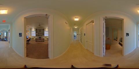 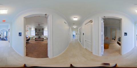 So anyway, I went to upload via the web interface ... I feel that you can control things better AND you could previously tie tours to the exterior street tours that may already exist. Although, I rechecked past tours and they've unlinked them from the street. WTH. https://www.google.com/streetview/businesses/publish/ This is what happened: Ingest was not successful. The following errors were detected: A prestitched pano does not meet the minimum size standard. Panos must be at least 6000 pixels in width. -- Great. Time to reimport the images to my phone to use the Street View App. I've heard that you cannot make 'See Inside' views from the Street View App -- in fact, my previous Theta uploads just show up as Photospheres in Google Maps. So - I'm cheating and resizing them from 5376x2688 to 6000x3000 when saving from Adobe Camera RAW. Since I'm applying sharpening and noise reduction, this isn't just a sloppy upsize, so it should be fine. -- Next, I've ingested them and Google seems to have used the GPS information in the photos to place them on the map. Problem is, it's pretty inaccurate. Many things are auto-stitched, some are even locked in place. I included a screen grab of the cluster of totally wrong placements. Time to manually correct this. -- Summary: Which Theta S does shoot HDR panos and auto-stitch them, like any photography, you'll want to edit them. They aren't actually professional streetview ready as the size is slightly too small. They could fix this with a firmware update to 'cheat' by upscaling the images a little bit. I love the Street View App, but I don't think it's the solution for professional Google Maps submissions. I've heard varying statements on the status of the 'Trusted Photographer' program. For now, I am still one and still have access to the injest system at: https://www.google.com/streetview/businesses/publish/ 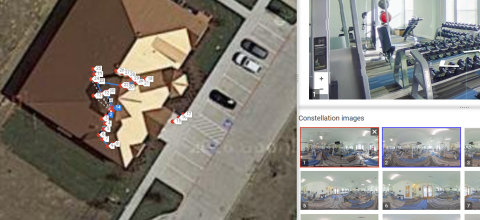 I may need to strip out all GPS information in order to sensibly use this. -- A bit underwhelmed by Theta S. |
||
| Post 17 • IP flag post | ||
|
Frisco, Texas |
Metroplex360 private msg quote post Address this user | |
| So one more note --- very annoying. The scans that were CLOSE together were automatically LOCKED. Apparently they were so close together that Google deems that using the incorrect THETA GPS information, there is no human way to argue that they are incorrect. This resulted in completely wrong markers. Easy fix -- delete the scenes that are automatically locked... no way to unlock them... no big deal. Just frustrating. | ||
| Post 18 • IP flag post | ||
|
Frisco, Texas |
Metroplex360 private msg quote post Address this user | |
| After wrestling to get the map markers in the right place, the scenes linking to each other correctly, and each pano always having a 'North', I've made a decent Google Street View 'Look Inside' tour. http://goo.gl/CZOaG3 The Ricoh Theta S is a convenient tool for shooting 1-shot panoramas. It is not a substitute for a Digital-SLR with a fisheye lens if you are looking for quality and depth of field. The images straight from the camera are decent, but not impressive. I believe that the GPS information is relative to the PHONE, not the CAMERA. Therefore, it makes sense to me that the phone should be connected to the Tripod, aligned to face North (I guess) and that images should be shot on a timer mode. I'm on the fence as to whether or not this should be sold on eBay as it just does not represent the quality of tours that I provide my clients. Here is the same place, via Matterport: https://my.matterport.com/show/?m=UeN7kkZHwpo This is a similar place, shot with a Nikon D7000, Manual Settings with Bracketing for HDR, Nikor 10.5DX Fisheye Lense, using a Nodal Ninja III MK2 panohead with 6 stops: http://goo.gl/hL4haJ -- The Matterport Tour excels for usability, mobile, and the dollhouse and floorplan view. The Nikon DSLR tour excels for image quality. The Ricoh Theta S tour excels for laziness. |
||
| Post 19 • IP flag post | ||
|
|
3Dwalkmethru private msg quote post Address this user | |
| @Metroplex360 the 360 quality is very poor .. are the photos processed from same take or different hardware. | ||
| Post 20 • IP flag post | ||
|
Frisco, Texas |
Metroplex360 private msg quote post Address this user | |
| The 360 Streetview is from the Ricoh Theta S, shot in HDR mode with the up-to-date- firmware and the Ricoh Theta App. I made edits and slightly enlarged them - you can see examples of before (straight from the camera) and after (edited in Adobe Camera RAW) in one of my previous posts on the thread. I'm not thrilled. The quality is far too low for my professional taste. I -can- charge clients more for higher quality and I'm getting ready to list this on eBay. |
||
| Post 21 • IP flag post | ||
|
Frisco, Texas |
Metroplex360 private msg quote post Address this user | |
| http://www.ebay.com/itm/-/331950838416? | ||
| Post 22 • IP flag post | ||

|
TrustedPhotoDC private msg quote post Address this user | |
| @metroplex The Street View Moderator has NEVER placed photospheres by using GPS. Lat/Lon metadata is not collected. Photospheres are placed by timestamp and spatial recognition. In the past 12 months, the AI has gotten very good. I normally do not need to do much, if any placement editing. (If you follow the distance recommendations it helps). Over 3 years ago, you were required to set your first image pointing north, but the that requirement is long gone. The Street View app does use lat/lon and it is based on the camera location, as the Theta has no GPS receiver. I've yet to se the app function as it was designed. Right now it is ok when connecting a few photospheres but going over 5 is just a world of hurt. On1 Photo provides a resize plugin that uses the Genuine Fractals algorithm to create enlargements. Works well with uprezing Theta images. My Street View Moderator uploads are native 11kx55k with Canon and 13kx6,5k with Sony. And in some cases the Theta - S works just fine at its native resolution. https://goo.gl/maps/LmMFvwhYRYK2 |
||
| Post 23 • IP flag post | ||
|
Frisco, Texas |
Metroplex360 private msg quote post Address this user | |
| Here are my 3 Ricoh Theta S Streetviews: https://goo.gl/maps/f8DsXH8Mc882 https://goo.gl/maps/3ndZ7szmL3P2 https://goo.gl/maps/X8t35ZAKoeP2 Here are my DSLR Streetviews of similar places: https://goo.gl/maps/bokGZW7c4NS2 https://goo.gl/maps/t9xQ4mUsBdS2 https://goo.gl/maps/5M5JBAzZqMM2 https://goo.gl/maps/VL3yYg2BMPB2 https://goo.gl/maps/66U9Hjb81cJ2 https://goo.gl/maps/KGPDKuLLkS42 https://goo.gl/maps/rip3Sxioz6F2 There's just no comparison. Except, my DSLR Street Views began as 'virtual tours' that were highlights. My client is now interested in having Street Views shot for other locations with 2-3x the # of scenes for a proper street view experience. The Theta is on eBay as the quality matters. |
||
| Post 24 • IP flag post | ||
|
|
TrustedPhotoDC private msg quote post Address this user | |
| @metroplex you need to work on not walking through walls and having photospheres connect, line of sight; forward and backwards(use F key to check). In a post publish QC world, these tours could still be flagged and removed(though highly doubtful). But if you are going talk quality, navigation should also be correct. | ||
| Post 25 • IP flag post | ||
|
Frisco, Texas |
Metroplex360 private msg quote post Address this user | |
| @TrustedPhotoDC - I totally know that my DSLR-based tours aren't close enough to be up to the standards that Google would prefer and am really happy that the tours are online. I hope they stay that way. I had originally shot the DSLR tours to play on the website with a custom interface. My use on them on Google Street View is done because I could. In the future, I will be shooting much closer! The Ricoh Theta tours were shot closer together. I'm new to Street View, but not to shooting panoramas. I'd love to see some of your tours -- you have a beautiful website but there's nothing on there. I need some good examples to take notes on |
||
| Post 26 • IP flag post | ||
|
|
TrustedPhotoDC private msg quote post Address this user | |
| @metroplex - website, the shoemaker's children always go barefoot. I keep saying next week I'll launch the new site, and replace the placeholder. Some past projects: Cornell Club of NY - https://goo.gl/maps/V5ny1RkBzAG2 Sedona Slate - https://goo.gl/maps/1L2XeGTvPTs Inova Children's Hospital - https://goo.gl/maps/2F5W3rQyJ5t Rams Head Onstage - https://goo.gl/maps/gjNKf8n6KQH2 The first three are shot with a 70D, 8-15 f/4. ISA 400 f/8 Rams Head is Sony A7RII, Metabones IV, 8-15 f/4. IS0 1200, f/8 Here is the Cornell Club's overlay tour: https://walkinto.in/tour/-JrvG2HKolbylrvf3BFjx I just shot essentially what is a city block for a a property management company, this will be a interesting tour. |
||
| Post 27 • IP flag post | ||
|
Frisco, Texas |
Metroplex360 private msg quote post Address this user | |
| @TrustedPhotoDC WOW. The Cornell Club is massive! How much post processing do you do on your images? I'm using Google Streetview's injest system and I have no idea how you did multiple floors. WOW. How did you do multiple floors?! | ||
| Post 28 • IP flag post | ||
|
Frisco, Texas |
Metroplex360 private msg quote post Address this user | |
| I wanted to clarify: Here are my 3 Ricoh Theta S Streetviews: Not HDR: https://goo.gl/maps/f8DsXH8Mc882 Old Firware / Non HDR: https://goo.gl/maps/3ndZ7szmL3P2 HDR: https://goo.gl/maps/X8t35ZAKoeP2 -- I still maintain that the aperture is too low and the image quality is not high enough for my standards, however, for the price of the Theta and price point that you can offer to your customers, there is still a market for this. I'd love to invite some other forum members to post some example tours where they experienced success. |
||
| Post 29 • IP flag post | ||
|
|
TrustedPhotoDC private msg quote post Address this user | |
| @metroplex Post post-processing - depends on the environment, client, what they are paying. but I, shoot RAW and then import and convert to DNG in LR(for archival).Export to JPG with a CA removed and White Balance. Multi exposures are tone mapped via batch in Photomantix Pro and exported as TIFF. TIFF stitched in PTGUi Pro, final images brought back into LR and edits in PS via a script so no seem is created in the edit. Export to JPG and then upload to Google Photos or build server based tour with Pano2VR Pro, etc. About the aperture, a wide open aperture is a characteristic of small sensors like the 1/2.3 in the Theta S. They need it or they will not be able to get enough light in for those tiny little pixels. Here are the number of the Theta S. You can see that it is focused to infinity, so the lack of sharpness has to be caused by something else which is the physical size of the sensor, circle of confusion and hyperfocal distance. 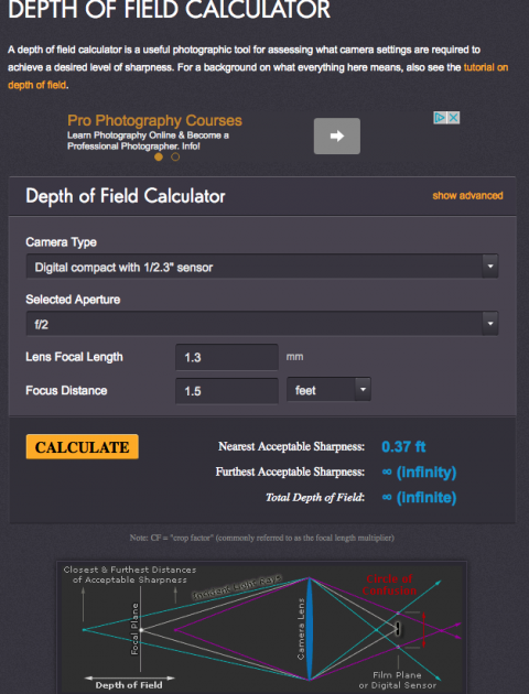 Some information https://www.quora.com/Why-do-phone-cameras-have-little-to-no-depth-of-field http://www.cambridgeincolour.com/learn-photography-concepts.htm https://en.wikipedia.org/wiki/Circle_of_confusion |
||
| Post 30 • IP flag post | ||
This topic is archived. Start new topic?