






Geo Week 2027: First Keynote Maps the Great Salt Lake21728
Pages:
1
 Owner, Owner,Managing Editor and Publisher of WGAN Forum and WGAN-TV Podcast Fairfield, California |
TomSparks private msg quote post Address this user | |
Geo Week is a We Get Around Network Marketing Partner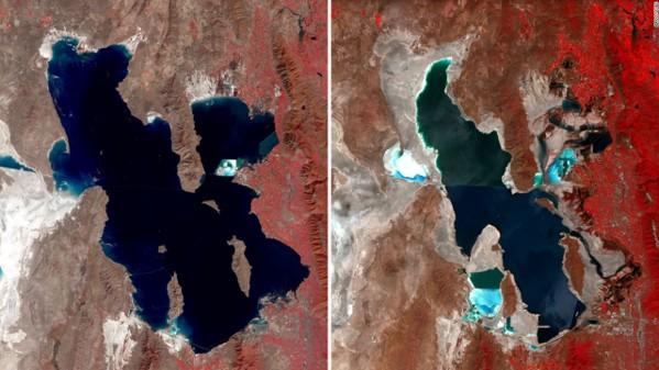 Image: USGS EROS imagery comparing the Great Salt Lake in 1987 and 2022 Geo Week 2027: First Keynote Maps the Great Salt Lake Geo Week has announced its first 2027 keynote, A Lake in Crisis: Mapping Utah's Great Salt Lake. It is a presentation and panel discussion on a large-scale bathymetric lidar project to map the lakebed, wetlands, and deeper-water environments of the Great Salt Lake. The keynote takes place during Geo Week 2027, February 23 to 25, 2027, at the Salt Palace Convention Center in Salt Lake City, Utah. The Great Salt Lake is shrinking fast, and the effects reach well beyond its shoreline. They touch migratory birds, the global aquaculture industry, and nearby population centers threatened by harmful dust from an exposed lakebed. As water levels change, knowing what lies beneath the surface matters more than ever. The Utah Geological Survey, Aero-Graphics, and Dewberry are among the partners on the project. The work combines Utah-based aerial acquisition, green-wavelength bathymetric lidar, multi-sensor planning, and advanced processing. The goal is to improve on legacy datasets and reveal lakebed details that have long been difficult to see. It is technically demanding work, complicated by murky water, shifting shorelines, and a lake that is constantly changing shape. "The challenges of data collection are immense... but where we do get data, that data provides a level of detail about the lakebed never seen before," said panelist Michael Vanden Berg of the Utah Geological Survey. The keynote panel features: Kelly Francis (moderator), Co-President, Aero-Graphics Bonnie Baxter, Director, Great Salt Lake Institute, Westminster College Josh Novac, Associate Vice President, Program Manager, Dewberry Michael Vanden Berg, Energy and Minerals Program Manager, Utah Geological Survey "The Great Salt Lake is local to Utah. Its importance is not," said Kelly Francis. "The Great Salt Lake is changing. Now we can measure how." The session covers why the lake's decline matters: who is affected, what is at risk, and why better lakebed information is essential for science, management, and public decision-making. Panelists will discuss the challenge of collecting data in a dynamic lake environment and what the new data is revealing about microbialite reef structures, lakebed morphology, wetlands, and geologic features, along with future research needs. If you plan capture work around conditions you can't control, this one is worth a seat. "Whatever your industry, you'll recognize the problems this team is solving, and the solutions apply well beyond the Great Salt Lake," said Carla Lauter, Senior Content Manager at Geo Week. The full conference program will be announced soon. Registration is open now with Super Saver Pricing. Learn more and register for Geo Week 2027: https://wgan.info/geoweek-forum About Geo Week: Geo Week brings together geospatial and mapping professionals for a conference program and tradeshow floor covering expert insights, real-world case studies, tools, and peer-to-peer networking. Geo Week 2027 takes place February 23 to 25, 2027, at the Salt Palace Convention Center in Salt Lake City, Utah. Geo Week is produced by Geo Week News and is part of Diversified's technology portfolio. Topics covered in this post include: Geo Week 2027, Great Salt Lake, bathymetric lidar, Utah Geological Survey, Aero-Graphics, Dewberry, Great Salt Lake Institute, Salt Palace Convention Center Are you heading to Geo Week 2027 in Salt Lake City? Have you worked with bathymetric lidar or multi-sensor capture? Share your experience in the comments below. |
||
| Post 1 • IP flag post | ||
Pages:
1