


AuraGo by Q3D Sensing: A “Pro” LiDAR Scanner That Clips to Your Phone21471
Pages:
1
 Owner, Owner,Managing Editor and Publisher of WGAN Forum and WGAN-TV Podcast Fairfield, California |
TomSparks private msg quote post Address this user | |
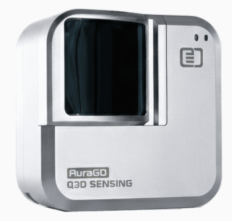 AuraGo by Q3D Sensing: A “Pro” LiDAR Scanner That Clips to Your Phone (Up to 30m Range) Hi Everbody, NEW TOOL ALERT. Q3D Sensing just announced AuraGO™, a pocket size, long range LiDAR 3D capture sensor that attaches to your smartphone or tablet. The goal is to fill the gap between phone based LiDAR scanning that is convenient but limited, and pro scanners that are powerful but bulky, expensive, and not always in every field tech’s hands. Q3D is positioning AuraGO as professional 3D capture with smartphone ease of use. What it is (plain English) AuraGO is a mobile depth sensor and LiDAR scanner that snaps onto your phone or tablet, and the phone does the heavy lifting such as power, processing, display, and RGB capture. The sensor focuses on depth capture while the mobile device acts as the “brains.” The headline specs (why AEC folks should care) From Q3D’s published specs, AuraGO claims an outdoor capable range up to about 30 meters, with stated accuracy of ±3 cm at 10m and precision of ±2 cm at 10m. Q3D also lists a compact form factor and lightweight build, and notes it can be powered by the phone or an external battery. They also indicate the system is Class 1 Laser. Point cloud and workflow (this is the key for WGAN) For many of us, the deciding factor is not just capture, it is exports and workflow compatibility. Q3D says their Q3D Scan app supports export to industry standard formats including E57 plus multiple common point cloud formats, and they also list RCS and POD from Windows only. They further note that Q3D Scan includes measurement and geo referencing capabilities with options such as coded targets, survey control, and constraints, which reads as AEC minded compared to many casual scanning apps. Also worth noting, Q3D says Q3D Scan is launching in partnership with DotProduct, and AuraGO integrates with the Dot3D ecosystem. Pricing and availability (preorder) Q3D lists AuraGO at $3,990 with a $500 pre order deposit, and they indicate delivery starting Q2 2026. More details here: https://wgan.info/Q3dSensingAuraGo The AI angle (quick take) Dr. Tianyue Yu’s framing is that AI based reconstructions can look great visually, but measurements can drift when depth is essentially a best guess. Their pitch is sensor informed intelligence where you embed metric ground truth into the capture process so the model stays stable and measurable, not just visually impressive. Who this could be for (WGAN reality check) If AuraGO performs as advertised, it looks most interesting for AEC teams that want faster site capture, as built documentation, progress tracking, and point cloud deliverables without deploying a full terrestrial scanner every time. It also has obvious overlap with facilities work, industrial documentation, public safety capture, and even real estate and design when measurable data matters. Questions for the WGAN community Would you trust a stated ±3 cm at 10m for your typical use cases, and what would you need to see to take this seriously? Are exports like E57 enough, or do you require specific deliverables like RCS workflows? What matters most to you for a tool like this: range, speed, or clean registration and loop closure? And if you already use Dot3D workflows, does this integration change your interest level? My ask (so we can make this useful) If you want WGAN to pursue a deeper look, tell me what you would want first: a sample dataset download, side by side comparisons versus phone LiDAR, or comparisons versus tools like BLK, Matterport Pro3, Leica, or Trimble. If there is enough interest, I will try to get Q3D to answer community questions and ideally share real sample files. Watch Dr. Tianyue Yu introduce the AuraGo at Geo Week 2026. |
||
| Post 1 • IP flag post | ||
Pages:
1