


Chart: Matterport Versus REALSEE - Comparing 70+ Features Side-by-Side19632
Pages:
1
 WGAN Forum WGAN ForumFounder and Advisor Atlanta, Georgia |
DanSmigrod private msg quote post Address this user | |
| Chart: Matterport Versus REALSEE - Comparing 70+ Features Side-by-Side Hi All, I created a Google Sheet (chart) to compare Matterport versus [Realsee on: 1. 70+ Features 2. Pricing I enabled comments within the Google sheet so you can let me know: 1. corrections 2. revisions 3. suggestions Your thoughts? Best, Dan |
||
| Post 1 • IP flag post | ||
|
|
kinetix private msg quote post Address this user | |
| wow! | ||
| Post 2 • IP flag post | ||
|
WGAN Forum Founder and Advisor Atlanta, Georgia |
DanSmigrod private msg quote post Address this user | |
| @kinetix ... Quote: Originally Posted by kinetix WOW in what way? Best, Dan |
||
| Post 3 • IP flag post | ||
 WGAN WGANStandard Member Los Angeles |
Home3D private msg quote post Address this user | |
| Fantastic job, very detailed, on the Google sheet. I've added some comments and questions. Also, I would love a detailed description of what you can do with these ports on the Galois. The center "charge" port is obvious, but what about the USB-A "Data" port and the microSD card slot. Assuming these enable certain functions, please include these in the Line Item details about the Galois. Big difference from the MP Pro 3 which has no data-moving functions except through the Capture app by Wifi. 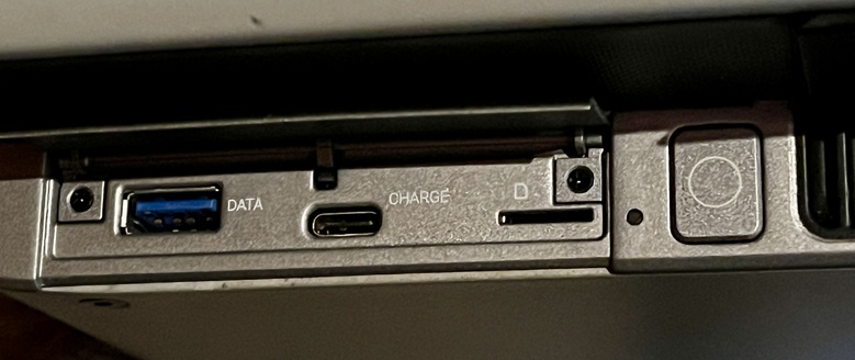 |
||
| Post 4 • IP flag post | ||
|
WGAN Forum Founder and Advisor Atlanta, Georgia |
DanSmigrod private msg quote post Address this user | |
| @Luona_REALSEE Can you answer these @Home3D questions? Quote: Originally Posted by @Home3D Best, Dan |
||
| Post 5 • IP flag post | ||
|
WGAN Forum Founder and Advisor Atlanta, Georgia |
DanSmigrod private msg quote post Address this user | |
| @Luona_REALSEE Can you answer these questions that @Home3D asked in the Google Sheet (chart)? 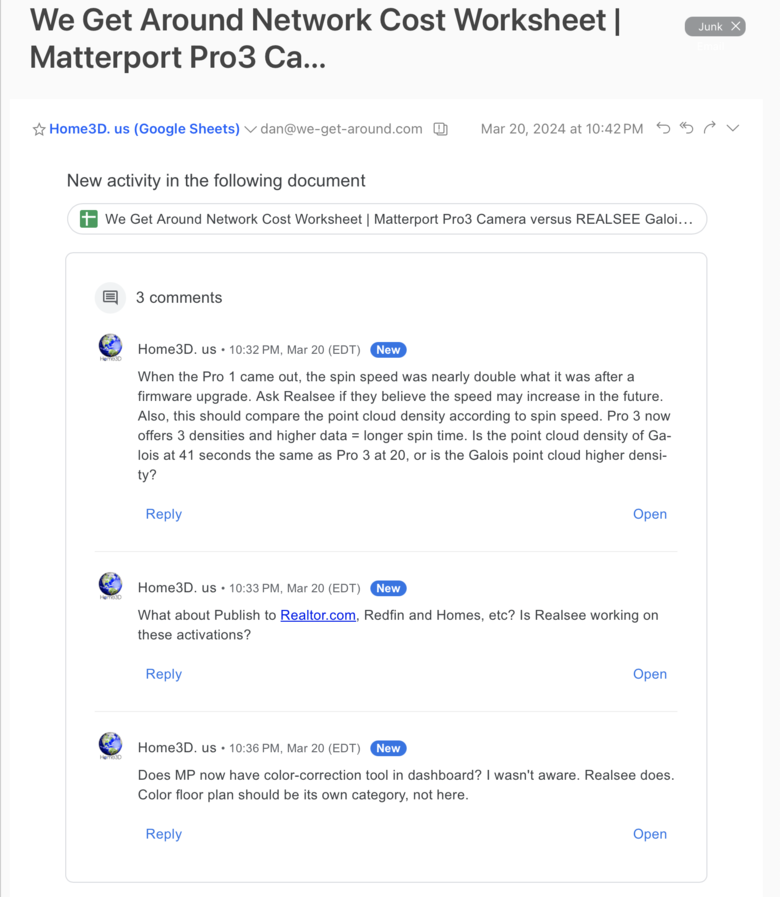 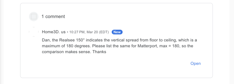 thanks, Dan |
||
| Post 6 • IP flag post | ||

Beijing |
Luona_REALSEE private msg quote post Address this user | |
| @Home3D Hi Thank you for the question The data port and the microSD card slot are designs we've implemented in advance to meet potential future use cases. We will respond to the questions you raised in the worksheet directly within the worksheet. Thank you once again for your attention and for using our services:) Also, Realsee Galois single-point scanning speed improvement and 5 bracketing will be implemented around May. Thanks, Luona |
||
| Post 7 • IP flag post | ||
|
WGAN Standard Member Los Angeles |
Home3D private msg quote post Address this user | |
| Thank you, @Luona_REALSEE for your quick reply. I look forward to learning more. Brilliant idea to give the Galois the USB and microSD ports for future developments. Fantastic. Another question: I understand that any equirectangular 360° pano can be uploaded to a Realsee model, such as an aerial drone pano. Can these panos be manually connected to the the nearest, or a convenient NODE within the Realsee model? For example, scan a house with the Galois including some outdoor nodes such as a balcony or patio. Can an aerial pano with clear visibility of the patio be connected, such than in the aerial pano a visitor will see a hotspot icon on the patio they can click to, and when in the patio node, you see a hotspot in the sky where the drone was when the aerial pano was captured? Thanks! |
||
| Post 8 • IP flag post | ||
|
WGAN Forum Founder and Advisor Atlanta, Georgia |
DanSmigrod private msg quote post Address this user | |
| Hi All, To make it easy to see the comment exchange in this WGAN Google Sheet: @Home3D writes: When the [Matterport] Pro1 came out, the spin speed was nearly double what it was after a firmware upgrade. Ask Realsee if they believe the speed may increase in the future. Also, this should compare the point cloud density according to spin speed. [Matterport] Pro3 now offers 3 densities and higher data = longer spin time. Is the point cloud density of Galois at 41 seconds the same as Pro3 at 20, or is the Galois point cloud higher density? @Luona_REALSEE writes: Hi Realsee Galois single-point scanning speed improvement and 5 bracketing will be implemented around May [2024]. @DanSmigrod writes: About the point cloud density of the Matterport Pro3 Camera versus the REALSEE Galois LiDAR Camera, I will plan to loan the REALSEE Galois LiDAR Camera to a WGAN Member that is intimate with point cloud density (uses point clouds); has a Matterport Pro3 Camera and would be willing to take the REALSEE Galois LiDAR Camera for a spin to specifically compare Matterport Pro3 Camera versus REALSEE Galois LiDAR Camera point cloud density (in context to actual uses cases.) Thanks for your patience since I'll need the loaner back from you to do this! [/i] --- @Home3D writes: What about Publish to Realtor.com, Redfin and Homes.combold text, etc? Is Realsee working on these activations? @DanSmigrod writes: For clarification, Matterport offers seamless publishing integration with: 1. Redfin 2. Realtor.com 3. Homes.com 4. VRBO 5. HomeAway 360 6. Google Street View 7. Note: Zillow is not specifically listed as a seamless integration (no "publish to" button) @Luona_REALSEE writes: The realtor has mentioned that the listing includes a 3D tour with a Virtual Tour badge (including Realsee virtual tour). In the "Facts & Features" section on Zillow, there will be a virtual tour link displayed. Similarly, in the property details section on Redfin, a virtual tour link will be provided. Realsee is continuously working on improving services and welcome any valuable suggestions. --- @Home3D writes: Does MP now have color-correction tool in dashboard? I wasn't aware. Realsee does. Color floor plan should be its own category, not here. @DanSmigrod writes: Matterport color-correction is available via 3rd Party companies that have licensed the Matterport SDK. For clarification, Matterport does not offer this feature directly. As you pointed out, REALSEE does offer color-correction in the REALSEE Console. Matterport calls their "console" --> Workshop. I will breakout floor plans in the sheet: Black and White Floor Plans and Color Floor Plans. (Two separate line items.) As you take the REALSEE GALOIS LiDAR Camera and REALSEE Platform for a spin, please do alert me to any additional line item suggestions and/or correcctions. --- @Home3D writes: Dan, the Realsee 150° indicates the vertical spread from floor to ceiling, which is a maximum of 180 degrees. Please list the same for Matterport, max = 180, so the comparison makes sense. Thanks @DanSmigrod writes: I will need to figure out this puzzle. Both companies confuse me regarding the Zenith and Nadir Field of View (Fov) question. Worth noting that REALSEE has an AI option to "magic fill" the Zenith and Nadir. Perhaps you can do a post that has one: 1. one Pro3 scan 2. one REALSEE scan without AI "magic fill" 3. one REALSEE scan with AI "magic fill After you do the test, how important is this to you? Matterport Pro3 Tech Specs are a Field of View (FoV) of 360 degrees H / 295 degrees V [H = not sure?] [V is likely the Vertical for Zenith and Nadir, but it is unclear to me.] Thanks for asking great questions. Enjoy your weekend, Dan |
||
| Post 9 • IP flag post | ||
|
WGAN Standard Member Los Angeles |
Home3D private msg quote post Address this user | |
| I've posted a couple more questions to Luona through the Google sheet. 360° panoramas have two coverage dimentions, 360° horizontally (kinda necessary to make a 360° image!) and 180° vertically, essentially for coverage from the "south pole" to the "north pole". Since you can't really have a "pano" without horizonally covering 360°, the variable with different cameras is the vertical, 180° being complete. MP claiming 295° is really a misnomer. 360 - 295 = 65° NOT COVERED, which if evenly split between top and bottom would leave 32.5° missing at the top and 32.5° missing at the bottom. This sounds off for me. I think the MP holes at top and bottom are smaller than that. I'll test this. If Realsee claims 150° coverage, that means 30° of the 180° vertical is covered, leaving about a 15° hole at top and bottom if split evenly, which would be superior to MP's numbers. This actually sounds close, though I haven't tested yet. Anyway, I'll do a side-by-side as I rather suspect BOTH claims are off a bit, whether better or worse. One-shot cameras like Theta Z1, X and Insta360s all provide full 360°/180° coverage, which is why you see the tripod. It's ALL there! Same with a full-frame Sony on Nodal Ninja which I use a lot. If you regularly work with equirectangular panos, you know one hard and fast rule. Panos MUST be exactly 2:1 ratio in pixels, precisely. They can be 100x50, 1500x750, or 235,678x117,839. That second, vertical pixel dimension MUST be exactly 1/2 of the first, horizontal dimension. If it's off by even 1 pixel, you don't have an equirectagular panos and apps will probably spit it out. As long as this math is correct, panos will work. Footnote, some apps have limits in pixel size, 3DVista I'm told has none. However the bigger they are, the more an app may bog down. |
||
| Post 10 • IP flag post | ||
|
Beijing |
Luona_REALSEE private msg quote post Address this user | |
| @Home3D HI thank you for the question, I think what you asked is about the connection between Pano and the virtual tour. The hotspot feature in Realsee editor could solve this I think In this case, you could enter into an aerial virtual tour first, then you could find 2 hotspots to click and then jump into another 2 virtual tours respectively. How could we do this? Step 1: Use the 'pano to 3D' feature on Realsee console, upload the aerial pano, and generate the aerial 3D tour first; then use the 'space' label in the hotspot part in the Realsee editor to add connected virtual tours. (The 'Space' label could connect related virtual tours, allowing you to jump from one to another) pic1: Pano to 3D interface 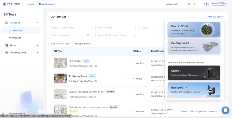 pic2: 'space' label 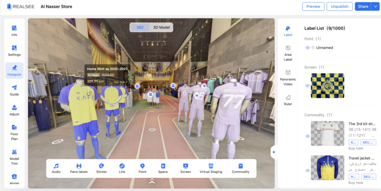 AND also, there is another way to combine the Pano and virtual tour, which is adding the ' Pano label'. Pls check the following pic, you could find the 'pano label' on editor-hotspot, and then you could upload pano as a tag in a specific place in the virtual tour to indicate that there is a pano related to that point. 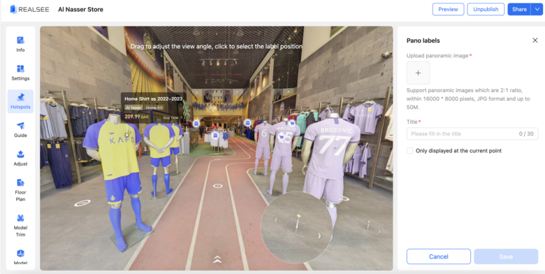 Hope this answers your question, feel free to try this out, thank you! Regards, Luona |
||
| Post 11 • IP flag post | ||
Pages:
1This topic is archived. Start new topic?