


Using the Polycam app to scan objects for Virtual Staging18676
Pages:
1
 CAPTUR3D CAPTUR3DTeam Melbourne, Australia |
AlexHitchcock private msg quote post Address this user | |
| Hi WGAN crew, I just wanted to share this workflow for scanning an object with the Polycam app to create a 3D asset file, and then uploading the asset to the CAPTUR3D Creator Studio for Virtual Staging of Matterport models. The quality of the asset came out really well! https://vimeo.com/817509436/008a9db7d9?share=copy If you haven't tried CAPTUR3D yet, you can use this WGAN referral link for $90 worth of free credits when you sign up |
||
| Post 1 • IP flag post | ||

|
Skeeter private msg quote post Address this user | |
| Mahalo for that. I'm going to try it out tomorrow. Going to go to a furniture store and get some assets. | ||
| Post 2 • IP flag post | ||
 WGAN Fan WGAN FanClub Member Queensland, Australia |
Wingman private msg quote post Address this user | |
| Polycam is fantastic and they even do Lidar scanning for free and only ask you to have a paid account for photogrammetry. However they still include some photogrammetry for free. I recently used it for my own need to see what my deck will look like when I put it back. The only problem I forgot to scan a bit more to show rock steps and did not remove some staff. Here is a mesh model as captured by my iPad Pro Lidar. https://poly.cam/capture/04D0F7B5-6555-4762-9B2C-5F6A06E29933 And this is what it will look like as a render from Blender 3D. I did not fill some gaps in Blender 3D but it is simply because I do not want to spend too much time on it. And I am still thinking whether I want the deck to go around a half of the pool or just with a small gap which will be covered with payers(as it was before) 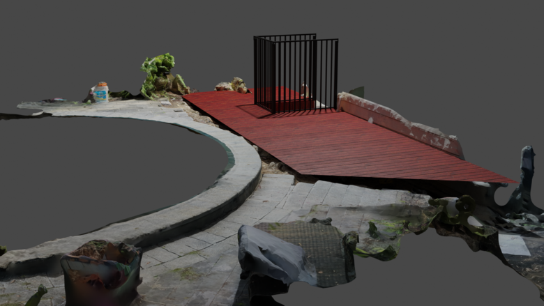 Unfortunately and it is not a Polycam's fault lidar scanning won't work with scanning big outdoor spaces and interiors. This is what Apple needs to fix because this problem happens in any software that is using Apple API for built in lidar. The problem is while scanning big spaces Ipad/IPhone is loosing its position in space and starts ruining everything. @AlexHitchcock: Have you tried attach a big chank of mesh of something scanned outdoor to a matterport tour in your Captur3D? |
||
| Post 3 • IP flag post | ||
|
CAPTUR3D Team Melbourne, Australia |
AlexHitchcock private msg quote post Address this user | |
| Hi @wingman we did a webinar with Michael Goula a few months ago where we ran through the general workflow for integrating a photogrammetry model from drone shots of the exterior of the property into Captur3d. I've included Michael's example here: https://captur3d.io/view/ingos-3d/domcek?fbclid=IwAR0IJ-p3KSrF2EldqgwKML9eRBvSyVL6UuyFhlVYEG5SmK3Rzmtvolpk9jo Webinar is here: https://www.youtube.com/watch?v=m6k2X9mlaVg&ab_channel=MichalGula |
||
| Post 4 • IP flag post | ||
|
WGAN Fan Club Member Queensland, Australia |
Wingman private msg quote post Address this user | |
| You are right. Once you I saw your reply I recalled how I watched that video where you added aerial 3d model to a Matterport tour. Not that I need it now but it is good to know it works that way too. | ||
| Post 5 • IP flag post | ||

|
inmerso3D private msg quote post Address this user | |
@AlexHitchcock Quote:Originally Posted by AlexHitchcock Great! |
||
| Post 6 • IP flag post | ||
Pages:
1This topic is archived. Start new topic?