


Scaling Asteroom 2D Floor Plans correctly for planning applications18010
Pages:
1|
|
pscott private msg quote post Address this user | |
| Hi, I run a Holiday Home Agency in Scotland and have been doing a few 360 Tours for clients (property owners) using the Asteroom Software and the Iphone 12 Pro on the Asteroom head - results have been good although thinking about buying a 2nd hand Theta X or Z to improve the quality of the images. I'm an experienced self taught DSLR photographer and use Lightroom Classic for editing. Example see bottom of listing for Asteroom tour: Example Iphone Pro 12 Tour There is new licensing that has come into force which requires that we provide a floor plan (along with the application) - 1:100 Scale on A4 Paper size which the local planning office then uses to measure total floor space and also ratio of bedrooms to bathrooms and other facilities. Asteroom have been able to provide me with a floor plan with the 1:100 Scale - I can only download a jpeg from their website - The problem with this is getting the Scale to work when the planning department print off the image see photograph below the scale is not correct - Normally what I would do is produce a PDF that is scaled correctly for A4 Paper and I also understand the limitations of JPEGs as they are not vector file like an EPS - I use a Mac for business but do also have a windows 10 machine. Any suggestions on how I do these floor plans to scale? - using workflow with Asteroom or use another software provider? - CAD Software - trying to keep costs low as this legislation is an extra burden during cost of living Crisis in the UK. 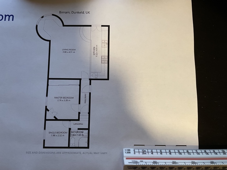 |
||
| Post 1 • IP flag post | ||
 SCAN TO CAD FILE SERVICE SCAN TO CAD FILE SERVICE
|
Baezeni private msg quote post Address this user | |
| Try Inkscape its free and work on both mentioned platforms. Its a general prpose vector draw program and you need to invest time to learn it for your purpose. If you want to take a step up the ladder to a more dedicated floorplan program www.roomsketcher.com is one of the easiest and fastest and most flexible. Its commercial but affordable. You can as well send it to contact@baezeni.com and we will make you a correct scaled construction drawing in any wished cad vector format and send you back within your morning the next workday. |
||
| Post 2 • IP flag post | ||
|
|
ron0987 private msg quote post Address this user | |
| I am not familiar with Inkscape, but I take PDF files and convert them to a DFX or DWG file type and then download it into a CAD program. I convert the file thru a program Zamzar an online program. Zamzar will convert two files a day online for free. I take the downloaded usually a DFX and import it into my CAD program lock the view as one item and then use the scale option. For me this only takes a few minutes and I have found my x and y axis of my diagram is ok if I use the snap function in the CAD program for the scaling set up to pick the exact points on the scale when sizing the converted file. I then have the option to export as an exact scale PDF or a few other file formats. Hopefully that helps. | ||
| Post 3 • IP flag post | ||

|
HomeExtensionPlans private msg quote post Address this user | |
| @pscott I have had the same problem with my local Planning Departments with Ordnance Survey Plans for location and block plans (I'm a Chartered Architect). Its annoying as the scale bar is there for a reason, it doesn't have to scale exactly with a scale rule, you can make up your own scale bar with a scrap piece of paper, thats the whole point of having a scale bar shown on the drawings. Jpegs never scale correctly, only pdfs or Autocad files such as dwg or dxf. If you can get a pdf and you ever need a cad file I can format pdfs directly in Autocad to whatever scale you may need with your own branding / title block, etc. |
||
| Post 4 • IP flag post | ||

|
AnjumDesign private msg quote post Address this user | |
| this plan could be inserted into cad software and scaled accordingly and then could be printed on correct 1:100 scale. Let me know if you need assistance and I will be happy to demonstrate it to you. | ||
| Post 5 • IP flag post | ||
Pages:
1This topic is archived. Start new topic?