


Caves: 230 feet (70m) below the surface179
Pages:
1

|
Jacques private msg quote post Address this user | |
| Hello, I spent my saturday morning in caves, trying to figure out how my Matterport 3D camera would manage to deal with such a dark environment. Clearly the main issue is the lack (and quality) of light... Some caves' structures are sometimes moving over time and today scientists are manually studying these natural evolutions, which is very time consuming. The idea is to try to help them by providing 3D models (.obj files) of caves on a periodic basis (every 2-3 years for instance) and developp a piece of software to compare successive 3D models of a particular caves over time, to focus on what changed. However, here is one of the first 3D scanned caves ever I guess... One room: another room: |
||
| Post 1 • IP flag post | ||
|
|
Jacques private msg quote post Address this user | |
| Just in case: does anyone have an idea of how two .obj files of a same room could be compared? That supposes analysing the .obj structure and maybe reporting major differences... In fact I'm not even sure that this can be done as successive scans of a particular room would probably never be the same, assuming that sweeps would probably never be executed at the exact same place in the room... |
||
| Post 2 • IP flag post | ||

|
Jamie private msg quote post Address this user | |
| What I've done in low or no light is to use a flood light or lantern on top of the scanner. It works quite well |
||
| Post 3 • IP flag post | ||

|
JohnBecker private msg quote post Address this user | |
| Jacques, that's a great idea! No idea about how to work with the .obj files, but I think I'm going to have to get in touch with the people who run the local cave. How did you hide? Did you walk around behind the camera as it turned? |
||
| Post 4 • IP flag post | ||
|
|
vincent private msg quote post Address this user | |
| I have been transiting the object files to CAD You might consider that approach I think if you can get them into navis there are some limited tools for comparison of point clouds. Maybe start be speaking to someone with some extensive construction coordination experience dealing with point clouds. |
||
| Post 5 • IP flag post | ||
|
|
Jacques private msg quote post Address this user | |
Quote:Originally Posted by JohnBecker Hi John, I did hide in other rooms touching theses ones. |
||
| Post 6 • IP flag post | ||
|
|
Jacques private msg quote post Address this user | |
Quote:Originally Posted by vincent Thank you for your answer Vincent. You mentionned "Navis", do you mean "Autodesk Navisworks" ? I also found this URL: http://initialaec.com/using-navisworks-to-compare-models/ I've read that a "Autodesk Navisworks Freedom" is freely downloadable, I'll first try to import a converted .obj file and from there, I'll see what can be done. I'll also try to find and discuss with people dealing with point clouds, good idea! |
||
| Post 7 • IP flag post | ||
|
|
vincent private msg quote post Address this user | |
| Yes Autodesk Navisworks I am not sure the freedom version will do the trick. Look closely at the feature set and capabilities of the Navis platforms. I used a beta version of Autodesk Momento that has more export versatility to get any file to CAD I am interested to know the "measure" of movement you are looking to detect. Generally it seems to me and i hate to say it here but best practice for measuring and comparing minutia changes would be a point cloud scanner. I have known of groups that set these fixed mounted in one position for long periods of time running on a schedule. Set to scan periodically and automatically compare to previous scans to alarm is settlement or movement occurs beyond a preset tolerance. I think that only the highest end scanners are capable of this process but I could be wrong. I can share contact info for a gentleman that is an expert on this particular subject if you need. |
||
| Post 8 • IP flag post | ||
|
|
Jacques private msg quote post Address this user | |
| Tomorrow I'll be on business trip for a week, therefore I would only be able to work again on this subject after my return. At this point I'm just trying to determinate what can be done in this area with a Matterport camera and if it looks promising I will present this kind of "proof of concept" to the team in charge of stydying these particular caves. The 1" precision announced by Matterport didn't seem to frighten them so far, however I'm convinced that your right regarding the 3D laser point scanner. As the price is clearly not in the same range, depending on the exact needs of this team, maybe our Matterport camera could nevertheless play a role. If I need to contact someone on this particular subject; I'll come back to you and ask for the contact info for this gentleman. Thanks for proposing. |
||
| Post 9 • IP flag post | ||

|
ccctucker private msg quote post Address this user | |
| I use a program called cloud compare. Its free and it will accept .obj files. Thats what i use to make 2d drawings. it will allow you to cut out part of model to see inside or for me, i can separate the floors and look into it from above. you can also use Meshlab to help fix your model to be able to print a 3d model from it. I have not delved into that arena, but there is plenty of youtube tutorials. If you want any help with cloud compare, i can walk you through it over the phone. why your images are dark is because the camera needs light to create the "skin" that it will put over the mesh. I suspect that you can see the cave if you open the OBJ file in a program like Cloud Compare. |
||
| Post 10 • IP flag post | ||
|
|
Jacques private msg quote post Address this user | |
| Thank you ccctucker for this valuable information. Tomorrow I'll be on business trip for a week, therefore I would only be able to work again on this subject after my return. Then, if I need any help, I'll come back to you. |
||
| Post 11 • IP flag post | ||
 Nodal Ninja Nodal NinjaFounder |
Bill private msg quote post Address this user | |
| Maybe a bit off topic but I wanted to share a link to Luke Farrer's video on how he created a 3D model of a cave using LiDAR and high resolution photography. It gives us a glimpse of what's possible with the technology. |
||
| Post 12 • IP flag post | ||
|
|
ccctucker private msg quote post Address this user | |
| That's the same type of equipment I use in my other job. It's great, but really expensive. | ||
| Post 13 • IP flag post | ||
|
|
Jamie private msg quote post Address this user | |
| Almost like the faro focus. What's the laser unit he's using Bill? |
||
| Post 14 • IP flag post | ||
|
|
Jacques private msg quote post Address this user | |
Quote:Originally Posted by Bill Wow, great images Bill! As you said we're not in the same price range... |
||
| Post 15 • IP flag post | ||
|
|
Jacques private msg quote post Address this user | |
Quote:Originally Posted by Jacques I finally woke up earlier today and did a first try with Cloud Compare. Impressive (free) piece of software! Juste after import: 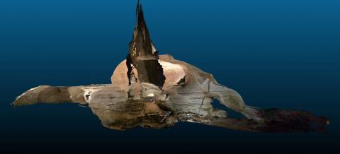 First comparison (2 scans of the same room) - Dec scale: 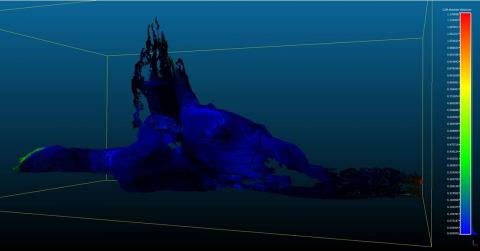 Second comparison (2 scans of the same room) - Log scale: 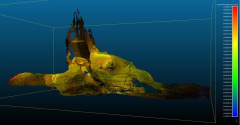 That looks promising! |
||
| Post 16 • IP flag post | ||
|
Nodal Ninja Founder |
Bill private msg quote post Address this user | |
| I believe Luke used the Faro laser scanner (don't quote me) but true to say the money invested in equipment like this is huge and beyond reach of most not to mention the technical know how. His most recent project was successfully funded through crowd funding source. These are projects of extreme and viewed by many with great interest. Matterport gives us a taste of these capabilities. | ||
| Post 17 • IP flag post | ||
|
|
Jamie private msg quote post Address this user | |
| The focus is a fantastic bit of gear. I guess with a 50k+ price tag it would want to be | ||
| Post 18 • IP flag post | ||
|
|
PixelFig private msg quote post Address this user | |
| Jacques - Greetings from the Var. Your question reminded me of MIT research in this video - http://bits.blogs.nytimes.com/2013/02/27/scientists-uncover-invisible-motion-in-video/?_r=0 It does not use scanning technology as such but accentuated video or timelapse could prove to be cheaper than laser tech. |
||
| Post 19 • IP flag post | ||
Pages:
1This topic is archived. Start new topic?