


Leica 3D Scanner on Boston Dynamics Spot Robot for Fast, Easy Capture14377
Pages:
1
 WGAN Forum WGAN ForumFounder and Advisor Atlanta, Georgia |
DanSmigrod private msg quote post Address this user | |
| Media Release --- 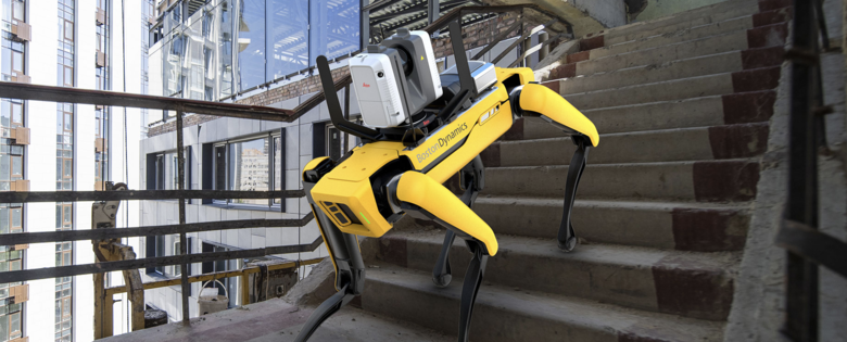 Image courtesy of Leica Geosystems Leica Geosystems Offers Mobile, Agile 3D Reality Capture Solution for Boston Dynamics Spot Laser Scanning Industry Leader Combines RTC360 Visual SLAM and LiDAR with Spot Agile Mobile Robot for Fast and Easy-to-Use Reality Capture (Heerbrugg, Switzerland, 25 February 2021) Leica Geosystems, part of Hexagon, leader in 3D scanning technology today announced a reality capture solution for a variety of industries. By combining Boston Dynamics agile mobile robot Spot with the industry-proven Leica RTC360 3D laser scanner, scanning time spent by human operators is significantly reduced by programming the devices to repeat automated scanning paths through sites. This requires minimal monitoring by the user, allowing for increased scanning efficiency, productivity, and flexibility when planning reality capture tasks. Professionals in many different industries such as construction, manufacturing, facility management, public safety, defense, media and entertainment or any other industry with autonomous scanning needs can benefit from programmed scanning tasks, especially for locations that must be repeatedly scanned for up-to-date digital twins. Whenever accurate, reliable, and up-to-date 3D data is needed, the integration of Leica Geosystems’ RTC360 technology onto the Spot mobile robot provides significant additional customer value in a variety of industries and jobsite scenarios where flexible and agile laser scanning workflows are required. Spot’s ability to cover many types of terrain and the RTC360’s VIS (Visual Inertial System) creates this solution. While mounted atop Spot, the Leica RTC360’s VIS technology uses five cameras to track the scanner’s movement within the site between the scans. The VIS system provides an unmatched level of accurate and automated in-field pre-registration to streamline the reality capture process. While scanning, the user only needs to trigger each scan remotely via mobile device while Spot and the RTC360 navigate the programmed scanning path. The RTC360’s VIS technology creates an easier, faster scanning workflow. For example, users can essentially “walk” Spot through a site by using a mobile device to control the RTC360 scanner. This allows users to speed up routine as-built documentation tasks and capture data accurately, quickly, and frequently. It also automatically combines captured scan data from station to station as it knows its location in space, resulting in a completely pre-registered point cloud of the entire scanned site, which makes final data processing in the office much easier. "Making the RTC360 and VIS technology available on Spot is a great step forward from Leica Geosystems to provide autonomous reality capture solutions”, said Thomas Harring, CEO of Leica Geosystems, “Customers benefit from the user-friendly combination of both devices, our relationships with leading technology experts enable us to accelerate our delivery of these technologies while addressing the growing need for autonomy, automation of construction processes, and precision in 3D scanning.” Combining Boston Dynamics Spot with the RTC360 creates a mobile scanning solution that saves time because Spot does the walking and stationing of individual scans instead of the user. Once Spot and the RTC360 learn a programmed scanning route through a location, they can more easily and quickly repeat that route for regular scanning. The remote control of the Leica RTC360 via a mobile device allows Spot’s agility and mobility to cover terrain that may be difficult or hazardous for a human operator. The new Leica RTC360 for Spot includes all needed installation accessories, a protection bar for the scanner cameras, and Leica Geosystems software ensuring that users can get started within minutes. The RTC360 installation kit for Spot is available through Leica Geosystems distribution channels and Spot through Boston Dynamics. Further information can be found at: Leica RTC360 3D Laser Scanner | Leica Geosystems (leica-geosystems.com) Source: Hexagon | Leica Geosystem Newsroom --- Your thoughts? Best, Dan |
||
| Post 1 • IP flag post | ||
 WGAN WGANStandard Member Los Angeles |
Home3D private msg quote post Address this user | |
| Very cool. I love watching the Boston Dynamics videos. As the article states, this is a solid development for projects which require repeated scanning periodically through stages of construction. "Spot" can figure out and recall exactly where s/he was on the first scan when returning for the 2nd, 3rd, etc. But I'm not too concerned about this interfering with our work, at least for several years. Does anyone know what a "Spot" sells for? I expect it won't hasten a move into residential real estate until "Spot's" cost comes down a lot. Maybe "Spot v.4 or 5" perhaps. |
||
| Post 2 • IP flag post | ||
|
|
castaway private msg quote post Address this user | |
| Post 3 • IP flag post | ||
|
WGAN Standard Member Los Angeles |
Home3D private msg quote post Address this user | |
| Harking back to the days of intriguing WGAN loaner programs... Dan if Boston Dynamics "loans" you a Spot, sign me up. On the other hand, I'll defer to The Great Tosolini (he's the closest thing to a WGAN magician) who will no doubt find even more amazing applications for it. |
||
| Post 4 • IP flag post | ||
|
WGAN Forum Founder and Advisor Atlanta, Georgia |
DanSmigrod private msg quote post Address this user | |
Quote:Originally Posted by @Home3D You are on the list! (Not that I am expecting to get a Spot to loan out!) Dan |
||
| Post 5 • IP flag post | ||

|
Kumar private msg quote post Address this user | |
| everyone is taking a ride on doggy!!! | ||
| Post 6 • IP flag post | ||
 WGAN Fan WGAN FanClub Member Queensland, Australia |
Wingman private msg quote post Address this user | |
Quote:Originally Posted by Home3D It is over $70 000 according to Google Search. Have a laugh watching the video below. These guys are fantastic at what they do. It is all CGI based and they even have a video how they have produced this short film. |
||
| Post 7 • IP flag post | ||
|
WGAN Forum Founder and Advisor Atlanta, Georgia |
DanSmigrod private msg quote post Address this user | |
| SPAR3D (16 February 2021) Why robots are a step towards always up-to-date spatial data It seems like barely a week goes by without a video or press release showing a laser scanner, camera, or sensor mounted to a legged robot, usually featuring the Spot quadruped from Boston Dynamics. They look cool! It might be tempting to dismiss them as publicity stunts that are meaningless to your actual business, but autonomous robots’ capabilities are fast approaching an inflection point. Where in the past, stairs, steps, doors, light switches, or any moving objects would have been a massive challenge for those systems, a lot has changed. One step after the other, those robots close the gap to become a reliable support for highly repeatable or too dangerous tasks for humans. From an economic perspective, we must accept that today’s robots don’t scan faster than humans. They usually move slower due to safety constraints and short-range perception and may not yet anticipate blocked areas. The robot’s additional cost, installation, maintenance, and response to occasional errors also certainly don’t make a single scan cheaper. The real benefit lies in the repetition, where you can lock-in all your costs and efforts independent of the number of scans. And the equation is simple again: the more frequent you scan, the cheaper per individual scan, but the more up-to-date and valuable your spatial data. Source: SPAR3D Note: These are just a few excerpts. I encourage you to read the entire guest blog post. Dan |
||
| Post 8 • IP flag post | ||
|
|
dave3d private msg quote post Address this user | |
| So 70K for spot and 70K for the RTC360. Add 70K for the autonomous vehicle that drops them off and picks them up and you have a pretty cool rig! | ||
| Post 9 • IP flag post | ||
|
WGAN Forum Founder and Advisor Atlanta, Georgia |
DanSmigrod private msg quote post Address this user | |
| Video: What are robot dogs actually being used for? | Video courtesy of Tom Scott YouTube Channel | 1 November 2021 | ||
| Post 10 • IP flag post | ||
Pages:
1This topic is archived. Start new topic?