


How best to document the positions of 360 captures within a space?14087
Pages:
1|
|
dave3d private msg quote post Address this user | |
| If you're not doing a tour per se but capturing a series of Z1 360 images in a space what's your best method for recording where you took the shot within the space? | ||
| Post 1 • IP flag post | ||
 WGAN Fan WGAN FanCLUB Member Coeur d'Alene, Idaho |
lilnitsch private msg quote post Address this user | |
The Ricoh app does have the option to record gps data when connected to a phone or device with cellular. Depending on the space or tour I am creating I can typically eyeball pano positions as far as placement  |
||
| Post 2 • IP flag post | ||
|
|
dave3d private msg quote post Address this user | |
| If in say a 25K space and looking back at captures how do gps settings help? Have you seen an app that can transpose gps coordinates on a location? When the space is repetitive (columns/glass/etc. repeats)or has numerous sets of the same type of furnishings it's easy to lose track visually. Anything other than annotating floorplans (which are often inaccurate) you've seen used? | ||
| Post 3 • IP flag post | ||
|
WGAN Fan CLUB Member Coeur d'Alene, Idaho |
lilnitsch private msg quote post Address this user | |
| @dave3d What platform are you trying to create a tour in? This was a larger industrial space in which I just eyeballed pano alignment: https://www.capturenwlive.com/tours/eUEYMgtIn I was able to have one of my vendors then create this floor plan from this tour: 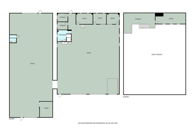 |
||
| Post 4 • IP flag post | ||
|
WGAN Fan CLUB Member Coeur d'Alene, Idaho |
lilnitsch private msg quote post Address this user | |
| @dave3d as for the coordinates if wanting to see the panos on a map or a floor plan they would still need to be built into a tour or viewer of some sort.  |
||
| Post 5 • IP flag post | ||
|
|
dave3d private msg quote post Address this user | |
| Lilnitsch, Don't think tours. In this instance think only how to properly locate 360s on a floor plan of a building. Where the outline of the space of the floor plan is accurate but the internal layout of the floor plan (rooms, halls, offices) is inaccurate. And don't think small space. think 20K plus square feet. With walls and rooms throughout....not open spaces. I'm looking for a simple, fast, efficient way to show where 360s should appear in a large space after the shots have been taken. So whoever is doing the capture doesn't have to draw a "best guess" circle on a floor plan shot by shot. Like, is there a particular viewer that displays 360s by coordinate location? I know with Matterport you have to take one scan to upload. And that Matterport uses a spatial relationship between that first scan and any 360s you do. I haven't used GPS on the Z1s so I'll play with that maybe. Thanks for your thoughts - I didn't think about GPS on the Z1. |
||
| Post 6 • IP flag post | ||
|
WGAN Fan CLUB Member Coeur d'Alene, Idaho |
lilnitsch private msg quote post Address this user | |
| @dave3d To my knowledge I do not know of any viewer that will take photo ordinates and place the images into a floor plan |
||
| Post 7 • IP flag post | ||
 WGAN Forum WGAN ForumFounder and Advisor Atlanta, Georgia |
DanSmigrod private msg quote post Address this user | |
| @dave3d On a recent project shooting 50,000 SQ FT with a 360 camera, I hand-marked the 360s on a paper floor plan of the space. (I numbered each 360 on the paper floor plan.) Does that help? (If I re-shot a 360, I noted that too.) Dan |
||
| Post 8 • IP flag post | ||
 WGAN Fan WGAN FanClub Member Queensland, Australia |
Wingman private msg quote post Address this user | |
| I would use Dan's advise. Just have a floor plan printed and after capture each 360 put a dot on the floor plan where it has been capture. If you need a precise marking for each spot you can carry a laser distance measurement sensor and record a distance for the camera from one or better two walls. If you make the floor plan to known to you scale you can then position each scan from walls with some precision. |
||
| Post 9 • IP flag post | ||
|
|
dave3d private msg quote post Address this user | |
| What Dan said is what we do..... It's just not as accurate as I'd like and if someone else besides the person doing the capture is processing the images they can't confirm locations are accurate. It would be nice to KNOW everything is accurate so someone not scanning can process and be certain they locations are accurate. | ||
| Post 10 • IP flag post | ||
Pages:
1This topic is archived. Start new topic?