


Google Street View connecting floors through elevator (Using Matterport)12604
Pages:
1|
|
Michaela private msg quote post Address this user | |
| Hello, I would like to kindly ask for help with my issue. I have a client that wants me to scan and upload a Virtual tour created with Matterport to Google Street View. The issue is that the clients office is located on 3rd floor of the building, and he wants me also to scan the outer view and parking space near the building. In the entrance of the building is just a long hall with elevator on the other end. It is the only way for me to get to his office. There are no stairs available to scan. Is there any way to fulfill my clients needs? I have never had such request to scan multiple floors that are not connected by stairs. Could this be solved by just scanning his office and then connecting other locations as 360 views? I will be thankful for all and any advice. Thank you very much. |
||
| Post 1 • IP flag post | ||
 WGAN Fan WGAN FanClub Member Queensland, Australia |
Wingman private msg quote post Address this user | |
| You will need some software to get the Matterport tour from Google and back to Google after modification, a 360 camera to capture all missing panos from the ground floor. Then you can use software to build it the way you want. I have done something similar jumping from a ground floor hall near an elevator to a 3rd level hall to connect with a tour for my client shop. I have not used Matterport though but it does not really matter. See it at https://www.wegetaroundnetwork.com/topic/12578/page/1/wayfinding-strategies/#5 Pano2VR can get your tour from Google Maps into a project and then you can add all missing pieces and assign floor numbers to each panorama in your tour. And here is an image that shows the path and linking. The right side is a ground floor path, the left is for the hall on the level 3 and the client shop at the end of the path. I have had to cross it at the last node with the path on the 3rd level because I wanted the arrow that connects the last node on the ground with the fist node on 3rd level to be shown on the elevator. 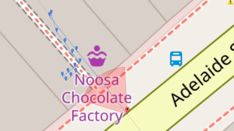 |
||
| Post 2 • IP flag post | ||
|
|
Michaela private msg quote post Address this user | |
| Hi Wingman, thank you very much for the advice ! Thanks a lot |
||
| Post 3 • IP flag post | ||
Pages:
1This topic is archived. Start new topic?