Create a 3D model of a house with this Drone3429
Pages:
1
 WGAN Forum WGAN ForumFounder & WGAN-TV Podcast Host Atlanta, Georgia |
DanSmigrod private msg quote post Address this user | |
| Create a 3D model of a house with this drone http://flip.it/A.eInS | ||
| Post 1 • IP flag post | ||

|
AAS private msg quote post Address this user | |
| Pix2d works with most drones. I definitly dont recommend going with bebop two that type of job. | ||
| Post 2 • IP flag post | ||
|
|
UserName private msg quote post Address this user | |
| Something like that would work great with a Hololens. A home buyer puts the Hololens on, loads the 3D model created by the drone and walks around the house the way they can walk around a Minecraft model. Seems like people with VR headsets with positional tracking could do that too in a VR environment. For these types of "click and view" experiences to become popular over the Internet, I'd think that Internet download speeds need to increase as AR/VR technology improves. A Facebook user today probably doesn't have time to wait for a giant 3D home model to download before viewing it. No problem if the user has Google Fiber, but everyone doesn't have blazing fast Internet connections yet. |
||
| Post 3 • IP flag post | ||
|
|
kevshed private msg quote post Address this user | |
| I think its pretty interesting, but on the whole, i'm not sure the value of a 3D model of the externals of a property are particularly useful for the majority... i could take video and offer something higher quality and an overall better experience. I'm sure in some areas, like construction, or other architectural use cases, could see value - but i think its pretty niche - albeit, pretty cool |
||
| Post 4 • IP flag post | ||
|
|
Ramblinman private msg quote post Address this user | |
| The program is Pix4D. We use it everyday with our drones. But we don't fly a $700 beebop 2, ours is like 50k, specialized for inspections. | ||
| Post 5 • IP flag post | ||
 WGAN Basic WGAN BasicMember Denver |
pixelray private msg quote post Address this user | |
| So Pix4D can be used with any of the phantoms to create exactly what this guy made? | ||
| Post 6 • IP flag post | ||
 WGAN Forum WGAN ForumFounder & WGAN-TV Podcast Host Atlanta, Georgia |
DanSmigrod private msg quote post Address this user | |
| @Ramblinman Can you share a photo of your 50k rig and an example of the work you do? Best, Dan |
||
| Post 7 • IP flag post | ||
 WGAN Basic WGAN BasicMember Denver |
pixelray private msg quote post Address this user | |
| Wow - I am diggin this software. I think this is perfect addition to MP | ||
| Post 8 • IP flag post | ||
|
|
Ramblinman private msg quote post Address this user | |
| @ DAN I can't upload an example because of the file size. So the example is just a screen grab of a point cloud. Building under construction. 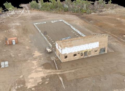 I can also create maps, do volume calculations, 3D Models +++ The second is one of my birds, I've got 3. 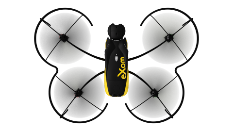 Its so expensive because of the built in safety features like situational awareness, 5 navigational cameras +++. The camera is mounted on the front and can shoot strait up (only current UAV to do so) and down (many UAV's have this feature) @pixelray PIX4D is mind blowing software...and they are working at making it better all the time. The folks that manufacture the drone I have pictured above also have shares in the software company, so things are getting really seamless in terms of work flow. Processing can take time if you've got 1000's of pictures...but I typically have 400-500 photos and processing is 2-3hours depending on what I'm creating. @members If your thinking about adding a drone to your gear, remember that there are rules to follow. I'm in Canada so I have special clearance from Transport Canada and carry 1mil in aviation insurance...+++ so mush more |
||
| Post 9 • IP flag post | ||
 WGAN Basic WGAN BasicMember Denver |
pixelray private msg quote post Address this user | |
| Does the software automatically take the photos once you set the flight path for drone? Or do you have to just constantly snap away? | ||
| Post 10 • IP flag post | ||
|
|
Ramblinman private msg quote post Address this user | |
| @pixelray yes they can be set automatically ...typically I set a flight plan. This would include flight patter, height, distance between photos etc ...in the example above, the flight was pre set and saved because I fly the site once a week. I think about 70 photos in total, about 10min of flight time and roughly 2 hours of processing. | ||
| Post 11 • IP flag post | ||
 WGAN Basic WGAN BasicMember Denver |
pixelray private msg quote post Address this user | |
| Very good. Thanks for sharing. Now, a question you may or may not answer and I understand if you don't...but how much are you charging in addition to your typical drone video / aerial stills for this service? Are people wanting this?? Popular? Thanks again for all the info. Really informative. Ran this by one of my big clients today to see what they thought. | ||
| Post 12 • IP flag post | ||
|
|
Ramblinman private msg quote post Address this user | |
| Price depends on what the client is after. Some are only after 6-12 pictures of a job site every two weeks,..we would charge about a few $100/ visit depending on the job location. Others want 3D models or point clouds to import into BIM software, that can be us in the 10k range over the course of a 10-12mth job...others are looking to get land mapped and surveyed...say 100 acres, depending on job location could run $1800+++ and we typically have to pay a surveyor for 4 or 5 ground Control Points, so that's typically $300-400 we pay out (but the old school way of just a surveyor doing the same job would be $3000 and take weeks to get the deliverable to the client, we do it in a few days)..keep in mind that insurance and equipment is expensive, and running processing software is a skill. I know guys who just process and they charge about $125/hr...Lots of $ upfront, but if you can get the work, alls good....we try and serve one off customers and repeat customers like utility companies and government departments. Lots of public speaking to get the word out, your basically making our own market and educating the public as the tech is fairly new to them...just like MP, you need to show the client the value. .....In the future we hope this is the norm for gathering data...we are basically a "big data" provider...we let the client interpret it, we just gather it. | ||
| Post 13 • IP flag post | ||
Pages:
1This topic is archived. Start new topic?


