


Transcript: iGUIDE PLANIX LiDAR Camera Capture for AEC; DWG Floor Plans19005
Pages:
1
 WGAN Forum WGAN ForumFounder & WGAN-TV Podcast Host Atlanta, Georgia |
DanSmigrod private msg quote post Address this user | |
| Planitar (iGUIDE) is a We Get Around Network Sponsor --- WGAN-TV | iGUIDE PLANIX LiDAR Camera Capture for AEC; DWG Floor Plans with Level of Detail (LOD) 200 | Guest: Planitiar (iGUIDE) Product Marketing Manager Chris White (@Chris_iGUIDE) | Episode: 199 | Thursday, 17 August 2023 | www.GoiGUIDE.com  WGAN-TV Podcast | WGAN Forum Podcast  WGAN-TV Podcast | iGUIDE PLANIX LiDAR Camera Capture for AEC; DWG Floor Plans with Level of Detail (LOD) 200 | Guest: Planitiar (iGUIDE) Product Marketing Manager Chris White (@Chris_iGUIDE) | Episode: 199 | Thursday, 17 August 2023 | www.GoiGUIDE.com WGAN-TV Podcast | iGUIDE PLANIX LiDAR Camera Capture for AEC; DWG Floor Plans with Level of Detail (LOD) 200 | Guest: Planitiar (iGUIDE) Product Marketing Manager Chris White (@Chris_iGUIDE) | Episode: 199 | Thursday, 17 August 2023 | www.GoiGUIDE.com WGAN Forum Podcast | iGUIDE PLANIX LiDAR Camera Capture for AEC; DWG Floor Plans with Level of Detail (LOD) 200 | Guest: [url=https://goiguide.com/]Planitiar (iGUIDE) Product Marketing Manager Chris White (@Chris_iGUIDE) | Episode: 199 | Thursday, 17 August 2023 | www.GoiGUIDE.com WGAN-TV eBook | iGUIDE PLANIX LiDAR Camera Capture for AEC; DWG Floor Plans with Level of Detail (LOD) 200 | Guest: Planitiar (iGUIDE) Product Marketing Manager Chris White (@Chris_iGUIDE) | Episode: 199 | Thursday, 17 August 2023 | www.GoiGUIDE.com  WGAN-TV Training Academy WGAN-TV Training Academy | iGUIDE PLANIX LiDAR Camera Capture for AEC; DWG Floor Plans with Level of Detail (LOD) 200 | Guest: Planitiar (iGUIDE) Product Marketing Manager Chris White (@Chris_iGUIDE) | Episode: 199 | Thursday, 17 August 2023 | www.GoiGUIDE.com WGAN-TV | iGUIDE PLANIX LiDAR Camera Capture for AEC; DWG Floor Plans with Level of Detail (LOD) 200 | Guest: Planitiar (iGUIDE) Product Marketing Manager Chris White (@Chris_iGUIDE) | Episode: 199 | Thursday, 17 August 2023 | www.GoiGUIDE.com WGAN-TV | iGUIDE PLANIX LiDAR Camera Capture for AEC; DWG Floor Plans with Level of Detail (LOD) 200 | Guest: Planitiar (iGUIDE) Product Marketing Manager Chris White (@Chris_iGUIDE) | Episode: 199 | Thursday, 17 August 2023 | www.GoiGUIDE.com Planitar (iGUIDE) is a We Get Around Network Sponsor ---  Image courtesy of iGUIDE for AEC WGAN-TV | iGUIDE PLANIX LiDAR Camera Capture for AEC; DWG Floor Plans with Level of Detail (LOD) 200 | Guest: Planitiar (iGUIDE) Product Marketing Manager Chris White (@Chris_iGUIDE) | Episode: 199 | Thursday, 17 August 2023 | www.GoiGUIDE.com Video: iGUIDE - Architecture, Engineering, & Construction | Video courtesy of iGUIDE YouTube Channel | 26 July 2023 iGUIDE PLANIX Sample 3D Tour and with Interactive Floor Plan courtesy of iGUIDE | 2D Schematic Floor Plans 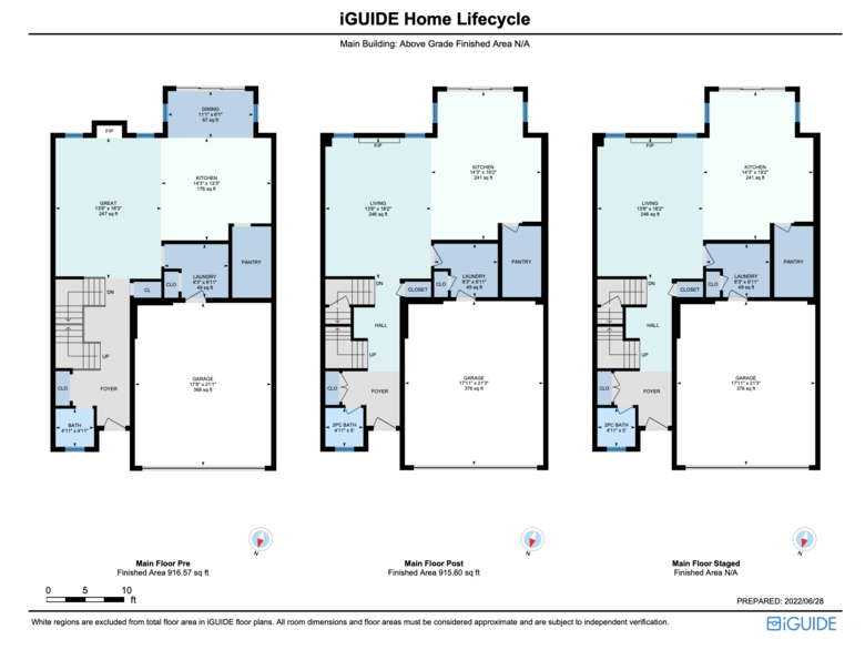 Screen Grab from: iGUIDE Example of AEC Deliverables WGAN-TV Transcript: iGUIDE PLANIX LiDAR Camera Capture for AEC; including DWG Floor Plans with Level of Detail (LOD) 200 Hi All, [Transcript (below) ...] Are you a contractor, architect or engineer seeking faster and better workflows for house remodeling, house additions and the related permit approvals? Are you a real estate photographer that uses - or considering using -- iGUIDE and want to add to your prospect list: Architects, Engineers and Construction (AEC) professions? Stay tuned! My guest on WGAN-TV Live at 5 (5 pm ET) on Thursday, 17 August 2023 is Planitiar (iGUIDE) Product Marketing Manager Chris White (@Chris_iGUIDE): ✓ iGUIDE PLANIX LiDAR Camera Capture for AEC; DWG Floor Plans with Level of Detail (LOD) 200 I will ask Chris to show and tell us about iGUIDE for AEC. As shared in the short iGUIDE marketing video for AEC professionals (above): ✓ iGUIDE eliminates hours of manual measurements and drawing in your construction projects ✓ 1,000's of measurements with each iGUIDE scan ✓ 3D measurements within an iGUIDE 3D tour ✓ Accurate iGUIDE DWG floor plans (Specs) in 48 Hours (instead of 5-10 Days) [Level of Detail (LOD) 200] ✓ Real-Time collaboration and remote bidding ✓ "X-Ray View" for clients [Pre-Drywall and Finished iGUIDE 3D tours) ✓ Saves AEC professionals money and time According to the iGUIDE micro-site for AEC ... In the construction industry, professionals often struggle with inaccurate measurements, time-consuming processes and inefficient project planning and collaboration. iGUIDE addresses these challenges by providing accurate measurements, detailed floor plans, and immersive virtual tours that are developed and delivered quickly, revolutionizing the way construction projects are executed. Discover how you can boost productivity and cut costs with iGUIDE. Source: iGUIDE for AEC ========================== Download iGUIDE AEC Brochure ========================== What iGUIDE meets AEC questions should I ask Chris on WGAN-TV Live at 5? In the mean time: 1. book an iGUIDE demo 2. iGUIDE Contact Us page 3. iGUIDE Contact Us (AEC) page Best, Dan iGUIDE Related Links ✓ iGUIDE Website ✓ iGUIDE micro-site for AEC ✓ Download iGUIDE AEC Brochure ✓ iGUIDE PLANIX Camera ✓ iGUIDE YouTube Chanel ✓ iGUIDE Facebook Page ✓ All WGAN Forum discussions tagged: iGUIDE | iGUIDE PLANIX | iGUIDE Stitch  WGAN-TV Podcast Play List | iGUIDE (WGAN.INFO/search-iGUIDE) |
||
| Post 1 • IP flag post | ||
|
WGAN Forum Founder & WGAN-TV Podcast Host Atlanta, Georgia |
DanSmigrod private msg quote post Address this user | |
| WGAN-TV | iGUIDE PLANIX LiDAR Camera Capture for AEC; DWG Floor Plans with Level of Detail (LOD) 200 | Guest: Planitiar (iGUIDE) Product Marketing Manager Chris White (@Chris_iGUIDE) | Episode: 199 | Thursday, 17 August 2023 | www.GoiGUIDE.com Transcript (below) - Are you a contractor, architect or engineer seeking faster and better workflows for house remodeling, house additions, and the related permit approvals? Are you a real estate photographer that uses or is considering using iGUIDE and wants to add to your prospect list, architects, engineers, and construction professionals? Stay tuned. Hi all, I'm Dan Smigrod, Founder of the [www.WeGetAroundNetworkForum.com]. Today is Thursday, August 17th, 2023, and you're watching WGAN-TV Live at 5. We have an awesome show for you today: iGUIDE, PLANIX LiDAR Camera Capture for AEC, including DWG Floor Plans with Level of Detail 200. Our subject matter expert today is Planitar -- the company behind iGUIDE -- Product Marketing Manager Chris White. Hey Chris, thanks for being back on the show with us. - Thanks for having me. , especially after that whole cat thing. ;-) - Yes. Your cat was a 'guest star' on a previous episode of WGAN-TV Live at 5. Chris, before we jump into today's topic, tell us about iGUIDE. - Right. So if you haven't heard of iGUIDE before, iGUIDE is a technology solution for turning physical spaces into digital ones. It spans a broad range of industries, but essentially, iGUIDE results in accurate floor plans and 3D virtual tours. - And the company was founded in 2013 in Kitchener Ontario, Canada. - That's right, we've been around a while. We actually just had a 10th anniversary sale. - Congratulations. - Yeah. - Let's jump into today's topic. So in the AEC space for contractors, architects, engineers, those that are doing house remodeling or house additions, what kinds of problems or challenges do they face? And let's, for the moment, not talk about iGUIDE, let's talk specifically about problems or challenges that AEC people face every day. - Okay, that's a really great way to start. I think that there are a lot of challenges. I don't know all of them, but I know some of them very well. So, one of the biggest challenges and something that people don't really enjoy doing, I mean, some people do, but not everyone, is measuring homes. So measuring a space can be difficult. And homes are, I shouldn't say homes, buildings or properties are sometimes complicated. So measuring can be very challenging and especially challenging depending on the type of technology that you're using. So, I'm sure a lot of people can identify with measuring something with a tape measure or something like a laser distance measurer. Those things can be great. - Is the challenge with measuring, is it related to how long it takes? Is it the accuracy of measurement? Is it something else? - Yeah, let's dig in. So I think accuracy's a big one, right? Every device used to measure is going to be a little bit different, and they're going to have different levels of accuracy. There’s sag in a tape measure and laser distance measurers are given a very specific error over a certain distance that accuracy has a lot to do with how you use them as well. So are you measuring a single point or multiple points on a wall? It is the frequency that you're using that device. And so that relates to what you just said, which is speed. Yeah, so measuring takes time. It can be very time consuming. - And you also mentioned frequency. Does that mean in terms of, well, it's not just that you measured once, but that you've had to come-back-and-back-and-back-and-back to a space to remeasure for whatever reason. - It could be both, that's really good. So what I was referring to specifically, was non-Standard spaces. So we all assume walls are straight, but that's not the real world. So when you are measuring, you want your measurements to be robust and comprehensive, right? So you wouldn't measure just one point on a wall and go, "Okay, well we're done," right? "That's the length of the room." You would measure multiple points to get enough data to be confident that what you've measured is as accurate as it can be. So, and we're not even talking about really complicated spaces that are round or hexagons. These are square or rectangular rooms. So that's what I was referring to, but that's a really good point in that there is some uncertainty and human error in all forms of measurement, but when you're using a manual method like tape or a trundle wheel or a laser distance measurer, there is that process of taking that measurement and then documenting it. And that can be, like I said, prone to human error. I used to have this problem all the time where I would write down like sevens, nines and I'd get them confused, and later I'd look at my sketches and think, uh oh. I hope I was close. So I was going to say a problem it relates to that process of translation where you're using your device and then you're recording that as well. - Yeah, if we added a human to the process and that makes- - Yeah, humans just ruin things. - Too many errors, yes. Does measurement relate back to the permitting process as well? - It does, yep. So there are specific requirements. If we're going to talk about a problem, then yep, in order to get a permit in a lot of situations, you're going to need certain types of data, floor plans being the one we're probably just going to discuss mostly and elevation diagrams, but, yep. So that's a problem, you need that to get a permit, 100%, yep. - And in the permitting process, does someone have to, the contractor, the architect, have to come back and remeasure sometimes? - In some cases, yes. It depends how the initial measurement was done, but typically there's going to be a requirement. It's different in every area. So if it's not like this in your area, I'm sorry, but there's often a requirement for certain drawings specifically, and then you have to provide those before you can start work. - In terms of the process of, let's take a remodeling, the workflow is, it takes time. Can you elaborate, perhaps, how that might be a challenge in terms of today's existing workflow of doing the design phase of a renovation project? - Oh yeah, so the quality of the data that you are working with, directly affects your design work, obviously. So what I mean by that is you want to have as accurate data as possible when you're doing your design so that they can then eventually become reality more easily. I think the bigger challenge is to go from the bigger problem, I would say, is to go from measurements to something you can start designing with in the shortest period of time possible. So the problem is that, again, the time. - So time and I imagine time probably also equals money, somehow, because generally- - It always does. - Yeah. - It's true. - So, one of the challenges, and it may not be an obvious challenge to someone who's a contractor, an architect, or an engineer because that may be the workflow that they've always done, which is take a bazillion measurements, then go reconstruct the space and then begin the design process. - Oh, 100% yeah, yeah. It's a little different for everyone, but in a nutshell, the traditional workflow is to go to a property, measure it in some way, however that is that you do that, and then you're going to record that somehow. So if you're not using software, you're using a pencil and paper and graph paper, which is fun. And then you're going to take those sketches that you've done and you're going to take them, and then you're going to translate them into some software, AutoCAD, Revit, right up to SketchUp whatever it is that you use, and each one of those steps, requires a certain, there's a cost there in terms of time and literal money. So, yep. - Okay, so I'm going to call that a problem or challenge is the time it takes to go from idea to perhaps construction drawings, or architectural renderings or maybe to say, if you're the homeowner, the first thing you'd probably want to see is some architectural design, so that you can review and approve, but even after it gets reviewed and approved, the next step is to create construction drawings. And so all those different workflows take time. And I imagine there's an opportunity for error in all that, going back to measurements, if you didn't get the measurements right. - Oh, absolutely, yeah yeah. So residential, commercial, either one, there's going to be a point at which you're going to put something before your client, where you want to get their feedback. Stakeholders have to participate in that design process, so the sooner you can get there, the better. But yeah, definitely the time to go from starting the measurements to that consultation part, yeah, that's a challenge, yeah. - And just in general, regulatory issues, because I could imagine that mistakes get made and people -- companies -- get fined. Is that some of the problem? Is that a problem or challenge that, in this space, again, going back to maybe things weren't measured accurately, the way it was constructed. - It could be. I think that's more of an issue during the construction process where if the drawings don't match the reality, that's going to cause issues that then have to be fixed. - Ah, so there may be something to talk about with iGUIDE for AEC that addresses that. Okay. So I think we've talked about some problems and challenges that either are related to time, money, workflow, or maybe even just the ease of doing the workflow. Are there any other problems or challenges, before we talk about how iGUIDE addresses those problems and challenges? - Nope, but I can summarize though. Going to a property and measuring it and then getting it into your software of choice is hard. It just is. It's challenging, it takes time, it costs money, yeah. - Okay, so that kind of leads us into, in this space of contractors, architects, engineers, that are working on house remodeling; house additions. How does iGUIDE solve these problems or challenges? - So glad you asked. So the iGUIDE technology is -- we'll start with measurement, we'll start there. So I used to measure houses for floor plans as a home inspector and energy advisor and a few other things. So, and as a real estate photographer. And when I used to do it manually, it wasn't that I didn't have confidence in myself, it was often that I was in a rush or maybe -- When you're on site, things are different than when you're at home, right? So I would get home and I would maybe doubt myself. So the comprehensiveness or robustness of the measurements was always a question for me. So that's the human error point that we talked about, that's that piece. So with iGUIDE, you don't have to worry about any of that stuff. We have a special camera system and you take it out to a property, and when you scan, you go position-by-position, throughout the space, and it captures thousands of points. So to that point I made earlier about doing one or two points, in a space, well, okay, you've got thousands if you're using a camera with LiDAR equipped, and then all that data independently of me, the human being, is stored, and so I can have the confidence that I've got all the measurements that I need before I leave. - Let me try asking the question a little bit differently, and we'll back in. First, maybe you could tell me what the deliverables are from using an iGUIDE PLANIX LiDAR Camera. We'll talk more about what that camera is and how it works, I'll ask you about that later, but for the moment, let's just assume we did something with this iGUIDE LiDAR PLANIX Camera on site. What are the deliverables? - Gotcha, so the deliverables? - Then we'll map those back to problems and challenges solved. - Certainly. So the deliverables are, depending on what you order, always going to be with some add-ons, a 3D tour or a virtual walkthrough, depending on the industry that you're in. So that's 360 degree visuals. So that comes down to the fact that it has a 360 camera on it. - I'm going to ask you more about each, but let's just- - Okay, I'll just rattle off a list- - Quick summary, and then we'll come back to each of those. - Yeah, virtual walkthrough, floor plans in many different formats, so PDF, SVG, room dimensions, total square footage, and a content delivery platform, which may or may not be useful if you're an AEC, but it's pretty cool anyway. So what makes iGUIDE special, that relates to all those things, is the fact that measurement is part of that iGUIDE every time, all the time, and you never back that out, it's always there. - Okay, so when you mentioned floor plans, is that the DWG or is it that something, in addition to the DWG file? - So by default, you're going to get PDF floor plans. If you want DWG files, you can basically request, and they're an add-on, essentially, and that's what most people in AEC are looking for, and that is the solution to their problem because that's going to go straight into CAD, yeah. - Okay, so for those that haven't seen what an iGUIDE virtual tour looks like, perhaps you could show us. - Yeah, let's do it. - And while Chris is teeing that up, we've done many shows on iGUIDE, and you can see them at: www.WGAN.info/iGUIDEonWGAN So where Chris is talking about an example here, you can see a whole show on this topic, but it's just, maybe you could just tease us a little bit about what we're looking at. - Sure, so you can see my screen, we're good? - Yes. - Excellent [www.GoiGUIDE.com] So this is an iGUIDE, they all look very similar. The core experience is floor plan on the left, 360 degree visuals on the right. The property you're looking at right here is obviously mid-construction. There's no drywall. If I click, I can move forward through this space and I can explore. This is useful for looking at things that may be of interest to you, depending on your industry, AEC in particular. That may mean, well, it could be anything, it could be structure, it could be ducting, it can be electrical wiring. iGUIDE is an exceptional tool for construction progress monitoring. And this example actually has a reconstruction post, which is after the property's been finished, and then even more fun, added bonus, this one's actually been virtually staged, which is pretty cool. So that's not really relevant, but it really does speak to the way this data is used in the lifecycle of a home. So we're living in a world that's really interesting right now. Throughout the entire life of a property, digitization is valuable, before it's built, during the construction, after it's finished, and then when it's literally being lived in, and then even further down the road, this is way off, but when it's being modified. - All right, so let's take a look at iGUIDE. So I noticed that you clicked on the 'hockey puck' down there, so presumably where the camera was, the scan point, you could also go to that map on the left. - You can click on it, that's correct. So the floor plan is- - You could easily go to the great room or the kitchen or the garage or the foyer and immediately go to the space that you're interested in. Then in the top right corner, we're just going to do a brief review of the iGUIDE. - Yeah, let's do it. - Virtual tour experience. There's some links up at the top there. So we're on the 3D tour. - That's correct, yep. So it's more of a marketing piece than anything else because you can include a video and a photo gallery, but there is some value in the sense that we have tagging, real-time tagging, and the images are also available in that gallery. And then the details tab is going to have total square footages and room dimensions, which is a nice touch. - Okay, so if you just go back to that, just for one more second to the details- - Sure. - So as part of the deliverable, and this is still called iGUIDE. - Yeah. - And you can get all these measurements done for you. - That's right, that's exactly right, yeah. - No one came out and physically measured, it's all done through how the iGUIDE camera captures. In fact, take us off sharing if you would, and then I think it's probably helpful just to understand a little bit about the drafters behind the curtain at iGUIDE. - Right. The magic. - Can you speak to that? So let's just assume the contractor's on site, or the photographer's on site, and we'll talk more about that photography process, but they upload a file to iGUIDE, then what happens and how long does that take? - Right, that's a good question. So after the data's captured, it gets sent into Planitar for processing, and what happens, as Dan mentioned, is that drafts people are going to look at that data and they're going to interpret it. And they're going to draw, sketch, if you want to call it that, walls, doors, windows, appliances, a few other things, and they're going to include those details on the floor plans, according to, Standards, and whatever Standard it is that you choose. And then the final output that they make for you depends on what you request, essentially. - So we didn't actually look at a floor plan, per se, we were just looking -- is there a floor plan there you could show us, associated with that? - Oh, absolutely. - I'm sorry to take you in and out of the demo, but I think that was a really important piece. - It's all fair after my cat ruined that other show. It's all good. There we go. So, well, the floor plan you see here, and the actual 3D tour, is an accurate floor plan. So I can actually measure, hope you guys can kind of see this, I can measure directly on that floor plan. As an added note, in terms of measurement, I can measure directly on the images as well. That means I can measure anything in 3D space from this view. So although the main output that we're going to be talking about, probably very shortly, is our DWG floor plans. This is a big deal in terms of giving you the ability to get that comprehensive visual information because you can measure on it. So that means simple questions, like "how long is that short wall?" or "how wide is the window?" or "how long is that cable run?" You can figure those things out right from the- - Okay, I'm going to ask you about the DWG in a second, but I still want to go back to the floor plans because you mentioned a PDF and what's on the left, I don't think of that as a PDF. So download floor plans, you clicked on a button that said PDF. You're then, oh- - Can you see the PDFs right now? - Yes, I can see, I'm looking at iGUIDE Home Lifecycle. So now we're looking at a PDF of the floor plans of the space. - That's right. - And this is all done by the drafters at iGUIDE? - That's correct, you got it. - And it looks like there's some more pages there that I can't see though. - There are, so this is the summary page. So this just shows you the first three floors and then each specific floor will have its own page. So you can see these are all very similar because they're the same house in different parts of the life cycle. - Yes. - It's not that exciting. - And boom, there are those measurements. - And then there's a summary, yeah. - There's a summary, and again, everything that we're looking at here is provided by iGUIDE. This is not the contractor who had to go create this. - Nope, nope, that's the magic of the system. The hard thing about drawing floor plans is drawing floor plans. So we do that for you. - Okay. I'm going to take you out of sharing for a moment, and then I think, really, to get to the crux of iGUIDE for AEC is a DWG. Before you show an example of a DWG file, can you explain why it's important to -- if I'm a real estate photographer and I'm not a contractor, I'm not an architect, what is a DWG file? How is it used, and then maybe, speaking to what problems and challenges a DWG file solves. - Right, so great questions. If we're coming from that perspective where you're a real estate photographer, maybe a lay person, you're not super familiar, I'm not myself as well, I don't use CAD every day, but that may mean that you don't know what we're talking about. So a DWG file is a file format used by AutoCAD and it's compatible with quite a few different things. Revit is another piece of software that's used by architects, engineers, and designers to visualize spaces on their computer by drawing floor plans or creating 3D models that are as accurate as they can get them to be so that they can then do their work, which is take those files and design from them. So if you are thinking about what the whole point of this is, why would even anyone want this? Someone who's an architect, engineer or designer can't get to their work until they get one of these. So they're stuck until they get their drawings and then they can start their work. So if you can provide those for them, you can get them to their work or their value add quicker, than if they were to go out and measure the property for themselves. - Well, let me just see if I can add something here. So it sounds like what the existing workflow is, if you're an architect and you're doing a remodeling for a house, typically that house was not done with CAD files and you can't ask the homeowner, may I have your CAD file? And so the workflow today is that the contractor comes out and takes a bazillion measurements by hand, takes many photographs, and then reconstructs that space in a CAD program, like SketchUp or Revit. - Exactly. - Or AutoCAD, and so there's a lot of make work that sounds like it's happening just to reconstruct what exists. That's not even what the goal is, the goal is to remodel, it's not to create a model of the existing space. So it sounds like if you can get this DWG file and import it into an Autodesk program, like SketchUp or Revit, then you immediately have the magic. - You got it. And so the beauty of this is that it's very tangible and quantifiable. So if it takes me, for example, we'll say eight hours to go out measure and then bring that data back to my office, and then another maybe four to 16 hours, it really depends on a lot of different variables, but a bit more time to draw that property, depending on its complexity, you can cut that down to hours, instead of a multi-day project for this whole process of measuring and then getting the property drawn and into software so you can begin designing. - So in the case of the existing workflow, you might be able to do the existing workflow in 1/10th the time or 1/2 the time, and that probably, as the project gets bigger, the amount of time savings only gets that much bigger. - Well that's right, yeah, absolutely. So it's really hours instead of days. So it can greatly increase the, or decrease rather, the time required to get to that point where you can start actually designing things and drawing things, yeah. - So, and presumably somebody's spending time. So there's a cost or at least a soft cost in 'people time' to design, but even if it was equal, let's just happen to say it costs the same to have iGUIDE create it as to have the contractor create it. If you can do it in 1/10th the time, then you're able to get back to the homeowner with your plan, faster. - That's right, it speeds up the whole process. You got it, yep. - So that probably translates into a happier client. - It does. - And more referrals because the client was blown away by how quickly the architect or the space planner or the general contractor was able to get back to the homeowner with a proposed plan. - I'm generalizing here, but I think most people are happy when things progress quickly, yeah. - And so, and now that you have this DWG file, in fact, this is probably a good point to look at a DWG file as an example because if you're an architect, what this is and what the magic is, but I think about the contractor that worked on remodeling our house and he may not have actually known what a DWG file was. And I think, if you're an architect watching -- if you're a general contractor, or a contractor watching today's show, you may not be the architect or the designer, but if what this DWG file is, then maybe this 'light bulb' goes off in your head. It goes, "Oh my gosh! I can get that file and give it to my architect and the architect can begin the design and I don't have to do all those measurements and I don't have to take all those pictures?!" - Yeah, it's true, it's funny you mention that because if you work with CAD or Revit, you've seen this countless times. If you haven't worked with it, this is mysterious and very strange. As a real estate photographer, I had no experience with any of these things. But the more you work with it, the more you see that this is what people need to get their work started. So what you can see here is I hope this is sort of obvious, but there's door swings, you've got walls, there's room labels, there's, I don't know if, I can zoom in actually, there's- - Yes. - Room dimensioning is the little purple sort of lines. All of this stuff, in this particular file that you see here, is set up in the AIA compatible layers, which I think you did mention earlier. So that means that this is- - The American Institute of Architects Standard layer is part of the deliverable from iGUIDE in this DWG file. - That's right, and this is born from feedback, which is that when, we had another, we have still another version of something similar to an AutoCAD file, it's a DXF file, but the common refrain from people was, "well, we wish it was organized a little better and that the layering was better." So we've done that, we've made it as easy to work with as we possibly can. - And just as a clarification. I'm a photographer. If I went and got my very first DWG file, I couldn't actually open it unless I had Autodesk or some other program, SketchUp, Revit, which it's unlikely that I would have. So, as a photographer or even as a contractor who works with an architect, if you get this file, this is what it looks like, you won't be able to open it because you likely do not have the appropriate program. The architect would go, "Oh! That's exactly what I needed." "Oh! I can begin my work." - Pretty much, yeah. - It's so much faster, you need less of my time. - That's right, exactly. So when people don't work with these, I would usually recommend that they get this software that you see on screen right here. It's [www.WGAN.info/AutodeskDWGTrueView] It's free. You can view any CAD files you want with it. It doesn't allow you to really edit anything that I know of, anyway. At least I don't do any editing. It's really meant for viewing and anyone can use it. If you were going to as say, a real estate photographer or someone who, who isn't using CAD, going to, work with files like these, it's a good idea to look at them from time-to-time just so what you're talking about, With the iGUIDE, it's easy because we give you other floor plans anyway, so if you see the PDF one, what it's pretty much going to look like. - So let's take it off screen share and just maybe talk about this a little bit on this DWG file. You mentioned that it comes in layers. You mentioned that one of the layers is the American Institute of Architects, the Standard layer, this AIA. - Yeah. - What else is included in that DWG file and incidentally, that DWG is short for drawing, DWG, what else is included in that DWG file that is prepared by iGUIDE? - That's a good question. So the DWG file comes to you with an LOD of 200. So LOD is Level Of Development and there's a whole bunch of different levels. There's like 100, 200, 300, 400. So 200 is recognized to be a very usable level. They all have different meanings, which I don't know off the top of my head perfectly, so I'm not going to say anything in case I mess it up. But you can look them up if you want. The LOD 200 is a really good starting point and we had lots of feedback that says that it's great. So there's no question there. We provide, in addition to- - So for example, for a door, you need to know how big the door is, you need to know where the door goes, but you don't need to know its finish and its colors and its materials. So LOD is really sufficient for someone that is going to do a remodel that needs to know where are the windows? Where are the doors? What are the measurements of those that can just be imported into a- - Yep. - Software, like SketchUp, Revit and Autodesk AutoCAD. - You got it. So there are a lot of things included in- - Just to finish that, Autodesk, the company, and their other product, AutoCAD as an example, yeah. So LOD 200, what else that's really significant in there? - So the data's been formatted in such a way, very similar to the AIA layering to be easy to use. So all the wall thicknesses are Standardized to I think half inch intervals and all the room dimensions are, I think, the same, or the quarter inch intervals. But yeah, I don't know if, I think you saw it probably, or it's probably obvious. We dimension the rooms and we added labels as well. So that's kind of nice. - Right. The things - included on the floor plans are, doors, windows, walls, all the things you need to begin that process of drawing that property in Revit- - So does the DWG, maybe I'm going to get a little confused here because I'm thinking about iGUIDE Premium and that's unrelated to the DWG, except you need to buy the iGUIDE and then as an add on, get the DWG file. - Yeah, it's a little confusing, I was wondering if we were going to get to that, yeah. - We'll talk about that in terms of pricing, but if you're going to buy the iGUIDE Premium, then you're going to get labels, areas, objects, dimensions. - That's right. - And the DWG Standard delivery is going to include the dimensions and the labels. - Yes, exactly. So the iGUIDE Premium allows you to get the extra room dimensioning and room labeling. - Okay, so, so far we've talked about deliverables being the virtual tour, the floor plans, that PDF file. We've talked about the deliverable of the DWG file. Are there any other deliverables that one's getting from iGUIDE? - Beyond, okay, well, so what you can order, if you were to order a full package, would be to have the 3D tour, virtual walkthrough, PDF floor plans. There's also SVG floor plans and jfig floor plans, but then if you were to get the DWG and order that all together as a package, you would have all those different sets of floor plans, you'd have room dimensions, total square footages, and then you could do with it, as you will. - Okay, so all the deliverables, got it, now let's see if we can just double check to kind of map that back to the problems solved. - Right. - So do you want to jump in and take that one? We had talked about- - Sure. - Accuracy of measurements. - That's right. Well we can dive into the camera stuff. So problem- - I'm going to come to the iGUIDE PLANIX LiDAR Camera, but if we can just kind of stay, at the moment, on the deliverables as they map- - Yep. - To the problems or challenges. - Drawing a property is hard, so we do it for you. You can take the DWG and bring it right into Revit. Problem solved. It's a head start, so it's not necessarily going to be perfect, but that's because everyone draws properties a little bit differently. So we do the best we can to make it as easy as possible and as compatible as possible with the most people. So there may still be some modifications that you need. Obviously there's going to be differences in different areas or different regions as well. So that might require you to make some modifications, but the goal is to give you a solution to the problem of drawing by giving you the best headstart you could possibly have so that the amount of effort you have to put in at your end is much smaller to then get to the engineering and designing. - Okay. - In terms of the- - So a head start on the renovation process, the design process, a head start for creating architectural floor plans, a head start for construction floor plans, a head start for as-built - Yes. - Drawings, a head start for design, proposed designs to the homeowner, it's just faster. So I presume there's some level of, well, they're going to be more accurate because of how that process took place and maybe some money savings and time savings. - Absolutely, accuracy in the measurement itself, accuracy in the quality of the measurements, and then accuracy in the interpretation as well. So professional drafters who draft thousands of properties are going to be drawing those lines and they're very good, they're very talented people. - So just maybe to overstate the obvious, is all those drawings and all those measurements and all that annotation that we looked at, that's totally done by the iGUIDE drafting team and all you need to do is some process with scanning to create photos and data that gets transmitted to iGUIDE. Maybe that's an appropriate transition to talk about, well, what do you need and what gear do you need to capture and do something on site? Can you talk about that gear and the process? - Okay, that's my favorite part. I've been waiting for this, so that's great. So yeah, so in order to capture the data that's needed by the iGUIDE drafting team, you have to use a special camera system. The iGUIDE camera system is called PLANIX Pro, and it is about yay high. I wish I had one here, I would just show you. But it's got LiDAR built in and it's a 360 degree camera, combined with a LiDAR scanner. So it captures very robust measurement data along with 360 degree images and then those are combined and those are used by the drafts people to draw on top of the data that's collected. So they can do things like identify what is structure and what isn't, and they can draw according to whatever Standards they're using to accurately place windows and doors and add in all the details that you would want in the floor plan. - I'm going to have you pause just for a second, because I want to say that we've done, you and I have done two previous shows, one, which was the introduction to the iGUIDE PLANIX- - I was going to say, we did a iGUIDE PLANIX one. People were going to be upset, yeah. - So it's an entire hour show just on the camera itself and how to use the camera- - I had less gray hair then. You can go see me when I was younger, ? - You can find that at www.WGAN.info/iGUIDEonWGAN And second, you mentioned Standards, and there's some Standards in the space, ANSI, among them, and we did yet a different show, in a deep dive- - Oh yeah, we did, that's right. - Of Standards for those that are interested in that topic. So I'm not going to press you too much, tell us about the iGUIDE PLANIX LiDAR Camera kit because we've done a deep dive on that topic. But once I have this camera and it sits on a tripod, I have a 3,000 square foot space, what's the process like to capture it? How long is it going to take, and how accurate is it? - I know I keep saying this over and over, that's a really, really good question. So a typical workflow in a real estate scenario might be to place the camera in the middle of the room and then, you press a button on your smartphone that controls it and it captures the space. With AEC or creating DWGs, we recommend that you do scan a little bit more. So it takes a little bit longer, but imagine it a bit like this, when you're scanning a space, you're placing the camera in a position where it can obviously see the details that are important, and then you're going to move up a certain distance. So whatever that is depends on the space, but it's not that far. It's maybe like five to 10 feet, something like that. The difference with AEC is that multiple scans per space are recommended because it allows you to use the measurement later. You'll have more data for the drafters to work with. So two or three scans per space is very common. And then we also recommend scanning at thresholds, as well. So that's like, doorways, obviously, and scanning all connecting spaces very thoroughly. It's also very common in AEC to scan exterior spaces, or not spaces, but around the exterior of a property. There's no hard and fast rules for that, but it's very common for people to want to have that data and that visual record of the outside of the property as well. It kind of depends on the project, obviously, but it's very common to scan like the four sorts of corners. - Okay, so if my space is going to be remodeled in the house, I guess for many people that might be the entire house, but let's just say it's 3,000 square feet, how long is that going to take, moving the iGUIDE PLANIX LiDAR Camera on a tripod from space-to-space-to-space to do the level of scanning data that the iGUIDE drafters would like to use? - Good, that's good, so right. So from light to robust capture, like 20 to 30 minutes. And I compare that to manually measuring. So some people are pretty quick when they're manually measuring, so it's kind of hard to, apples-to-apples, but that process would personally take me probably several hours, minimum. - So we have super-fun, on the capture side, you're essentially capturing all the measurements in 20 to 30 minutes for a 3,000 square foot space and then all the time savings associated, and accurate and not transposing errors or whatever it might be. And now you also have the, maybe 1/2 or 1/10th the time to get to the point that an architect can begin actually imagining, re-imagining, renovating a space. - A hundred percent. There's some- - In terms of accuracy, this camera uses LiDAR, whatever that is. How accurate is this LiDAR scan data going to be? - Right, so we can quantify it as a measurement device. It's plus or minus one centimeter at max range. - Okay, I'm in the United States, I understand inches. - Oh, 0.4" ... there you go. - Okay, thank you. - So the accuracy is very good, relatively speaking. - 0.4" over what distance? - Right, so the max distance, which is, off the top of my head, I think 40 meters, which is in imperial 130 feet? - 130 feet, okay. - Yeah. - So if I'm talking about less than a half an inch of variation for something that's 130 feet, if I'm doing a house remodel, I'm going to guess that the capture of the data is good enough to reimagine the space and propose to a homeowner what it's going to look like. It's probably good enough data to estimate materials with subcontractors. - That's right, yeah. And then anyone that's going to come in and actually do an installation of let's say a shower with glass doors, they're going to probably do their own measurements, not rely on the iGUIDE, but it accomplished phase one, phase two with gold stars. - Yeah, yeah, there's always going to be times where people are going to go measure on the ground and get really detailed with it. Actually, there's an interesting quality of life improvement here that we didn't touch on that is hard to quantify, so I'll give you an example. So if I go to a house and it has an area that's circular and then I have to measure that manually, oh, that's rough. With the iGUIDE, it's not an issue at all, right? Because I'm capturing a point cloud using the LiDAR and it's just a circle and then it's interpreted later by the drafters. If I have to measure that by hand, I have to work a lot harder. - Okay, so I heard a lot of geeky speak and if I'm a- - It was a little nerdy. - That probably makes me a little bit angst, but I think it suffice to say you don't really have to understand what the magic of the iGUIDE PLANIX LiDAR Camera does, just that it does it, and then if you're not the architect, you just want to be able to say to your architect, "Hey, I could provide you with a DWG file with an accuracy of 0.4 inches over 130 feet. How's that sound to you?" - Yeah, absolutely- - That's about it. - I'll take it one step further that, across any industry, AEC especially, you don't need to be a measurement expert to use the iGUIDE PLANIX LiDAR Camera or system. If you are, that's great, but you can provide really consistent and accurate results even if you are not a measurement professional. - Okay, so it's not hard, use the iGUIDE PLANIX Camera with the LiDAR. How long does it take to get all this stuff back? I uploaded my file, today is Thursday, it's almost 6 pm Eastern Time. Take me through what's going to happen, when am I going to get my files back? - Yep, so as soon as you submit your data, you're going to get the iGUIDE itself back. So that's the 3D tour and PDF floor plans, the next business day. We always deliver it the next business day. The DWG files take a little bit longer. - I'm sorry, it's 6 pm Eastern Time, Thursday, am I going to get that Friday or Monday? - Friday, yeah yeah, well, so there is one condition, that if you submit it on a Saturday, we don't draft on the Sunday, so you would get it on a Monday. - But today's Thursday and it is after business hours, would I still get it back tomorrow? - You would actually, yeah. So the deadlines are a little confusing, if you submit it before 7 am on the day, you'll get it back that day. So we always say, just to make things simple for people, if you submit it on a Wednesday, you'll get it on Thursday, submit it on a Tuesday, you'll get it on a Wednesday, but actually, if I woke up in the morning and submitted it at 6 am on the Wednesday, I'd still get it on the Wednesday, technically. DWG floor plans, though, take 48 hours, so they take a bit longer. - And does that include the weekends or holidays? - So that includes the, or takes into account that Sunday buffer as well, or that non drafting- - So if I submitted on Friday, I'm not going to get the DWG file back on Monday because you don't count Saturdays and Sundays. - If you did it on Friday, you would get it back Monday, right, 48 hours? - 48 hours, but- - You wouldn't get on Sunday, yes. - Yeah, I'm going to say if you submit it Friday, it's probably going to be Tuesday, because that would be two business days. - Very well could be, but there's good news here though, our times that we give are very conservative. I've noticed this as a company, when looking at competitors, I won't name anybody. - Yeah. - Is that we definitely under-report our times. We're very conservative. So that means that even if you submit and you expect to get it in 48 hours, you may get it way sooner than that. It really depends on- - Yeah, I think the good news here is that what you're really comparing the 48 hours to- - That's right, exactly, yeah. - Is how long it takes an architect to actually reconstruct the space from scratch with hand measurements and photos, which is something presumably no architect on the planet wants to do a design of someone else's work. - Yeah, well, so if you- - They want to reimagine the space. - If you look at capture time and then all the way to deliverables, if it took you from a day to 48 hours onward to get that file that we're comparing it to something that might take weeks, , so- - Yes. - So it's very fast. We've got a lot of feedback and everyone says that it's very, very quick and they're very pleased, so that's great. - Okay, cool. Talk to us about money, okay, so- - Oh, the money, that's the fun part, right? - I'm a contractor, what do I need, what does it cost? - Right, so prices to get to as-built drawings vary wildly across the industry, but they're going to be up in the range of like- - Well first I think I need a camera, so- - That's correct, yeah so- - I go buy an iGUIDE PLANIX Camera Kit. - under $3,000, that's going to include the tripod that you need. And then I go and shoot my 3,000 square feet, I upload this file that contains the photos and the scan data, the spatial data, how much is it to get back whatever it is that I'm going to order? So let's assume that, for that 3,000 square feet, I'm going to order an iGUIDE Premium so that I get the benefit of the annotations with the labels, the areas, the objects, the dimensions that you showed us earlier, and that I also want to order a DWG file. - Okay, so I'll make it. I'll use your example, 3,000 square feet because that's great, but I'm going to make it super simple for everybody. So we have price breaks over 10,000 square feet, and this pricing is all based on square footage, just to get that out there, but just to make it super-duper simple, it's two cents per square foot, or in some cases, three cents per square foot for Premium, for the iGUIDE, and then an additional two cents for the DWG. That means the total cost is going to be four or five cents per square foot, up to 10,000, then it goes down a bit. So we don't need to worry about that, usually. - So what gets two cents a square foot versus three cents a square foot? - Right, good question. So the Standard iGUIDE is two cents a square foot and a Premium iGUIDE is three cents a square foot. - Okay, and I'm just going to say to the audience, if you're doing this and you're in the AEC space, you're going to want the iGUIDE Premium at- - In a lot of cases, yes. We are finding that people do really appreciate the room dimensioning and the labels, yeah. - For 3,000 square feet, fully loaded with an iGUIDE Premium and a DWG file, how much? - $150. You got it. - And you're a Canadian company, is that $150 U.S.? - It is, yeah, that's U.S. pricing, yeah. - And do I need a subscription? - No, there are no subscriptions whatsoever. So with iGUIDE, it's pay per project. That means you pay once and you're done. And if you want, you can actually download all the information and keep it for yourself. So you own it. - And how long is my virtual tour going to work? - So if you download it, it will work for as long as you keep it. We include one year of online hosting, though. So if you do want to keep it online and share it with other people and collaborate in that way, you get one year. - Okay. I want to probe here because the company was founded in 2013 and correct me if I'm wrong, but you've never charged after a year. - Yeah, it's- - So the pricing for online hosting is for a year, but in reality, and the future may not be an indication of the past, but since the company was founded in 2013, you've never charged any additional amount for the continuous hosting of the virtual tour after a year. - That's exactly right, yeah, we have considered it, but it has never been implemented; yeah. - Okay, so no subscription, what about the data, is that data used for anything, is it my data, do I- - It is, yeah. We use it to train our AI models and our drafters, physical drafters, but beyond that, you can take it and you can download it and do whatever you want with it, yep. - So I have the DWG file -- for the virtual tour, is there a player that I get with the tour that enables the playing of the tour? - Yeah, so it's built in. So if you were to download the tour, it's web-based and you can load it into any browser you want, yeah. The DWG files and other deliverables are obviously dependent on the software that you're using to load them, but the tour itself, the virtual walkthrough, you can, yep, just load it in any browser. - Okay. Anything else on pricing or ownership? - It's a great question. So the pricing varies depending on two things, square footage, so this is all you really need to remember, square footage, obviously it's four or five cents per square foot and the package that you choose. And so if you're choosing Standard or Premium, that's going to change the price, and then whether you're adding the DWG, which I think most people who are interested- - Well, in the AEC space, I'm going to say that that's what our WGAN-TV show is about today. So you really are going to want, but to make it super simple, for fully loaded after you've bought the camera and the tripod, it's a nickel a square foot. - Yep, more or less, and you can, yeah- - And if I hit 10,000 square feet on a project, there is a price break. - Yeah, exactly. - Okay, and I think the good news is all your pricing is on your website. - It is, yeah. - www.GoiGUIDE.com and of course, if you want to learn more about iGUIDE, you can book a demo and have a conversation. Just simply go: www.GoiGUIDE.com In fact, if you're interested, particularly in the AEC space at www.GoiGUIDE.com there's a tab at the top for industries, you can select Architecture, Engineering, and Construction . Obviously there are tabs for other industries like residential real estate; real estate photography; facilities management; insurance and restoration; but for today's show, we've been talking about architecture, engineering and construction in house remodeling and house additions. And if you go to that AEC tab, you also can download a very detailed brochure. You can buy the camera at: www.GoiGUIDE.com There's a buy button. Chris, is there anything that we haven't talked about today that I should ask you about? - The one thing that I regret not fully exploring, which will only take about a minute, is real time tagging or tagging. So one of the really interesting things about this whole process is there's all these little features built in that you can, you may or may not know about. So the on-screen measurements I did briefly show, but the real time tagging is quite cool. It means that you can see things in the space and you can tag them while you're capturing the space and then place them in 3D. That was it, so I- - Tag means I can tag that this is a Bosch dishwasher. - Yeah, you can basically, while you're scanning the site, yes, you can identify elements in space and just label them or take photos if you wish, yeah. So for a remodel that might mean, looking at data plates for appliances and furnaces and HVAC and kind of stuff like that. It may mean reading utility meters or something. It could be all sorts of stuff, any reason why you might want to capture data on site, it saves you time because instead of having to get out your camera and snap a photo of the electrical panel, you can just add a tag, place it in the scan on the electrical panel, and then when you look at the tour later, it's just there. So I've found that- - So for clarification, that tag includes the photo you just snapped. - Yes, exactly. If that wasn't clear, yeah. That's why it's relevant. So just having the photo on its own is great, but having the photo placed in 3D space on top of the very thing that you photographed, in great detail, is very handy. - Awesome. Chris, thanks for being on the show again. - Thanks for having me. - We've been visiting with Planitar Product Marketing Manager Chris White. Planitar is the company that provides the iGUIDE camera, the iGUIDE platform. For Chris in Canada, I'm Dan Smigrod, Founder of the We Get Around Network Forum and you've been watching WGAN-TV Live at 5. |
||
| Post 2 • IP flag post | ||
Pages:
1This topic is archived. Start new topic?