


Transcript>WGAN-TV How to Shoot/Create Free InsideMaps 3D Tours with iPhone13734
Pages:
1
 WGAN Forum WGAN ForumFounder & WGAN-TV Podcast Host Atlanta, Georgia |
DanSmigrod private msg quote post Address this user | |
  Illustration courtesy of InsideMaps  Illustration courtesy of InsideMaps InsideMaps 3D Tour courtesy of InsideMaps. (Shot with an iPhone 11) 86-WGAN-TV How to Shoot and Create InsideMaps 3D Tours for Free with an iPhone with InsideMaps Vice President of Strategic Partnerships Gabe Knox (@InsideMaps_Gabe) and InsideMaps Chief Technology Officer Jörgen Birkler Transcript: WGAN-TV How to Shoot and Create Free InsideMaps 3D Tours with an iPhone Hi All, (Transcript below ....) Are you professional real estate photographer that wants to offer virtual tours as an Add On? Are you researching 3D virtual tour platforms that offer a Matterport-like experience without the investment in a proprietary camera and platform and can be shot and produced much faster with an iPhone X or later paired with a $200 rotator? And, a real unlimited free plan with a super-affordable nicely loaded $29 unlimited plan with some optional extras (like floor plans, blue-sky/green grass (and more) image editing and curated snapshots)? Add InsideMaps to your short-list of 3D virtual tour platforms to research and take for a spin. Begin by watching this (above) deep-dive demo and discussion with InsideMaps Vice President of Strategic Partnerships Gabe Knox (@InsideMaps_Gabe) and InsideMaps Chief Technology Officer Jörgen Birkler recorded live on Thursday, 3 December 2020. The show: ✓ WGAN-TV Live at 5: How to Shoot and Create Free InsideMaps 3D Tours with an iPhone Discussion included: 1. Front-End: Demo of InsideMaps 3D tours (shot with iPhones 11/Pro 12, shot with Ricoh Theta Z1); including measurement, photos, video, floor plan 2. Creating InsideMaps 3D Tours using: ► iPhones 12 Pro and iPhone 12 Pro Max (leveraging LiDAR) to create free 3D Tours (beta) [also iPhones X and 11) [InsideMaps is the first virtual tour platform for residential real estate to leverage the LiDAR in the Apple iPhone 12 Pro - paired with a rotator - to enable professionally created 3D Tours.] ► iPhones 10, 11 and 12 to create affordable 3D tours ► Ricoh Theta Z1 3. Image quality and workflow using the InsideMaps HERO Rotator for iPhone + InsideMaps Capture App (Demo with Rotator) 4. InsideMaps 3D tours versus Matterport 3D tours 5. Sweet spots for InsideMaps 3D tours ► Residential Real Estate ► Travel and Hospitality ► Property Management ► Architectural Visualization (including BIM Revit/IFC exporting and interactive interior designs.) 6. Back-End: How to edit an InsideMaps 3D Tour 7. InsideMaps Pricing: (3D Tour, Floor Plan, HDR photos, Video) and photo-realistically rendered walk-throughs for Architectural Visualization ► Beta ► Subscription Packages ► Per Project Pricing (for Cloud-Processed 3D Tours) 8. InsideMaps Pricing: HERO Rotator and accessories (batteries, charger) InsideMaps is a WGAN Gold Member. Happy holidays, Dan 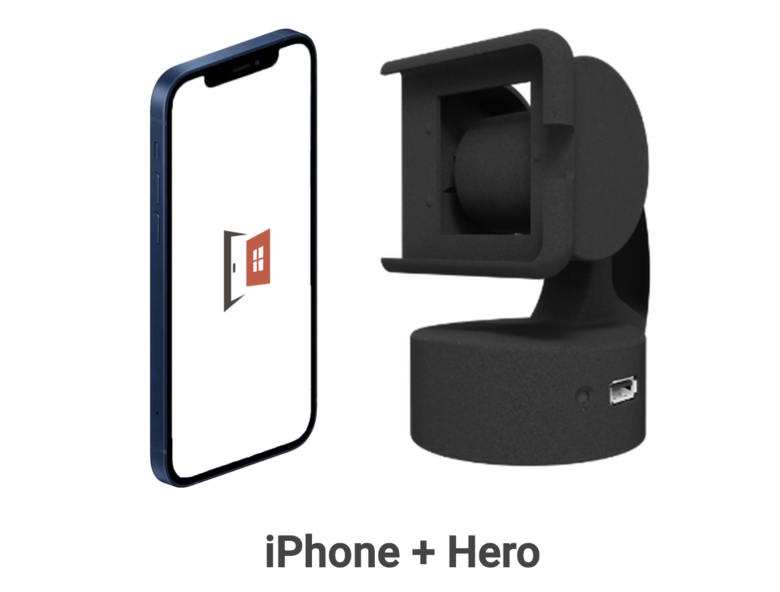 InsideMaps HERO Rotator Transcript (Video Above) - Hi All. I'm Dan Smigrod, Founder of the We Get Around Network Forum. Today is Thursday, December 3, 2020, and you're watching WGAN-TV Live at 5. We have an awesome show for you today, how to shoot and create free InsideMaps 3D tours with an iPhone. And my guests today are InsideMaps' Vice President of Strategic Partnerships, Gabe Knox. Hey, Gabe, good to see you. - Hello, Dan. - And also InsideMaps' Chief Technology Officer, Jörgen Birkler. Jörgen, good to see you again. - Nice to see you again, Dan. Thanks for having us. - You bet, thanks for being on the show. Before we do this deep dive into how to shoot and create free inside 3D tours with an iPhone, I just thought I'd ask the say, hey, InsideMaps has been providing 3D tours, 3D tour tech for years, and I've received my first InsideMaps demo about six years ago from your CEO, George Bolanos, how come nearly all We Get Around Network Forum Community Members have likely not heard of InsideMaps? Gabe. - Sure, well, I'd like to say, even though most of your Forum Members may not be following us, we've been following you, Dan. I really like your Forum and I always look to it to see what's going on in the industry, you do a really great job here. So why haven't most people seen InsideMaps? We've been enterprise-focused, for the past several years, we have been elephant hunting. And what that means is we've been picking specific industries, taking deep dives to understand what they really need and customizing our solutions to meet those needs. A great example of how that's working right now is in the single-family rental industry. So, we are the absolute leader in that space as far as photography and 3D capture technology. And those clients are unique. We're talking about groups that own tens of thousands of homes across the entire United States. They've acquired these portfolios from other aggregators, and a lot of cases, they just don't even know what they own. And each asset is very unique, and so having a technology and a service plan set up, so you can go out and capture that entire portfolio every time someone moves out and every time someone moves in and uses that information to make remote investment decisions as far as whether we should acquire this property or not? What is the scope of work required to get this property ready to maximize its value for a renter? Or, to flip it? And, then getting marketing content needed to do a great job with 3D tours, HDR photos, floor plans, and building data, and deliver that all through API for our enterprise clients to ingest, feed into their ILS, their Internet Listing Service, and then syndicate out to all of their marketing channels is really been our focus, and we've gotten really good at it. Go ahead, you're good? - Gabe, I'm just curious why those enterprise clients ended up choosing InsideMaps, there's literally 170 different 3D, 360 virtual tour platforms at last count? - Certainly, so first the technology has to be affordable, InsideMaps works with an iPhone and rotor that we manufacture right here in Texas. The equipment investment is very low. Next, it has to be easy to use, our clients equip their own workforces to use InsideMaps, or they utilize other third-party service providers, and they have to be able to learn and use this equipment very quickly and be proficient. And next is dependability. You cannot have a wasted truck role in this business. So, when we're talking about, let's say a rental home, if you are delayed one or two days in getting the photos and 3D tour that you need to get that home marketed, that costs our clients $60 a day in holding costs, so we have to be incredibly reliable. And then the other side is just enterprise partnership, being able to assemble all the massive amounts of data that we collect and deliver that to our clients in a way that they can ingest it. And so understanding their back-end and being able to deliver through API so they can use this data efficiently. - So what's changed to make InsideMaps interested in more mainstream customers like professional real estate photographers and 3D tour providers? - Sure, Jörgen, do you want to talk a little bit about what's new with us? You're on mute. - Yeah, so the past year we've been working a lot on our tech and a lot with machine learning. And what we have been able to do now lately is to push some of that technology to the device, to the extent where we have so much technology running on the iPhone that we can produce a 3D tour from the phone itself. So that enables us to offer, I think, offer a really compelling platform for photographers having a future-proof iPhone that they can shoot their 3D tours with. DSLRs, I mean, point and shoot cameras have already been replaced by mobile phones and they are now also replacing DSLRs. With InsideMaps, we believe there is no need, and these other big bulky cameras will be pushed to a niche market. And if you're doing more 3D tours and addressing a bigger market, the iPhone is the way to go. The other thing we have is also identified some features that we think photographers are looking for, like customizing the tours and so on. But also our overall lower cost of both the hardware investment and the cost of processing the tours, I think is compelling for the photographers. And then on top of that, we have some services that we provide for our enterprise customers that we believe can be interesting for photographers. We have blue-sky replacement and fast turn around of floor plans and other services. And of course, another interesting development is the LiDAR now with iPhone 12, which allows us to do a very compelling birds-eye-view of the property using the iPhone 12 Pro LiDAR. - I just got my iPhone 12 Pro, so I'm super-excited to take InsideMaps for a spin and understand how this LiDAR thing fits into real estate photography with InsideMaps. Gabe, how about showing us an InsideMaps 3D tour, if you could from the user's perspective of say someone who's looking to buy a house. - Sure, I'm going to go ahead and share my screen. I apologize if I have an abnormal amount of tabs open, that pretty much describes my life. And so here we go, what you're seeing here is the InsideMaps listing page. So we create this property page for each one of the scans that have been performed, what's really unique about InsideMaps is with one scan and zero touch, this is what can be delivered back to our clients, and it's really all their marketing needs. And so, Dan, you asked why these enterprise clients choose InsideMaps? Well, they want to be able to take a low-skill person, put them in a property for 35 minutes, and that person walks out with a complete package professional, visual assets without any post-production or any work on their side, and that's what we do. And let me show you what it looks like. And so here; the property page customizable to our clients. That happens to be my wife, actually, who has a brokerage here in Texas. We see 3D tours, HDR photos, video, and floor plans. And I'm going to go into each one of these assets individually. First, we'll look at the 3D tour. We'll start from the beginning. So, with InsideMaps, you'll notice that the way a 3D tour can be navigated is with a pointer, using spin stations, just by clicking on circles that are in the tour, or they can click on the red dots, which are in the floor plan. And so if you see on the top left here, this is a mini-map of the home, and each one of these red dots represents where a spin was taken. And you'll notice that the density of the spin stations is probably a lot less than what you're used to with a 360 camera. InsideMaps doesn't need to scan every 10 feet. Really, we just instruct our photographers to scan two scans in each room, one scan from the center because it's the best place to observe the room and another scan from a corner that has the best angle for a photograph, basically the place where you're going to see the most stuff. So if I was going to take a still photo of this kitchen, this angle is much better than if I was right in the center of the kitchen trying to take pictures of the cabinets closeup. You'll notice InsideMaps works very nice, inside and out, including being in the sun. And then you can toggle between floors up and down. So what'd you notice with InsideMaps is you get a high quality 3D tour and we feel that's important. There's a certain standard that needs to be met for 3D tours for our customers. And we noticed that some tours that are captured with the 360 camera, you just can't get the resolution that is required for a high quality 3D tour, and InsideMaps is able to achieve that with our iPhone, and Jörgen will talk about that a little bit later. Next, HDR photos. So from the 3D tour, we can capture high quality HDR images. We have this tool for both the photographer or customer to capture their own images, but we also procure the images for our clients. And so if you choose a package that has procured images, we can deliver this package of 25 still photos or 15, whatever you require to you, the customer. - So Gabe, for clarification, does that mean InsideMaps does the selection for you? - Exactly, one of our trained operators will go through the home and select the best photos and capture them and deliver them in the listing page or API for enterprise customers - I'm probably getting a little ahead of myself, but does the photographer have the option of choosing the pictures themselves? - Certainly. - Okay. - Next, we'll look at the floor plans. So InsideMaps floor plans, you'll notice that they have furniture in them. And what I mean by that is they have the toilets, they have the sinks, the cabinets, the names of the rooms. You can see where the windows are, where the doors are. This isn't just a floor plan, these are actually 3D models that are collapsed to the 2D representation of the floor plan. These models are semantic, everything that you see here has attributes to them. The doors are doors, windows are windows. The names of the rooms are generated by the scanner, they can be edited after the scan. InsideMaps is really smart, but we're not smart enough to know the difference between a family room, a living room, and a den. And so we rely on our photographers to name those rooms. But if a room has a door and wasn't named, we infer that that's a closet. Okay. You'll notice here that we also have... - I see an account of square footage on here? - Yes. And so InsideMaps is very good at capturing the square footage of the home. We decoded the logic of GLA, Gross Livable Area, understanding spaces and rooms have certain attributes like a garage is a non-livable space, it would not be counted towards the Gross Livable Area of the home. Understanding void spaces, like when we think about the foyer on the second floor, right? This particular house has a chandelier that comes down from the front door. This space would not be considered a livable area in the floor planner in our totals, but it's still shown on the floor plan. And so we've decoded all of that logic to be able to deliver a very accurate GLA for our customers. Going back to the listing page, we also can capture videos from the 3D tour. I call these... Go ahead. - Excuse me, I know you're about to play a video, and I just want to let our viewers know that frequently when we play videos through all the technology that we're doing to run WGAN-TV Live at 5, the video, which is probably silky-smooth on your end can be a little bit herky jerky on our show, so it's not a reflection of InsideMaps video that's a reflection of our technology used to do the show. - Yes. Thank you, Dan. So yes, this video does play very smooth. And so we call these turbo tours, we liked them because they're fast, we try to keep them under a minute. They're very relevant, they get to the most important parts of the home. They are definitely not a slide show, the viewer gets the experience of walking through the home because they are captured from the 3D tour. Everything is in HDR, so we're not getting the issues like with typical video of poor lighting or the windows just blowing out the rest of the room because it's a video and you're changing the lighting environments. They're also no, "Blair Witch Project," effect here of the shakes that you may get through a normal video. It just gives you what you really want to see. We also liked these because our clients can download them in an MP4, which gives our customers a lot more options in how to share this content. They can put it into their social media, on their YouTube page. It isn't content that has to be hosted like a 3D tour on our website. - When you began, I guess I would call that a single property website or a property website. Is that offered both in a branded and unbranded version, unbranded version for MLS? - Yes, exactly, and so if you see like our share button here, you can copy and paste the branded link or the unbranded link. And when we say branded, really, we mean taking the REALTORS' brand off of the content or not, but being able to brand these edit and brand right to your customers is a feature that our photographers really like and so does their customers. - I see a location button, was there a map in this as well? - Yes, there is. There's just a widget here with the map of where the property is. - Okay. Is there anything else that you wanted to show on the front-end? - That's our core deliverable. - Okay, so maybe you or Jörgen can show us a little bit about the capture process of how this tour was created. - Yes. Sure. So let me introduce you to our HERO as we call it, our rotator. It hosts your iPhone. So you slide your iPhone into the HERO it has a rechargeable battery that runs the two motors and the phone connects to the HERO using Bluetooth. I will show you a quick demo, how it looks when it's turning around. - Okay, Jörgen, it's a little bit off camera, if you could just maybe bring the, yep, that'd be great, thank you. - Yeah. - Even before you just take one more word, I have to say because I obviously have one too that you sent me, $1,000 plus iPhone, I just want to let you know that I felt like, okay, how am I going to feel when I put that phone in there and am I going to lose it? And I felt like when it felt really secure, it fit tight. And I didn't feel like there's a risk that when this thing's rotating around that I'm going to lose my iPhone on a stone floor. So I just thought it was very well constructed and snapped in place. - Yeah, it's one of the things we've been working on, making sure the motors are working, and making it really robust. There's practical things too like you can charge your phone from the HERO while you're scanning, so that you can keep your phone up-to-date, so you're not losing too much juice on your phone. Well, yeah, the app that we have, it controls the HERO using Bluetooth, while it's doing that, it's taking the pictures. So we're of course using the very good camera from Apple, taking advantage of whatever thing they have done for the cameras. We're really standing on a giant here, all the noise reduction and auto-focused and things that they're doing with their cameras, color processing and so on. So, that's the practical thing. - Let me just jump in here, I feel like this is something that we should talk about what the user experiences with this motor. So you see how it spins around, and one of the nice things about a camera that spins around is you can walk around with it. You don't have to run away from the camera, hide, take a picture and then run back. And so the time that it takes for that phone to spin around, you really don't feel it as much because you're not having to leave the room and come back. You just simply walk around behind it. Good, Jörgen, sorry to interrupt. - No problem. So I'm going to try to share now how it looks from the app point of view when you're scanning. So I hope you can see my screen now. - [Dan] Yes. - This is a screen grab from, I did just a short scan to demonstrate some of the features that we have in the app to speed up the scanning procedures. So here's the scan I did of the living room, and it shows the panel that was processed on device. What you see here is what our machine learning sees. So you can see a number of things here, including that they detected a few of the doors and that's key then to make sure that we can scan in a really efficient way. This is like somewhat of a glimpse behind the scenes of what the app is actually seeing from the scanned data. And what you do with the app is that you tell it somewhat where you're going, at least approximately where you're going, and then you're adding new spins to the procedures. In this case, I'm adding an office here to the already scanned positions. This is an interesting learning experience from us. We ask if the lens is clean, it's something that happens with our iPhones, but it's things that were figured out using the iPhones, but you probably in some cases need to clean your lens. So let me go back here. Yeah, so here it shows you where you're placing to try and put from what position you told the apps. This is just to verify that you're putting the tripod in approximately the position where you told the app to position, Actually, it's going to align the spin here with the rest of the spins. So it processed the pano, and it also figured out the structure of that office that we just added. And you can click then and go into, and look at this office. And here's then, you can see the previous count position here, and you can like test the drive the tour already on the device. So here the app actually then connected the rooms, not using line-of-sight, but actually using the doors that were shared between these two rooms. Yeah, another thing we have in the app is that you can look at this information in different ways. If we scroll back a little bit, I can highlight that these circles you see on the screen are recommendations that the machine learning engine has detected our good scan positions to continue. So all these green fans you see are doors that have been detected. So the app is helping you to guide you through the scanning procedure. And there's help, how close you should space the spins. If there are occluded walls, it's going to help you on that. - In that menu, on the top right that has five or six different options while scanning, why would you choose one versus the other options and then why would you pick one versus the other while you're spinning? - Yeah. So the color shows the type of rooms. So this can be good to make sure you identify the rooms correctly and choose the correct type like bedrooms and kitchens and so on, so it gives the color coded version of the rooms. The outline is just showing the different rooms. - I'm sorry, you're going a little bit fast for me. So I'm going to say the reason it knows that it's a bedroom - as the photographer - I've actually told - when it's asked me - what kind of room is this? I've said it's a bedroom. - Correct, that's correct. - When you're color coding, it's not that it figured out that it was a bedroom. I actually identified as a photographer. That's a bedroom that I'm about to do with 360. - Correct, but you can self-test yourself. You'd be surprised how many times we get scans for everything, it's an office in the whole scan. The outline shows the wall, so you can get a rough floor plan view of all the things. This one it's called covis, it's a short for co-visibility. So what you can see here is how machine learning has connected these two rooms. So there's not the straight connection between those two spins, but actually through a door in this case. And yeah, that's actually the last one I have on the video. So the last one shows a textured mesh instead of the point cloud actually, the mesh that you would expect. - I guess I should point out for the purpose of show and tell today, you're actually doing this off of the video, but this is kind of a simulation of what a photographer would see while scanning, and then have a choice of whether to look at it as all solid, or mesh, or outline view, et cetera. - That's correct. So if we look at that tour that I just grabbed, this is how it would look then with the connection through the door, so instead of having a connection through to spin, it's actually going to go through the door. So you would click on the door to go to the living room. And this is one of the key things we have done is really to make the scanning experience really fast, to more or less be able to capture a whole house using one spin per room, maybe two for the larger rooms. We don't put a limit really on the number of spins, you can put as many spins as you want to make a really smooth or many different vantage points. But for certain customers, you can really get in and out of the property really fast. - Jörgen, we could just go back for a second where you were showing that door. And again, for clarification where perhaps with another platform, I might shoot in the middle of the room, shoot at the doorway and then shoot at the middle of the other room. If I hearing you correctly, what you've done is to say, no, no, you could really just do the shot in the middle of this room, the middle of the next room, but the locator for showing the next scan is not going to show up where the thinness, it's going to show up where the doorway is. - Correct. - Essentially, I'm going to select the doorway to go into the next room, but I'll actually land on the 360 in the middle of the room. - Yeah, so you don't have to put the spin, within some apps, you don't have to put the spin every six feet or in the doorway. So you can make a tour that is connected through the doors without actually having to put the spin there. But if you want the spin in the door to make the transition even smoother than you can, we gave you more options, so to say. - Okay, so if I want to be able to shoot a 2,500, 3,500 square foot house even faster, I don't have to have line of sight, I literally can just put the scan in the middle of the room of each room and that'll be fine, and then if I'm using the tour for the purpose of HDR photography, then I'll put the camera in one of the corners of the room for that purpose. - That's correct. - Okay, is that 360 that I take in the corner of the room going to show up in the tour is an option for someone to stand there as well, or is that just used for the HDR photos? - So once you have done the tour, it will be shown in the tour, but we do have the option of hiding spins in the tour as a photographer, you can go in and hide individual spins. So it's up to you if you want to customize that and hide those spins later. - Okay, in this mode, can you also look at the dollhouse view? - Yes, this is done using machine learning, so this is not LiDAR. So this is more of a rectified dollhouse view of this thing that was processed on the iPhone and that same information is used to, yeah, you would see a cursor here to follow the walls and also used to create the transitions between the rooms and within rooms if you have multiple scans in the same room. - I'd like to add, well, Jörgen has shown us a lot of the behind the scenes and the different functions of how the machine works. Most of our customers are not sophisticated photographers, photographers, I think are such a unique balance of an artist and a technician. They have to handle really tricky equipment sometimes. Most of our customers are thinking more like an inspector, which might be a non-digital native who at first rejects technology altogether. And they have to be able to pick InsideMaps up and very quickly learn it and go through a home and be successful with complete consistency. And that's the real feel that you have for this app. It is super-fast and really easy to use and very difficult to make mistakes or get lost in. And so basically, I say that your first home you're figuring it out, the second one, you're a little awkward. And by the time you've scanned your third home, your rate just trains a workforce and replicates yourself. - Okay, cool. Gabe, can you show us the back-end, the content management system as a photographer? Jörgen mentioned that I could hide a scan for example ... where I pick out the HDR pictures, et cetera, is that something you could show us? - Sure, sharing my screen back with you. Okay, back to our same project here, we can go into the edit listing mode and everything that you see in this listing page, you can edit, so I can click on the agent information. And right now, we see this as branded to the agent. You can brand this for your own photography company if that's the brand that you want to put forward, same thing with changing the address or even the title of the project from the 3D tour, just hitting our edit button. We can go into the 3D tour tools. I can set a new starting point for the 3D tour. I can set a floor start point, I can even change the splash screen for that should be. Okay, going back from that. I can also edit my HDR photos. So going to my photo capture tool. - With these pictures that are here, these images, were these, let's say that procurement process you were describing, they were automatically selected by InsideMaps, and that was the default as the tour was delivered? - Actually, I selected those ones. But, if you choose the auto procure photos, you'll just pick a package of how many photos you want and our team will select those for you. And then as the photographer, you still have the ability to come in and capture additional photos and, or even delete ones that you don't like. - Okay, so you're showing us how to actually take a photo or a snapshot within the tour itself. - Exactly, exactly, so from right here, I could say, this is the photo that I want to take and just click and boom. And now, that'll be added to your carousel on the bottom, see where the photo is, it's uploading and on the bottom. And so now, that's a photo that will be in a carousel that you can deliver to your client. All right, and then in your edit mode, you can also reorganize your photos to see how you can change around which photo you want to see first or last. - And I imagine this is a little bit snappier when you're not tying up your wifi doing WGAN-TV Live at 5. - Yeah, and, or under pressure. But yeah, by the way, this is a heavy tool. I mean, these are high quality images that you're moving around. And so, it works really well. And yeah, it is slowed just a bit over our video conference. And then you can save that. - Do you have a choice of files of image size? - Yes, you can change the image sizes when you capture them with your aspect ratio. And then when you can download these, and so you see a download all or download all, no watermark for your branded and unbranded. This is really important for our property management customers. There's a lot of scams out there, where they'll take a rental property photo and put a Craigslist listing and start collecting deposits for that property. And so our property management groups want to watermark all of their photos and then have the option of having non-watermark photos if they do wish to list on MLS. And it's really great, this is like an org setting, once you have uploaded a watermark, it'll stay with all of your photos and any customers that you put in that organization. And you can even watermark it for your own photography company if that's what you'd like to do. - Okay, is the video automatically generated or is that something you order? - You order it from us. And so you'd say, "We'd like a video," and InsideMaps makes that video for you. We do that because the tool itself to make the videos, it can be a little bit tricky and we just want to control our customer experience down the line. We may want to open that tool up to the photographer, excuse me, photographers because I think they would be comfortable using that tool. But for the everyday user, we don't want to confuse them with that much technology right now. - Okay, on those floor plans, I have a choice of metric US inches and feet fitting. - Yep, can change it from metric, US. You can change the fonts, you can change the labels. If you would like to hide the room dimensions, and you just wanted to show the names of the rooms and not rep to the measurements, you could certainly do that as well. - So do I have control over renaming a room? - Yes, you do. And so just from that room itself, you can click on the room attribute and then rename it. And you can even do where that label actually exists in that floor plan, and so you can drag it. - And so I imagine I could add a logo to this if I wanted, if I had a different disclaimer text I wanted to add, I could select, can I select a color palette for the agent, the brokerage? - For the logo, everything in the floor plan is black and white right now. - [Dan] Okay. - All right. - Anything else to show on the floor plan? - Nope, that's most of the floor plan tools right now, and I'm trying to figure out how to escape out of this and not my Zoom because my Zoom is good. - [Dan] Yes, Gabe. Thank you. - Great, all right. - Okay, how was the address set for the map? - Through geolocation. - Lemme ask it a little differently, so it was a photographer when you begin creating a tour, I imagine you add an address for that property and that address is carried through to Google Maps. And so if I put the correct address in, when I begin creating my tour, then that map is going to end up being correct. - Exactly - Actually, yeah, that turns on GEO location when you're scanning, so you don't even have to enter the address in most cases. - And I have an option to override that... - You do, yeah. - ...in the InsideMaps Content Management System. Okay, cool. - Exactly, so sometimes the first scan is in the middle of the road and you don't know if that's the property behind you or in front. And so yeah, you do want to check that address and make sure. And if you edit it, it'll carry through to the type project. - Okay, was there anything else on the back-end that you wanted to show us? - I think that's good for the video now, but I can tell you that we have a full, what looks like a CRM view that if you're an enterprise user, you can have organizations and sub-organizations and view all of your projects. And I can actually give you a little glimpse into that right now. - Okay, so as a photographer, I have multiple clients, so I have a way to keep a logo for one particular agent a logo, a photo, et cetera, for one agent, so I can quickly apply it going forward to her tours versus... - Exactly, and I can show you what that looks like here. Let me make sure I'm sharing my screen back to you. - So Jörgen, it looks like there's a lot of magic that's going on behind the scenes to make all this happen, so congratulations, this is really, I imagine it's hard work to make it look so easy of how you're doing that back end to assemble all these 360s that are getting captured. - Yeah, there's a lot of stuff that we have been doing. - Okay, Dan, are you seeing my InsideMaps homepage? - Yes. - And so if I'm logged in to InsideMaps, I can look at my organizations and see all the different organizations that I have. Okay, I can go and look at... - So an organization might be, it's this brokerage, it's that brokerage, it's that agent, it's that client? - Exactly, exactly. Or it's this client in Atlanta and this client in Dallas, right? And so each one of those organizations can have their own rules and standards for how the floor plan should be formatted or what the logos are. And then you can see all of your projects in a thumbnail or lists and search for individual projects, check the status, update the permissions. - Okay. Other things to show us on the back-end? - Not that I think the user group will find it very interesting on this call, but we can have it in trying breakout. - Fair enough. You were showing us this with the, an iPhone is the creation tool. Can you use a Ricoh Theta Z1 and Insta360 One X2, any other 360 cameras? - Yes. - So we support 360 cameras. So right now, we support the Theta cameras. We're using the open spherical API to grab the picture. So we might expand it, but we have tested, and we are officially supporting a Ricoh Theta Z1 and a Ricoh Theta V. - V as in Victor, yeah? - Yeah, we support that one. And also SC I believe. - Okay. - So that's a part of the cloud processing, we offer it out. - Okay, at the present time, not the Insta360 line of cameras. - We officially don't support it, it might still work since they're probably using the same protocol, but we officially don't support it yet, we haven't tested with that camera yet. - Okay, I just like to weigh in a little bit with a kind of an editorial opinion here because I think is probably going to fall into two camps. There's going to be photographers that say, "Hey, I have a Ricoh Theta Z1, that's what I want to shoot. Why would I want to shoot with an iPhone?" And I guess I should probably turn this back to you. But I certainly, my impression is if you're rotating an iPhone and taking whatever it was 16 or 18 pictures, the quality of the photography is actually going to be exceptional. - Yeah, so I mean, first of all, the camera on the iPhone is very, very good now, it has three lenses on the new phones, and it has a lot of magic that Apple is adding to it. There is noise reduction, there is all this optical stabilization and auto-focus, and of course we stand on top of that, and we add our own magic to that. And one of the things we do is of course, to create the 360 from all these pictures that we take. And actually, it's taking more than the things that you see because each time the HERO stops, we take multiple exposures, normally exposed and overexposed. And we use those images to create the final 360. There is also an overlap between them, and just so when we're choosing a pixel for the output, there's actually more than 12 pictures to take from the raw data so to say. So we use that to pick the best color from those, but also to even reduce the noise even more in that we can see the same information, the same sport in the real world we see from multiple pictures. Yeah, and then we add our own magic, which includes this, getting the best colors from the images. We also do some optical flow stitching to really bring the images together without too many stitching artifacts. So there's a combination of picking the stitch point, so where the crossover happens, so that happens in less obvious areas if we need to. And then we also have the flows, which tries to minimize the stitching errors. We have a choice to when scanning what resolution you have, so you can actually go up to 8K and what that means, it's the final output has six cube sites with 8k times 8K, so that's more than 300 megapixel. It's a bit heavy-weight to do that, but you have the option to go up really high. The regular resolution is around 25 megapixels when delivered in the final content. There are intermediate representations to which we use when we do photo capture. So if you do a photo capture behind the scenes, we're using a little bit higher resolution too. - Yeah. - Yeah, so to answer the question, like, why should you use the iPhone? We have, I think, much higher quality, less noise, so you get better pictures. And we also feel that the whole platform relying on the iPhone, it's a more future proof thing. You can quickly switch your iPhone. And historically, it's taken us only one week or two to support the new iPhone, and actually produce a new holder for those iPhones. So when you're switching to iPhone, you can rely on having InsideMaps support for those new great cameras. - I want to speak to the We Get Around Network Forum Community specifically on this point because there's probably two camps. One is using a Ricoh Theta Z1. Your workflow is probably going to be faster, you can zoom in, take that shot, pick up and move. On the other hand, if you're using an iPhone with this rotation and everything Jörgen has described, your image quality is actually going to be phenomenal. And I think if you put the image quality side-by-side, and maybe Gabe, you could work on coming up with, this is a Ricoh Theta Z1, this is a iPhone 12 Pro side-by-side: same location to be able to see the difference, I think that would be actually tremendously helpful for our Community if that's possible. Because I think sometimes we get fixated on gear and we say, "No, I have a Ricoh Theta Z1. I bought it to shoot 360s, I'm going to shoot it to use InsideMaps." And certainly you can, but just pause for a moment because even though this rotator, this InsideMaps HERO rotator, it's not a big clunky camera, just the simple thing that kind of rotates, it's going to end up producing a phenomenal image quality. And I think just to take that pause for a moment and say, if image quality is something that's really important to you, your workflow may be a little bit slower, but you'll end up with phenomenal 360s. And then I imagine Jörgen and Gabe; photographers if they want to edit their 360s, and load them back up into the platform, that's an option? - Yeah, that's something we are supporting our customers today. So we're also planning to offer it up for this type of projects, marketing projects, they're able to edit and we have heard that that's something that they want to do. There will be some restrictions, they need to keep the same file name and they can rotate things around because otherwise things will be weird. Another thing I want to highlight though, in the scanning, even though you're scanning with a Theta, there's still time where you're running inside and outside of the rooms, you still need to hide. So yeah, it might be a little bit slower, but it's not super-dramatic. - Yeah. - Another reason I just want to mention too, we didn't get the chance there. The new iPhone with the LiDAR is also another reason to go with an iPhone. And if you allow me to share the screen here, I can show you what we have been able to do with the LiDAR, which... - That would be great. While you're setting up, Jörgen, I just want to mention one of those things that's just so amazing is by building your platform around an iPhone, I don't know about other photographers, but every year, I upgrade to the next phone. So that means when you get your next phone, you essentially are updating your camera that you're using for InsideMaps. And you're not buying a separate camera and making it, it's just, no, you update your phone every year or every two years, and that means you're getting the benefit of whatever improvements come to the iPhone are ending up paired with InsideMaps. So I have this very big bulky camera and it's used for one thing, and I don't really have a reason to update it. But if I do, it's totally separate from my iPhone. So then I got two devices to update. No, no, I just naturally update my iPhone every year. And so I get the benefit of that with InsideMaps. - Yeah, I think that's a very good point. (Continued...) |
||
| Post 1 • IP flag post | ||
|
WGAN Forum Founder & WGAN-TV Podcast Host Atlanta, Georgia |
DanSmigrod private msg quote post Address this user | |
| (Continued...) --- - iPhone 12 Pro Max LiDAR. - Yeah, so this is iPhone 12 Pro, this was shot with an iPhone 12 Pro. So I hope you can see my screen, is that correct? - Yes. - Yeah, so this just works like a regular tour. You can move around, the main difference is some subtleties and it is we have this birds-eye-view now that have more details to it than if you shoot without the LiDAR. So you now, you can actually start to see the sofas and things like that to turn around. So this offers this overview that is important to certain photographers. It also allows a little bit higher quality and doing transitions. We're able to use all the geometry to re-project the panos when we're moving them around. The shooting procedure is the same. So here, there are generous amounts of spins, but you can also shoot with less spins than the other, like the regular tours. And this will also be part of the same offering elsewhere, offering for the, as the other packages to fit like... - Jörgen, I'm confused. So first on the good news, what you're showing is phenomenal. So you're showing the 3D dollhouse, so for photographers where that matters, that kind of checks the box to say, if that's important to you, you can have a dollhouse. The next was when you were transitioning from as you were walking through the space, it was not as if you were going from a 360 fade-out, fade-in to a 360. You were moving through the space without any fade-in, fade-out. So I imagine that's taking advantage of the scan data from the LiDAR. - [Jörgen] Yeah, that's correct. - Awesome, do I need to shoot differently because I'm now using the LiDAR feature rather than what Gabe was describing earlier of taking a 360 spin at the center of each room? - No, so can you use the same scanning procedure, but I mean, as always, if you have more spins, the tour might be more complete. But you have the option to do a very quick scan of appropriately and you have the option of going all out and doing every two meters if you want that, but yeah, the option to scan really quickly, it's still there with the LiDAR. - Every six feet or so. So if in that first example that we were looking at earlier with Gabe, where there was a 360 in the middle of, let's say the bedroom, and then there was 360 in the midst of the next bedroom. And we transitioned from bedroom one to bedroom two by walking through the door, and you knew where to place the marker to indicate here's where you can walk to get to the next shot. If I was to do that with the LiDAR, would I still go through the door or am I literally going to transition through the wall? - So, I mean, it depends on how many scans you do. So in this case... - If I shot it just with the two when a 360 in the middle of each bedroom and the bedrooms were connected, if I just did that, I would literally be transitioning right through the wall. - Yeah, you would be going through the door so to say, that's correct, but if you put more spins, you can go through the space. - Okay. So for those photographers, and certainly We Get Around Network Forum Community somewhat heavy on our roots go back to the beginning of Matterport. So there are many Matterport photographers in our Community. So for those that are real estate photographers that are just researching virtual tours and Matterport, perhaps looking at an alternative, I think what I'm seeing in this demo that you're doing, Jörgen, is you can have that Matterport-like experience by just scanning every six feet or so. And then literally you could walk through the door to the room and there's no fade-in, fade-out. You're taking complete advantage of that LiDAR data that the iPhone can portray - Yeah, correct. - Yeah, I think that's a good summary. We offered, we call it birds-eye-view so you can get this overview. And then we also use the 3D data to make the transitions even smoother when you're walking through the home. So some photographers and customers are looking for that. So we're hoping to shortly offer it out to a wider audience as part of this initiative for real estate photographers. - I'm sorry, I didn't understand, could you remake that point? - No, we're happy to offer this to the real estate photographers. They don't need a bulky camera, they can create these high resolution tours using the iPhone 12 Pro. - Okay, well, if it's so easy to use the iPhone in the InsideMaps HERO, why not market InsideMaps directly to real estate agents? Why are you interested in our Community of real estate photographers that do virtual tours, Gabe? - Yeah, I can take that. That's a really interesting question. So early on, we, first off, let me reiterate, I am a real estate agent. My wife and I have a pretty large brokerage. We're part one of the largest brokerage networks in the country, and early on with InsideMaps, we actually struck a deal with one of the largest real estate offices. I'm talking about one single office that has over 600 agents working out of that office. And we worked a deal with the owner of that office, that InsideMaps will be free to any agent that wants to get the equipment, which is also free at the front desk. All they have to do is pick up the equipment, go to the home and scan, and they'll get all the InsideMaps content for free. And Dan, we had basically next to zero takers and that's because the agents want service. And if you look at what's happening in the real estate agent marketplace, you're seeing leverage is one of the hottest topics and consolidation and building your brokerage into the assembly line to get people to do what they do best. And going out and spending time scanning home is not what they do best and it's not their core business. And so Gary Keller wrote a very famous book called, "The Millionaire Real Estate Agent." I'm sure many of the viewers here are familiar. And if you read that book, what Gary really talks about is leverage, you as a real estate agent can only sell so much real estate if it's you driving out with your customers, processing your files, showing homes, you can basically max out to sell maybe 50 homes in a year and that's it, and that's your business. And so they present a model of how to leverage your business, First, get a personal assistant to handle your calls and your files. Next, get a transaction coordinator. Next, get a buyer's agent. This is the person who's driving and showing the homes that way, you as the real estate agent, the talent could focus on what you do best, and that is relationships and getting more business, and taking the things that don't require your specific expertise and putting of that to lower cost resources to go out and perform that work. And that's kind of the beauty of what InsideMaps brings to the photography Community as well. I understand certain photographers in this Community who are artists, they really like going out and meeting their customers, and working with the technology, and being in the field, and capturing great content. And they feel like they're the only person who can really do that and do it well for the level of service that they want to provide. For that person, that's probably not going to be the InsideMaps customer, but for the photography company owner that wants to leverage technology to grow their business and put it in the hands of lower cost resources, less trained people who don't need to be experts, who can still go out with InsideMaps and capture a very high quality tour; floor plans; and high quality photos; and not have to worry about any post-production or editing. They just use the app and hit go, and all the content is uploaded and delivered back to you to share your customer. That's where InsideMaps really shines. Low cost investment in the equipment Very easy to learn. And so now, you as a photographer, you don't need to go out and drive all around your MSA anymore. You can stay in your office, manage your relationships, promote your business, get more business, assign it out to much lower cost people, and be able to trust them to deliver high quality content back to you. And so you're growing a much more profitable and scalable business. And I feel like that's our niche, I like to say InsideMaps is the right tool for the job. You need high quality, but you also want to be able to scale. And by using InsideMaps ... you can offer this at a price point that opens up a whole new marketplace instead of competing for the same group of maybe higher end listing agents. You can offer a price that's very attractive to the masses, and you can still make a healthy profit at that price with less work on your end. And I think that's how we're really going to change the game for professional real estate photography. That's one of the main reasons why we felt like now is the time for us to reach out to this particular marketplace because we perfected the technology, and it's ready for mass distribution. - Cool, you were talking about price points, et cetera. And I think in order to calculate that, I kind of have to understand even what my costs are, but before I asked your costs, I still want to ask you, you've mentioned residential real estate, are there other sweet spots for InsideMaps? - Yes, absolutely. So residential real estate and think of that as like your typical real estate agents, right? Outside of that, property management, there's a huge business in property management and photographing for property managers. And the 3D tour and floor plan offer a unique value there because; unlike with a real estate agent, did my house sell faster or not? Or, was I able to get this new listing because I offer 3D tours? With property management, the value proposition is very real. If a property manager has a 3D tour on a property, they can begin listing that property before it's vacant. Meaning, I captured a 3D tour and floor plan at the turn. Now, there's a tenant in there, that tenant is reaching the end of his lease. We know that they're going to move out. We can now list that property with the 3D assets as coming soon and give the next tenant the confidence that they need to lease that property sight unseen. So the only days of vacancy are really just the days required to clean that property up and move that next tenant in. And that really affects the bottom line for these property managers. There's over, oh gosh, 20 million homes or something like that of a mom and pop operated single-family residentials, or that are managed by smaller property management groups. In addition, vacation rentals, we're actually integrated with HomeAway, VRBO. And so you can offer this to your vacation rental operators as a very affordable way for them to get the 3D tours and floor plans to those online travel agencies. Also talking about some of the things that we can do that's unique is our architectural visualization and exporting our models into a CAD environment. And so if you have clients that need as-built CAD drawings, this is something that InsideMaps does probably better than anyone else is being able to take a low cost piece of hardware, go through a home, or space, and export that into a CAD environment. And if your Forum Members want to explore that, really encourage them to reach out to us for more of a specialized presentation. - Do you have an example related to Revit or BIM, or maybe even just a rendering that you all have done? - Let's see, at my fingertips right here. Yeah, so we can export into Revit and I'll just show you just a... - Jörgen, .rvt, Revit, SketchUp, .skp, .dwg, other file formats. - No, those are the major ones that we support, probably you can import those and convert them if you need to. So the Revit at this really high level, we export the components as doors and walls and so on. So that's more for the architectural type. SketchUp is more for the 3D graphical designer. - Okay. - Yeah, so they are from the scans and they have accurate measurements. - It is very cool. Very cool. Gabe, for a Member of our Community is interested to go to InsideMaps.com and hit Contact Us? - Exactly, and yeah, we'll be able to take you through that entire offering. - You did mention visualization, do you have an example of a rendering before we get into talking about pricing for real estate photographers? I'd love to see a rendering example that you all have done. - Yes, I do. Let me share my screen with you. Great, okay. - [Dan] Yep. - You see, okay. So, this is something that InsideMaps does better than anyone is efficiently render and stage virtual spaces. - I have to ask for clarification, this is not a real space? - This is not a real space. This was taken right from construction drawings, and we were able to generate the space, texture it, stage it, and it is indistinguishable from reality. Some of the resolution, I'm sure it was lost over the VidCon exchange, but it is brilliant. - Yeah, that truly is amazing. I would say, unless we were actually talking about, that I had asked you for an example of a rendering, I would not have known that this was a rendering, yeah. - Thank you. - And then, Jörgen, does this work the same way as the iPhone LiDAR where you're doing the transitions, where you're just kind of just walking through the space or is it more of the transitioning from 360 to 360? - So this one we'll use the 3D data we have, so it should have quite smooth transitions. I guess the animations are a bit slow getting across the... - Yeah, that that's beautiful. That's really extraordinary. Okay, so that's a whole separate product in itself to talk about. That might be a good show for WGAN-TV Live at 5 coming back and doing a really deep dive in that if you're up for that, Gabe. - Yeah, absolutely. And I'll just mention, we can scan an existing space and maybe it's full of furniture and unsightly things, and we could strip it away, anonymize it, render it, and give you that same space back in what would be like a post-renovation view. - Okay. Cool! That's a whole topic in itself. Why don't we jump into InsideMaps pricing? I know we began the show talking about how to shoot and create InsideMaps free 3D tours with an iPhone. So I think we're actually at that point, maybe you could call up a pricing page for us. We go to insidemaps.com, insidemaps.com, and then I believe there's a tab there, it says pricing. So those want to get back to this page, if you could take us through pricing, that would be awesome. - Sure, Jörgen, you want to go ahead and take us through? - Yeah, sure. So we have identified a few different packages here that are on a subscription basis. So one of them is free or Basic as we call it. And with that one, we offer you to create 3D tours using your iPhone, if you use your iPhone Pro. We also offer it in the future to get this birds-eye-view that I mentioned. You can download the photos and create your own gallery from the listings page. So you can pick your photos and put those into the gallery. We offer free hosting for 90 days for the 3D tours and the listing page. If you need more hosting, you can add that on. You can share these links, both to the listing page and to the tour and they will be public. So the listing page is what's called a property page here. And as I mentioned, you can download the photos and the 360s. Then there are some things that we've added to the Marketing package as we call it, and it has to do with being able to do more edits to the page, adding your own logos, getting the agent or unbranded 3D tours for MLS, you can then upload that to your customers' logos or your own logo to the system so that they show up as the only branding on the tours. So there will be only your customers and your brand name on the tours, and then you will be able to, you can, I think already upload photos. We're also going to have support for uploading 360s, meaning, you can replace the 360s that have been created by us with your own. And if you do that correctly, you can then basically edit the tours, and put your own touch to the colors and white balance if that's something that you would need. Then the other level is what we call Enterprise, so that's when you get into a thing where you have multiple photographers in your business, where you want to administrate multiple scanners that are working inside of your organization, it also gives access to some other things like getting the content from our API, so that you don't have to go through the website, you can actually access all the content and all your projects through an API and integrate with your back-end. There also then the... - Let me jump in there. - [Jörgen] Yeah. - If you're a customer or a photography company that has a customer that is looking to scan hundreds of homes a month, and you're going to have a tremendous volume of projects going through to your end customer that has a platform that can take all of this content directly, and you need that enterprise support to connect those dots and set up that integration, that's something that InsideMaps that is really good at. So contact me individually and we can set up a plan to get your customer exactly what they need as far as a large level of data share. - Yeah. And I guess I would add their InsideMaps as a Gold Member, we're working closely in terms of helping source photographers, so if you do have a trusted relationship like that, and you need to find other photographers across the United States to collaborate on that project with you, we can help work with you, work with InsideMaps to help source whatever photographers that you need through the We Get Around Network Forum Community. If I could go back to the free, we promised people free. So what level iPhone do I need at a minimum in order to shoot with InsideMaps? - Yeah, so you would need an iPhone 10 or above. So we will need some horsepower in your phone to run our machine learning network, so it works well with the 10 and above. So we have limited the 10 in order to make sure that it works faster and smoothly. - For 10 and above, it's totally free if I can live with the sub-set of features that are there. So if I'm shooting, excuse me, properties that have less than 20 rooms per floor, and I need hosting just for up to 90 days, I can do an unlimited number of tours per month totally free. - That's our offering, yeah. - That's amazing! And if I need additional hosting, is that $10? That's $10 per tour? - That's correct, yeah, $10 per tour, per year. - So if I got three free months free, but the house didn't sell, I need to keep it listed. I can add 12 months for that property for $10? - Correct. - Now, excuse me. Since most of our Community are really professional real estate photographers that make living from photo, video, drone, virtual tour, floor plans, et cetera, it's likely that the $29 a month plan is actually going to be the sweet-spot because you really do need a branded, unbranded, am I correct there, Gabe? Is that as soon as I need a branded and unbranded tour, I need to jump to $29 a month? - Yeah, so to be clear there. You'll have an unbranded tour that can be shared on MLS, but if you want the ability to have two tours; branded to the agent and unbranded that's MLS compliant, then you need to be at that next tier. - Okay. Which I think will really be for a lot of our Community. But that said, what this says is you can probably test all day long. I think to your point, Gabe, you shoot three houses, you'll be an expert. But if it takes you 10 houses to be an expert, you can keep shooting as long as you keep the room count under 20 per floor, then you're still free. And if you really don't need the branding, you just need the MLS version, it's free. So, I'm just trying to look at what other features ... So, if you really want to have ... ... a single property website or property website photos, then you really do need that $29 plan in order to have pictures on that page, right? - So you can still grab the pictures yourself and add it to, even with the free plan, the Basic plan. - Can you do that on the free plan? - Yeah, so you can grab your own photos from the 3D tour. - Out of the tour, but if you want it to upload photos... - Yeah, that's correct. So if you want to upload photos, we would get you on to Marketing [Plan]. - Yeah, so I think that the good news here is all three, or I should say the, I can't see the tour names. I'd like to call them by plan, so Basic tier at free and Marketing tier at $29 a month, I think for our Community, we're really talking about it. The de minimis amount of money it's unlimited, which is I think a key selling point, and it's very straightforward in terms of what the pricing is, so that's awesome. I still have some additional questions on pricing. Maybe if you could scroll up some, I didn't quite understand, for participants of the free 3D tour, limited photos, and everyone after a promotion period, can you explain what that is? - Yeah, so we have sign up sheets to get part of the subscription and also to get feedback on these different tiers of the things that we're getting. So in order to get on the Basic or Marketing plans, you will need to sign up and we will get in touch with you and put you on one of these plans. - Great, is there yet some different plan if I'm shooting with an iPhone 12 Pro or iPhone 12 Max taking advantage of the LiDAR feature? - No, so right now, the app does not support the LiDAR, but if you're on the beta program, you will shortly get access to the LiDAR scanning. So that's all part why we want you to sign up, so that we can guide you through this process of getting the right support, so that once we have the official support for LiDAR when scanning that you can get upgraded to that. - Okay, so if you got an iPhone 10 or above, it's a very straightforward, Basic or Marketing package. And then if you have an iPhone 12 Pro or iPhone 12 Pro Max, there is a beta program that lets you take advantage of the LIDAR. - Yep. - And then do the plans still apply? - Yeah, it does. - Okay, so you'll have a choice as a photographer to use either the LiDAR version or the non-LiDAR version. Is there any reason as a photographer to choose the non-LiDAR if you have an iPhone 12 Pro or 12 Max, any reason not to use the LiDAR version? - Yeah, so if you're deciding on buying a new phone, as we write there, we recommend you just buy the iPhone 12 Pro. We don't yet have a holder for the Max, so that's why we had to go with a Pro, and that we have a holder ready, so order HERO today, and we can ship you a HERO for the iPhone 12 Pro. - Okay, we didn't say how much that HERO is. - Yeah, so we have it in a shop on our websites, so you can order it. It's, I believe $199 for a complete package with batteries and the HERO. - Okay. - The HERO itself is $189. - So if you could maybe go back to the pricing page, I actually, I think if you scroll down on your pricing page, if you keep going, keep going, keep going a little bit more, there we are, and then a little bit more, and I think if we then click on, I'm sorry, I took you too far, is if you could click on buy InsideMaps HERO batteries, et cetera, if you scroll down. So if I just want, essentially, if you're starting out, you need the InsideMaps HERO getting Started Kit because it actually does come with the battery, and it comes with the charger. So you really need both. So for $200 and you got an iPhone 10 or higher, you're in business. So, you're not spending thousands of dollars to buy a camera that you might have to update in a couple of years, you're just buying a rotator for your phone, is that right? - Yeah, exactly. And those batteries are 18650 batteries, they're commonly sold in battery stores. And again, they give you the ability to charge the iPhone while it's spinning. So if you had two batteries, theoretically, you could scan forever without running out of batteries. - Yeah, and then if you go down, maybe to accessories, just to point out, if you wanted extra batteries, they're 10 bucks each, if you needed an extra charger, it's five bucks, so very straightforward. Now, there is other stuff on this pricing page. So Jörgen, did these packages apply, I'm a bit confused. So if you go up... - Yeah, so let's go through that. So if we scroll back up to the packages on the very top and then scroll back down a little bit. - Boom! Right there. - Yeah, let's... - Actually, wanted to go up, you had some other things to cover, right? - Yeah, so let's look at that. So if we expand here. - [Dan] Yeah. - Yeah, so here, there are some things that we can add on them, which are per add on or per project requests. So if you want the floor plan, if you want us to grab photos, if you want the photo touch up, or if you want the video, you can see the pricing here on this page. So these are things you would Add On to your order for the Pro - Okay. For clarification because the print is a little bit small. So if I have under 1,000 square feet, and it's one floor, it's $15. I have two floors and it's under 1,000 square feet, then it's $30? - I mean, we just count the total. It's a very small house in that case, but if it's less than 1,000 square feet. - That's an apartment. Okay, so what we're really talking about is I think realistically for our Community 'cause you can't wait 72 hours, so 24 hour turnaround on floor plans under 1,000 square feet, it's $25. And if it's more than 1,000 square feet? - Yeah. - Per 1,000 square feet. So if I have a 2,500 square foot house, it's going to be 25 plus 25 plus 12 1/2? - Yep, - $62.50. Okay. And then custom photos. So curated photo gallery, so for clarification, you talked about this earlier, Gabe, is that if you just want to say, hey, pick 50 pictures, then it's $2 a picture, you'll go pick out the pictures for us. But if we want to just pick our own pictures, do our own snapshots, there's no charge for that. And then photo, correct? - Yup. - Correct. - Photo touch-up what we're really talking about there are 360 photos, correct? - No, if you want to do a curb shots, you haven't done a scan, you grabbed from the gallery, but you want to replace the sky because the sky was gray at that day, we can do touch-up - So the photo touch-up is per photo of a 2D photo. And you mentioned sky replacement, blue-sky replacement, what else is included for that? - Green grass; remove garbage cans; stains on the driveway, just a basic Photoshop touch-up of that. And typically it's the curb shot that you want to make the biggest splash. - Okay, great. And then if you want the video that we talked about earlier, then that's $29, will not exceed 60 seconds, so it can be used on Instagram. Can you scroll down and then go over the packages? I wasn't clear on that. - Yeah, so this is our traditional pricing so to say, so it's a separate pricing. So if you're on one of the subscriptions, you probably want to look at the table above. - So the table above on a monthly basis included the 3D tour, I could buy the floor plan a la carte, the HDR capture tool is included and the 3D tour video, I can buy a la carte. - Yup, you can. - So the pricing that you're showing here and I see, I could change from 2,000, to 3,000, to 4,000 and so forth, which changes those packages. That's really meant as a one-off for somebody that just was I own my own VRBO. I'm going to go do this myself, I just need one house done. There's pricing for that. So if you're a professional real estate photographer, I think what I'm hearing, Jörgen, is you really can ignore this pricing tier, it just doesn't apply. - Yeah, probably you would go with one of the packages Basic or Marketing. - Okay. Cool. We Get Around Network Forum Member at Wingman, and he's in Australia. He noticed on your pricing page, it says USA and Canada only, is that the case? - Yeah, so for the sign-up, we are limited to the US and Canada, but once we have gone through that exercise of making sure that we have streamlined and really honed in on what to offer the photographers, we will open it up to everybody. - Okay. - Because he replied to the Forum, you have him send me an email and we're going to get that guy what he wants. - Okay, sounds good. So, Wingman, if you're watching, Gabe is going to take care of you. And does that include, you can get the InsideMaps HERO shipped outside the US and Canada? - Yes, we can. - You can, you're not presently offering that, it's not widely available, but something's unique and special for Wingman because they took the time to ask the question, you're going to take care of him. Not available for everybody else yet, but that's the plan is to roll this out somewhat globally, but not yet. - Correct. - So if I'm hearing you correctly, the pricing that you put together for the totally free pricing for using an iPhone with the exception of buying the rotator really was custom created for the We Get Around Network Forum Community Members for professional real estate photographers as well as that marketing gear, $29 a month. So this is relatively new in terms of your pricing targeted to our Community. - Yeah, I think it makes a lot of sense for photographers, and especially photographers that deal with real estate to have a good look at the InsideMaps and using the iPhone platform. I think it can be compelling to a lot of photographers to be future-proofing their system. - Okay, cool. I think we covered everything on pricing, but before I move on, was there anything else on pricing? - No, I think we covered everything. - What else can we expect to see from InsideMaps? What else are you working on that you can actually tell us about? - Yeah, so there are some things that we're working on that are related to the whole photography thing. One is that we want to make the scanning procedure, especially with the iPhone 12 Pro, part of that is detecting mirrors so that we don't shoot the point clouds through mirrors, that's one thing we want to do. And also support that out is to actually try to have some auto-blurring or auto-removal when the iPhone shows up in the mirrors. So you don't have to do that, related to that is auto-blurring. So take out faces, and pets, and things like that. We have an offering now with the handheld in beta, so I think we want to make it that's part of these offerings too as part of the packages. That's still in beta now, you can sign up to give that a go to, maybe not that related to professional photographers, but it's something that we're working on. - Okay, is there anything else to share? - There's a lot of things that we're working on. - Just between us? ;-) - Yeah, I think those are the things key to photographers so they should know. - Thank you so much for that. So I think, Gabe, this question, I think is really for you, is for WGAN-TV Live at 5 viewers that are researching Matterport in particular and they're researching, like, okay, "What are the alternative platforms that are available?" Why get started with InsideMaps rather than Matterport? - Sure, so, as I mentioned before, InsideMaps is the right tool for the job. You want to be able to offer high quality 3D tours, and you don't want to spend a lot of time training your workforce or a lot of money equipping them. If you are the photography company that's looking to grow, looking to leverage different resources to really be a more profitable company and open up a whole new customer base because of the pricing you can offer using InsideMaps, it's the only way to go. It is the most compelling offering with technology and service that's out there for 3D tours. And I know that after you do your first tour with InsideMaps HERO, and you see how easy it is to use, how great the quality is, you're going to realize that you can build a business around it. - So no big upfront costs of investment, you already have an iPhone, pay $200 for the HERO, and you're in business. - Exactly. And you're ready to have five people in your market scanning for you within just a few weeks. - iSO only, Apple only. - At the moment we support Apple only, yeah. - Okay. So in terms of next steps, if I'm ready to go, sounds like I download the InsideMaps iOS app, I buy my HERO for my iPhone 10 or newer. - Yeah, and you sign up for getting early access to the program that we're running. - So go to InsideMaps.com and sign up. - Yup. - Easy as that. - Easy as that. - Okay, we've covered a lot of ground in the last hour and a 1/2, before we sign off, anything else that you all want to talk about, Jörgen? - No, thanks for having us Dan. A lot of good questions. - Good, Gabe, anything you want to add? - No, thank you for being such a wonderful host. And I guess the last thing to add is InsideMaps has a lot of support behind it. And so your customers who engage us, they are going to be able to talk to somebody if they have a problem, and we're really here for their success, we're not just a blind piece of technology. - Okay, cool. Jörgen, Gabe, thanks for joining us. - Thank you. - Thank you. - We've been visiting with Jörgen Birkler. Jörgen is the Chief Technology Officer for InsideMaps and Gabe Knox, Gabe is the, excuse me, Gabe is the InsideMaps Vice President of Strategic Partnerships. And also, I just want to do a special shout-out to all those viewers watching us on the InsideMaps' Facebook page. Thanks for tuning in and I'm Dan Smigrod, founder of the We Get Around Network Forum, and you've been watching WGAN-TV Live at 5. # # # # # |
||
| Post 2 • IP flag post | ||
 WGAN WGAN3rd Party Service Member Beijing |
JuMP private msg quote post Address this user | |
| OMG, the longest post ever! | ||
| Post 3 • IP flag post | ||
|
WGAN Forum Founder & WGAN-TV Podcast Host Atlanta, Georgia |
DanSmigrod private msg quote post Address this user | |
Quote:Originally Posted by JuMP Yes. The transcript is actually meant for search engines to find relevant content (when someone has a question). If you read it all; thanks! Happy holidays, Dan |
||
| Post 4 • IP flag post | ||
 WGAN Fan WGAN Fan Club Member Gilroy, California |
Dataventurer private msg quote post Address this user | |
| Waste of time! I thought I'd save time watching an hour and a half video by reading the transcript. Dang! That took almost an hour. I was watching for mention of compatibility. The speaker said the software would work with a Ricoh SC. I have an SC2 with the latest November 2020 software update and the InsideMaps apps throws an error, "Firmware Outdated". That's after investing my time to download their app, setting up an account, and connecting my SC2, then navigating through the app to get to the place where I could take a couple photos. It's frustrating when you get some marketing guys spouting off about compatibility and then it's discovered they don't know the details of their own product. I am going to write this same note to them. My quick analysis of their offering: I am not an Apple user and I refuse to buy an iPhone to use this app (or any other iPhone app because of the cost of a new phone and especially because of what Apple just did to Parler by dropping that app from the App Store). I did buy a used iPadAir instead of an iPhone last summer ($100 for first-gen iPad Air on Craigslist) to be able to use the Zillow 3D Home app. But for myself and anyone else who already has an investment in a 360 camera, paying for their Hero rotator ($200) and a late model iPhone (model 10 or later mentioned in the transcript), there are not enough compelling features in their offering to even explore their app. I have the iPad and the SC2 so I thought I would at least take a look. Again: waste of time because of inaccurate information dispensed by the representatives of InsideMaps. That's my rant for the month of January. Other than that, how are things?.... |
||
| Post 5 • IP flag post | ||
|
Parterships Arlington, Texas |
InsideMaps_Gabe private msg quote post Address this user | |
| Thank you for the feedback. We are working towards a solution for Android compatibility. It should be possible for the basic scans with external cameras such as Theta. However, when it comes to the other solution in combination with the HERO-rotor that creates 360 photos by stitching multiple images, the iPhone seems to be the best solution for us since it has a standardized field of view and the lens curvature. We need to have consistent values there in order to achieve accurate measurements. Android phones have various options and camera styles and optics and the result with such options would not be consistent. Unfortunately, not all details were addressed in the interview. We are Ricoh Theta compatible, but just with the Theta V and Theta Z1. The information about compatibility is addressed on our website. www.insidemaps.com We also do have an amazing Customer Support Team and please do not hesitate to reach out to them if you have any questions. |
||
| Post 6 • IP flag post | ||
Pages:
1This topic is archived. Start new topic?